A multi-level passive microwave soil moisture verification method coupled with multi-source data

A soil moisture and passive microwave technology, applied in electrical digital data processing, special data processing applications, instruments, etc., can solve the problems of uncertain verification results, influence, and influence on the progress and development of passive microwave soil moisture inversion methods, etc. To achieve the effect of accurate verification

Pending Publication Date: 2019-02-15
INST OF MOUNTAIN HAZARDS & ENVIRONMENT CHINESE ACADEMY OF SCI
View PDF4 Cites 10 Cited by
  • Summary
  • Abstract
  • Description
  • Claims
  • Application Information

AI Technical Summary

Problems solved by technology

[0004] Comparing the above two surface soil moisture inversion methods, it is not difficult to find that both the microwave remote sensing inversion method and the optical remote sensing inversion method have certain advantages and disadvantages: the optical remote sensing inversion of surface soil moisture has a high spatial resolution, but is affected by cloud serious impact, resulting in spatially discontinuous results, and the indirect relationship between the observation signal and surface soil moisture restricts the inversion accuracy; while microwave remote sensing has a good physical foundation, it is not greatly affected by clouds, and the passive The spatial resolution of microwave sensors is relatively low, generally at the level of tens of kilometers, and its application to regional or watershed scales is limited, and one of the most prominent problems is the ground verification process of passive microwave inversion of surface soil moisture accuracy. large uncertainty
Therefore, simply using single or limited site data to represent the relative true value of the passive microwave pixel scale, and then verifying and analyzing its surface soil moisture, this verification method will inevitably bring great difficulties to the verification results due to its spatial mismatch or insufficient spatial representation. Large uncertainties directly affect the progress and development of passive microwave soil moisture retrieval methods

Method used


Image

  • A multi-level passive microwave soil moisture verification method coupled with multi-source data
  • A multi-level passive microwave soil moisture verification method coupled with multi-source data
  • A multi-level passive microwave soil moisture verification method coupled with multi-source data

Examples


Embodiment Construction

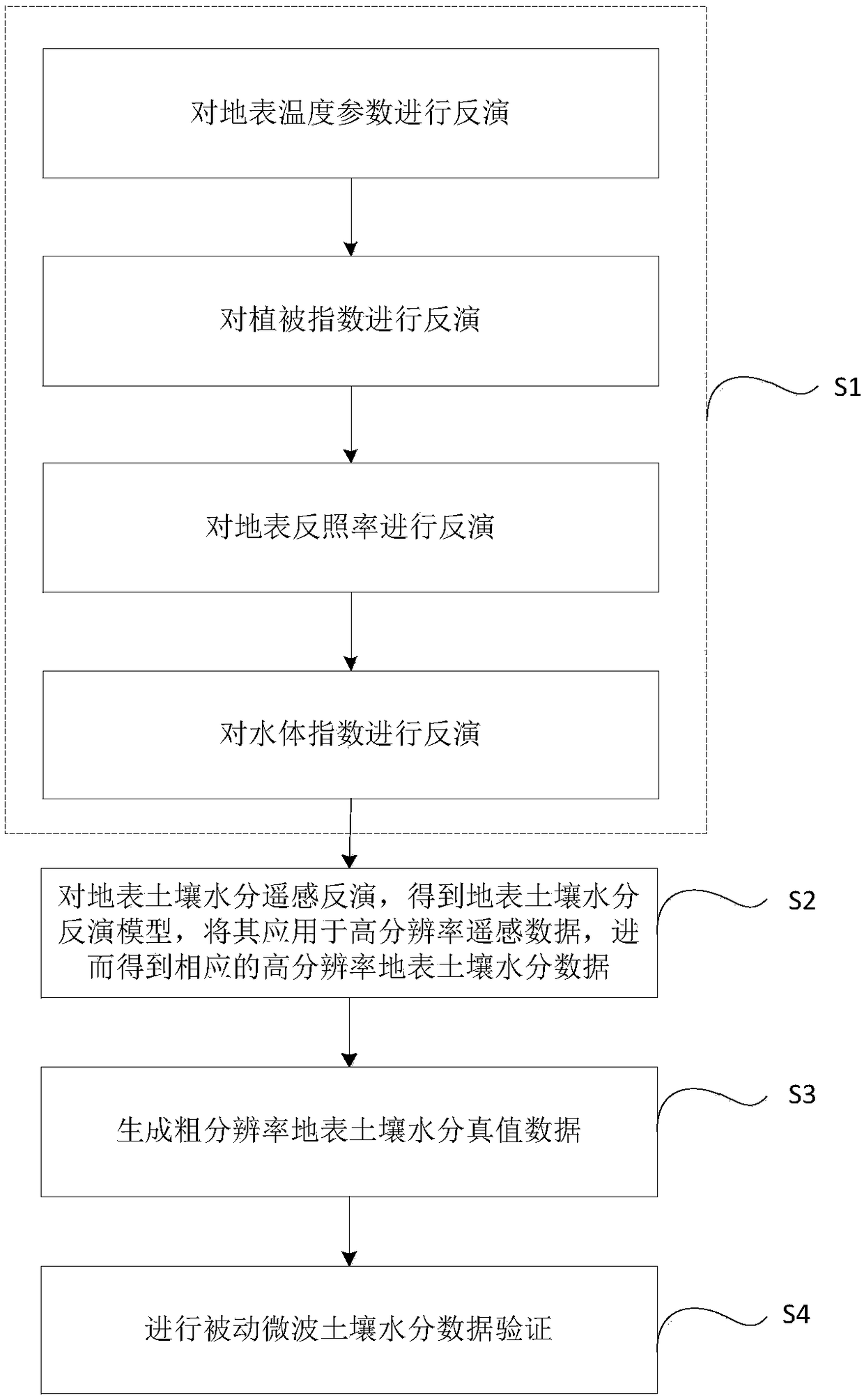
[0056] The technical solution of the present invention will be further described in detail below in conjunction with the accompanying drawings, but the protection scope of the present invention is not limited to the following description.

[0057] Such as figure 1 As shown, the present invention adopts multiple technologies such as remote sensing quantitative inversion, quantitative model construction, spatial scale upward push and comparative verification, etc., to develop a multi-level verification method for passive microwave surface soil moisture products based on high spatial resolution optical remote sensing data. The specific process as follows:

[0058] S1. Remote sensing inversion of key surface parameters in high spatial resolution optical remote sensing:

[0059] In the process of optical remote sensing estimation of surface soil moisture, surface soil moisture is often related to surface temperature, vegetation index, surface albedo and water body index. In order ...


PUM


Abstract

The invention discloses a multi-level passive microwave soil moisture verification method coupled with multi-source data, which comprises the following steps: S1. Based on optical remote sensing data,carrying out remote sensing quantitative inversion of key surface parameters; S2. Retrieving the surface soil moisture by remote sensing, obtaining the surface soil moisture retrieval model, applyingit to the high-resolution remote sensing data, and obtaining the corresponding high-resolution surface soil moisture data; 3, generating coarse resolution surface soil moisture true value data; S4. Performing Passive microwave soil moisture data validation. As that optical remote sensing data and the ground observation data are combined, A surface soil wat retrieval method based on optical remotesensing is established, Acquisition of high spatial resolution and accuracy of surface soil moisture data, high resolution soil moisture products through spatial aggregation to obtain passive microwave soil moisture products of the same scale of soil moisture data, effectively achieve the accurate verification of passive microwave soil moisture data.

Description

technical field [0001] The invention relates to soil moisture verification, in particular to a multi-level passive microwave soil moisture verification method coupled with multi-source data. Background technique [0002] Surface soil moisture is a basic parameter in the study of the formation, conversion, and consumption of land surface water resources. It is the link between surface water and groundwater, and the basic element for studying surface energy exchange. It plays a very important role in climate change. At the same time, soil moisture is an important content in the fields of soil science, hydrology, and ecology. Through the study of soil moisture spatiotemporal patterns, we can better understand soil physical and hydrological characteristics, so as to effectively integrate hydrological models with climate, The combination of ecological and other models at different scales to strengthen the understanding of land surface processes is an important part of the applica...

Claims


Application Information

Patent Timeline
Patent Type & Authority Applications(China)
IPC IPC(8): G06F17/50G06K9/00
CPCG06F30/20G06V20/13
Inventor 赵伟
Owner INST OF MOUNTAIN HAZARDS & ENVIRONMENT CHINESE ACADEMY OF SCI
Why Eureka
Try Eureka