Wind aloft inversion method based on Doppler weather radar data

A technology of weather radar and radar data, applied in radio wave reflection/re-radiation, climate sustainability, utilization of re-radiation, etc., can solve the problems of low wind field accuracy, poor stability, inconsistent spatial resolution, etc., to achieve Good integrity and continuity, moderate computational complexity, and improved readability

Active Publication Date: 2018-12-28
NANJING UNIV OF INFORMATION SCI & TECH
View PDF6 Cites 9 Cited by
  • Summary
  • Abstract
  • Description
  • Claims
  • Application Information

AI Technical Summary

Problems solved by technology

Due to the complexity of the weather system and the limitations of existing technical means, in actual business applications, there are still some defects and deficiencies in the inversion of the high-altitude live wind field
For example, it is relatively simple to use only the reflectivity factor and average radial velocity of a single radar to invert the wind field. The performance of the wind field is less accurate
Another example is the fusion of multivariate data such as radar radial velocity and cloud trail wind or water vapor conduction wind. This type of method is mainly limited by the inconsistent spatial resolution of different data, inconsistent correspondence between spatial grid points, and inconsistent observation time. The accuracy of the calculated wind field is sometimes high and sometimes low, and the stability is poor

Method used


Image

  • Wind aloft inversion method based on Doppler weather radar data
  • Wind aloft inversion method based on Doppler weather radar data
  • Wind aloft inversion method based on Doppler weather radar data

Examples


Embodiment 1

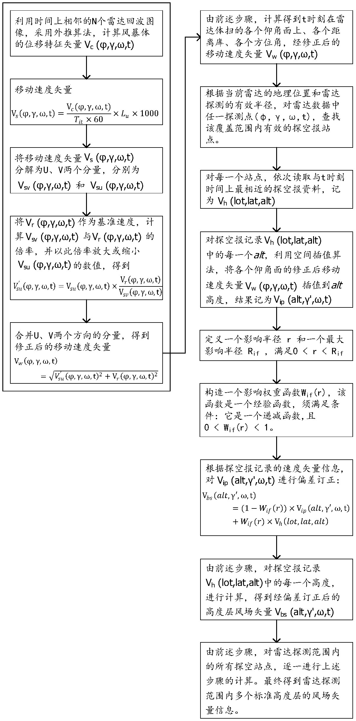
[0039] Such as figure 1 Shown, the present invention is based on the high-altitude wind inversion method of Doppler weather radar data, and this method comprises the following steps:

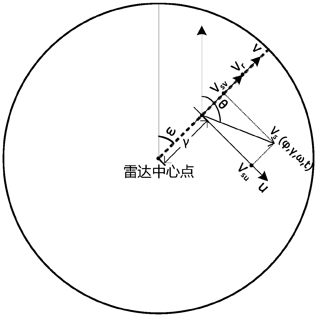
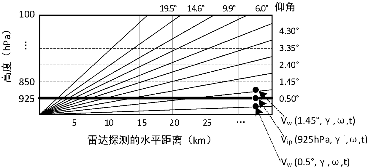
[0040] Step 1: Assuming that the upper-altitude wind at a certain time t is to be inverted, first select a radar, and use the radar data of this radar at time t and the N times closest to time t before (this data is in the form of basic reflectance data and average Radial velocity data), using extrapolation algorithms, such as the maximum correlation method, cross-correlation method, etc., to calculate the displacement feature vector of the storm body represented by the radar data at each detection point, and the displacement feature vector of any detection point is recorded as Among them, N is an integer of 2 Indicates a certain elevation plane of the radar volume scan, the number of elevation planes and the number of elevation angles of each elevation plane depend on the technical parameters of...


PUM


Abstract

The method provides a wind aloft inversion method based on Doppler weather radar data. The method utilizes extrapolation products and radial velocity products of the Doppler weather radar, and air sounding data to carry out a multi-level wind aloft field fusion. The invention utilizes an extrapolation result of a radar echo image to convert an average radial velocity field of each elevation planeinto a velocity vector field with U and V components, thereby improving the readability of a subjective analysis of the wind aloft field. The invention utilizes the air sounding data to appropriatelycorrect a radar wind field, and the strength of the correction decreases with the increase of the distance between a radar grid point and a sounding station, so that the wind field has better integrity and continuity, and is more accord with the condition of an actual atmospheric wind field. Compared with some multi-data fusion methods, the algorithm of the method provided by the invention has moderate computational complexity and can improve the timeliness of the secondary radar wind field output.

Description

technical field [0001] The invention belongs to the field of earth sciences, and in particular relates to a method for performing multi-level high-altitude wind inversion by using detection data such as Doppler weather radar. Background technique [0002] The upper-altitude wind field characteristics are one of the important objects for weather diagnosis and analysis, and play a vital role in the fields of meteorology, military and aerospace. At present, there are many ways to obtain the atmospheric wind field over the earth, such as observation or detection by means of sounding balloons, Doppler weather radars, wind profiler radars, and meteorological satellites. These devices and technical means have their own advantages. Among them, Doppler weather radar (hereinafter referred to as radar) has the characteristics of high detection space resolution, fast data update frequency and strong effectiveness. Forecasting and other aspects have been widely studied and applied. [...

Claims


Application Information

Patent Timeline
IPC IPC(8): G01S13/95
CPCG01S13/95Y02A90/10
Inventor 王兴卞浩瑄朱彬杨胜朋苗春生王军徐经纬
Owner NANJING UNIV OF INFORMATION SCI & TECH
Why Eureka
Try Eureka