
Urban planning dynamic monitoring system and method based on high-score remote sensing and unmanned aerial vehicle

A technology of urban planning and dynamic monitoring, applied in the field of information retrieval, can solve the problems of low accuracy, low accuracy of changing map land and feature recognition, and low accuracy of remote sensing monitoring, so as to improve spatial position accuracy and improve accuracy. Sexuality, the effect of increasing the time frequency

Inactive Publication Date: 2018-12-21
HUNAN CITY UNIV
View PDF2 Cites 18 Cited by
  • Summary
  • Abstract
  • Description
  • Claims
  • Application Information

AI Technical Summary

Problems solved by technology

[0008] (1) The accuracy of remote sensing monitoring of existing urban planning is not high, and the accuracy of identification of changing map spots and features is not high, and the accuracy is low;
[0009] (2) The existing urban planning remote sensing monitoring cannot automatically identify whether urban construction violates regulations
For violations of laws and regulations under construction, the sooner they are discovered, the less the impact on urban planning can be minimized. However, for changes in the nature of land use and whether the construction content meets the approved statutory urban planning requirements, such as manual visual interpretation, although it is possible Be accurate, but it is inevitable that the processing time for illegal construction activities will be delayed due to the large volume

Method used

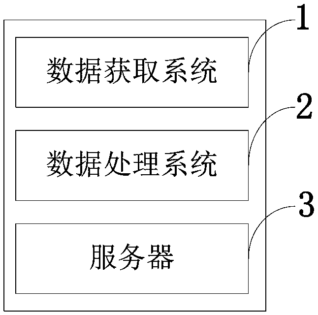
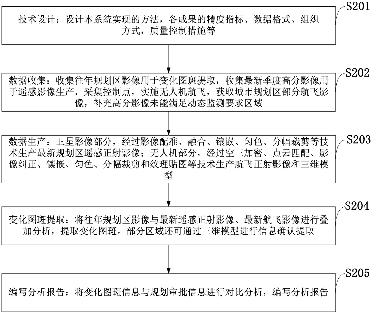
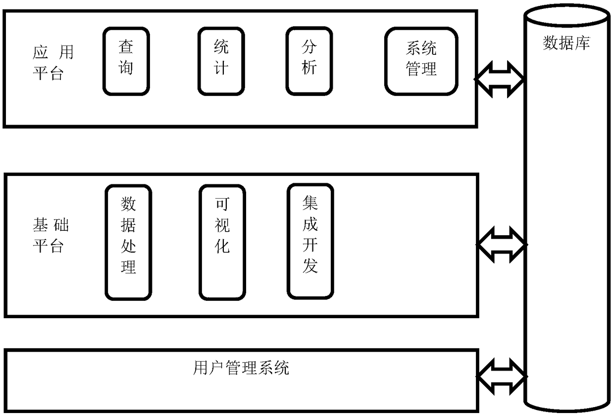

Image

  • Urban planning dynamic monitoring system and method based on high-score remote sensing and unmanned aerial vehicle
  • Urban planning dynamic monitoring system and method based on high-score remote sensing and unmanned aerial vehicle
  • Urban planning dynamic monitoring system and method based on high-score remote sensing and unmanned aerial vehicle

Examples


Embodiment Construction

[0037] In order to make the object, technical solution and advantages of the present invention more clear, the present invention will be further described in detail below in conjunction with the examples. It should be understood that the specific embodiments described here are only used to explain the present invention, not to limit the present invention.

[0038] The present invention aims to solve the problems of low precision and low accuracy of existing urban planning remote sensing monitoring by virtue of the advantages of high-resolution remote sensing satellite and UAV oblique photography technology, such as high resolution, speed, and flexibility, and establish a set of fast , Accurate multi-source remote sensing urban planning dynamic monitoring system to enhance the regulatory effectiveness of the management department on urban construction and achieve efficient planning management.

[0039] The application principle of the present invention will be described in deta...


PUM


Abstract

The invention belongs to information retrieval. And its database structure technology field, discloses a city planning dynamic monitoring system and method based on high-score remote sensing and unmanned aerial vehicle, which utilizes high-score satellite remote sensing data to improve the time frequency and spatial position precision of the change patch identification of the city planning area; UAV image acquisition technology and tilt photography modeling technology are used to improve the accuracy of land use types and features recognition and provide better image data source for urban planning monitoring. According to the accurate extraction technology of change patch, the change patch is connected with the planning approval system, and the matching degree between the planning contentand the construction content of the change patch is automatically identified by the technology of spatial superposition and attribute analysis, and the illegal construction behaviors such as construction without approval and construction not according to the planning approval content are automatically identified by the system.

Description

technical field [0001] The invention belongs to the technical field of information retrieval; and database structure thereof, and in particular relates to a dynamic monitoring system and method for urban planning based on high-resolution remote sensing and unmanned aerial vehicles. Background technique [0002] At present, the existing technologies commonly used in the industry are as follows: with the progress of society and economic development, people's living standards are gradually improving, and environmental awareness is becoming stronger. At the same time, more and more attention is paid to urban planning: to protect the All the resources in the region can solve the problems in the city and the problems that may appear in the foreseeable future, making it more suitable for human habitation. Bringing greater harmony to the humans that inhabit the area. Cities are the product of human social, economic and cultural development to a certain stage. The reason and time o...

Claims


Application Information

Patent Timeline
IPC IPC(8): G06K9/00G06Q50/26
CPCG06Q50/26G06V20/176
Inventor 汤放华张曦陈益平周松林颜紫科罗瑶肖敏易海莫文波舒适宁家乐杨楠吴颖吴丁花李小舟
Owner HUNAN CITY UNIV
Learn More