A gridded reconstruction method of grass yield spatial data

A technology of spatial data and grass yield, applied in the field of data reconstruction, can solve problems such as gaps, and achieve the effect of easy reconstruction and simple data acquisition

Active Publication Date: 2020-07-28
INST OF GEOGRAPHICAL SCI & NATURAL RESOURCE RES CAS
View PDF8 Cites 0 Cited by
  • Summary
  • Abstract
  • Description
  • Claims
  • Application Information

AI Technical Summary

Problems solved by technology

However, for a certain historical period, such as the 1980s, in the absence of quadrat survey data and remote sensing data, how to restore the current situation of grass yield in the 1980s and how to reconstruct the spatial distribution data of grass yield at that time, in the technical and the method is still a blank

Method used


Image

  • A gridded reconstruction method of grass yield spatial data
  • A gridded reconstruction method of grass yield spatial data
  • A gridded reconstruction method of grass yield spatial data

Examples


Embodiment Construction

[0055] In order to make the object, technical solution and advantages of the present invention clearer, the present invention will be further described in detail below in conjunction with the accompanying drawings and examples.

[0056] A method for gridded reconstruction of grassland grass volume spatial data, comprising the following steps:

[0057] Step 1. Data collation of grassland resources survey in the 1980s

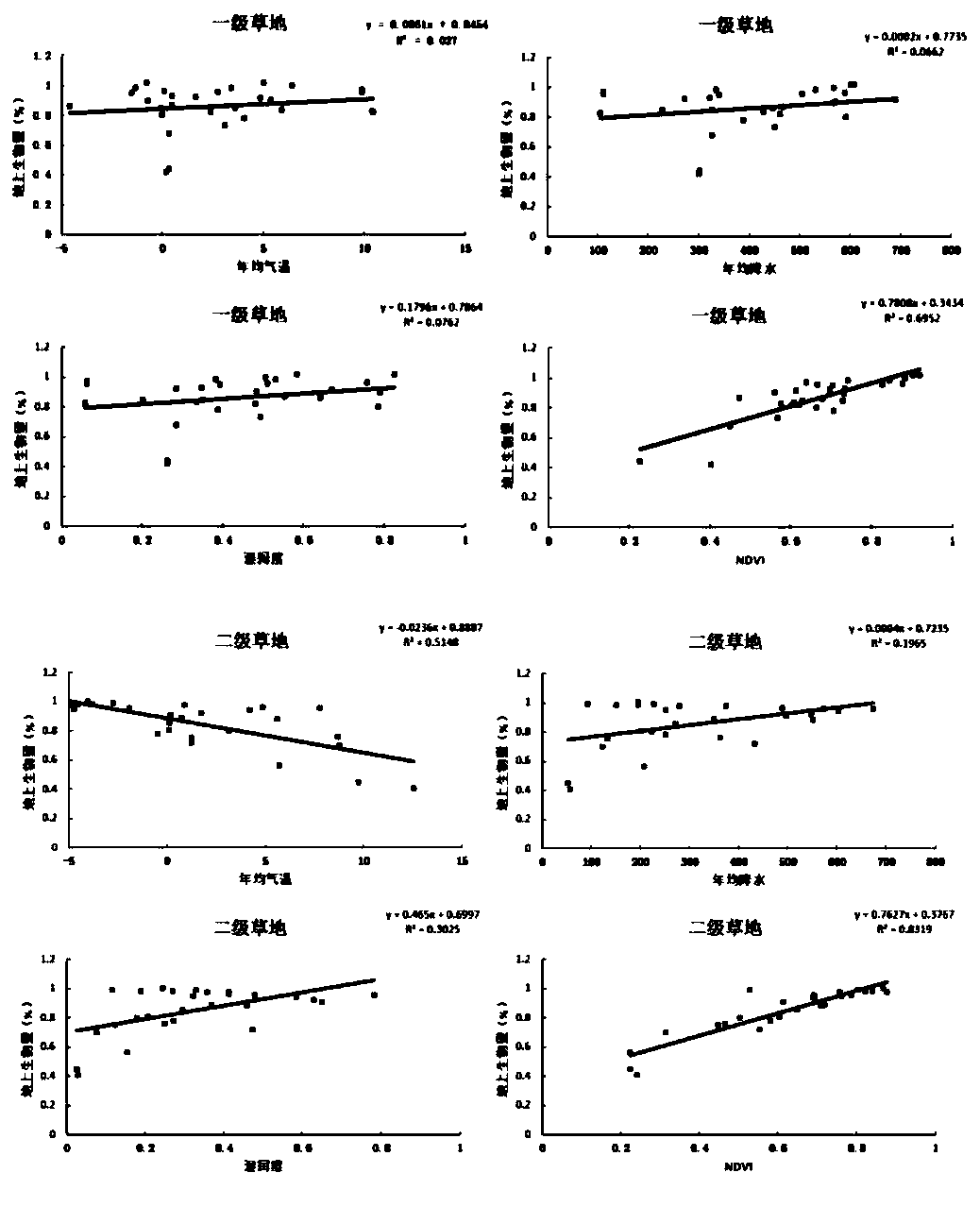
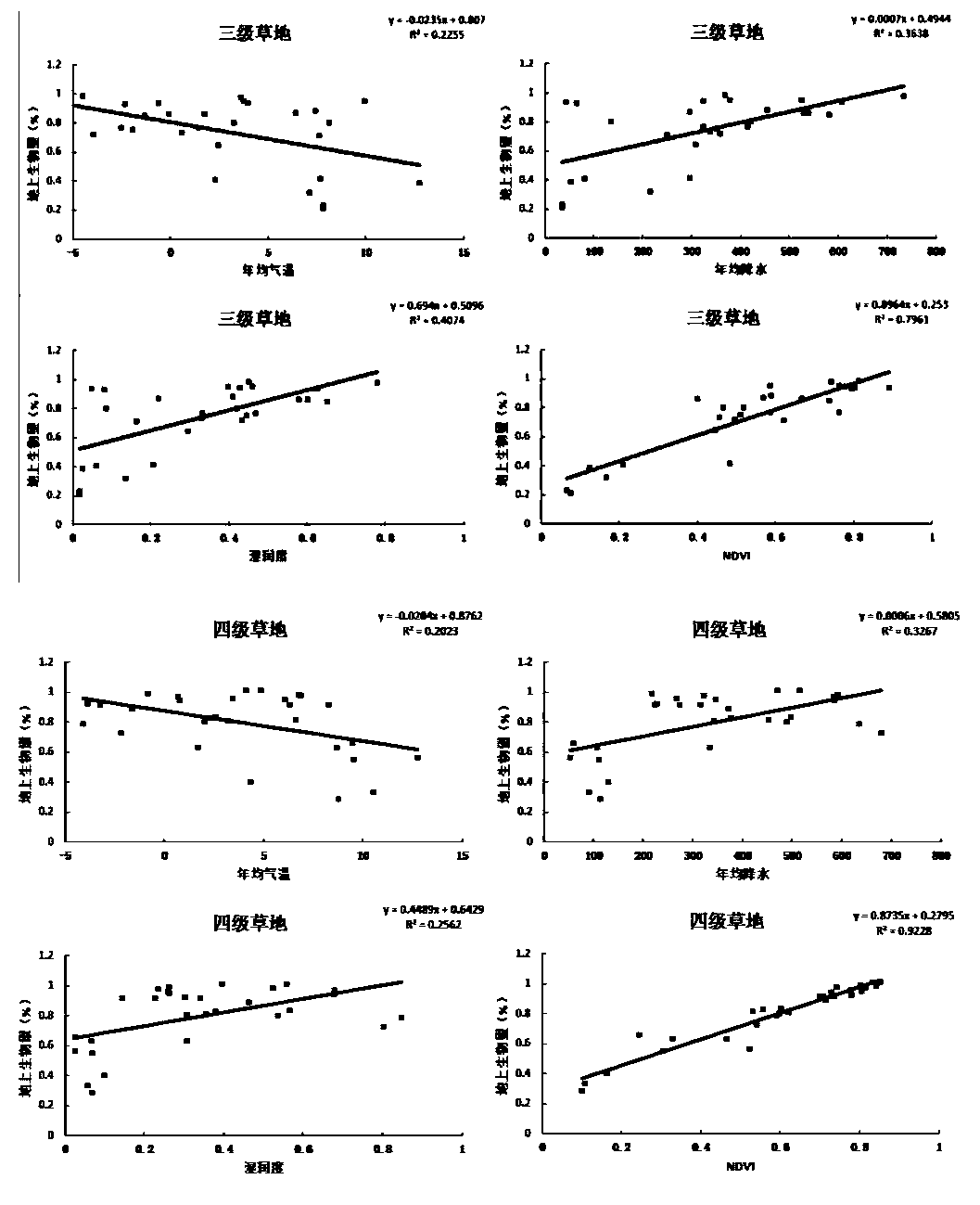
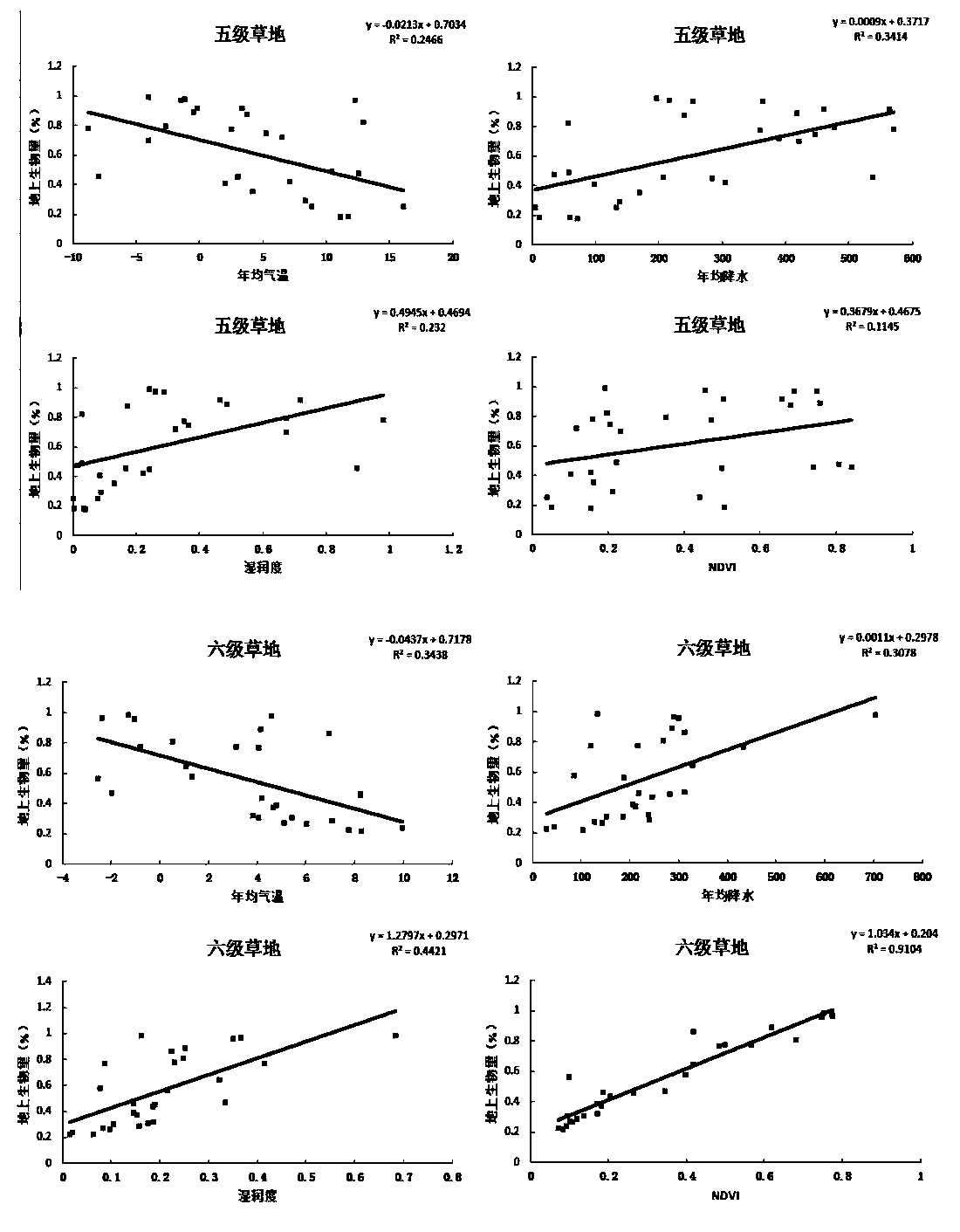
[0058] According to the statistical results of grassland surveys in the 1980s, grasslands in China were divided into 8 grades according to the grass yield. In this method, the upper limit of grass yield at all levels is used as the basic data for spatial interpolation of grass yield, and the grass yield of level 1 grassland is set at 600g / m 2 .

[0059] Table 1 Grass yield of different grassland grades in 1980s

[0060]

[0061] The grassland survey in the 1980s divided my country's grassland into 18 grassland types, and the average grass yield of the 18 gr...


PUM


Abstract

The invention discloses a grassland grass yield space data grid reconstruction method, which comprises the following steps: 1, arranging grassland resources investigation data; 2, preparing and processing the spatial data of the geographic elements; 3, collecting geographic element data and grass yield data; 4, performing regression analysis of the grass yield gradient change in the grassland; 5,constructing a grass yield model and calculate the grass yield of a spatial grid; 6, analyzing the spatial pattern of grass yield; 7, performing data quality verification. The method has the advantages of spatial meshing, simple data acquisition, and restoration and reconstruction of missing historical data. The method can restore and reconstruct the spatial distribution data of grass yield in thesteppe region of northern china in 1980s to make up for the loss of spatial distribution data of grass yield. The invention not only provides a method for restoration and reconstruction of historicalmissing spatial data, but also provides an effective data base and technical support for animal husbandry, grassland degradation and environmental ecological security assessment.

Description

technical field [0001] The invention relates to the technical field of data reconstruction, in particular to a gridded reconstruction method for spatial data of grassland grass quantity in grassland animal husbandry production. Background technique [0002] Grassland is one of the largest terrestrial ecosystems, and it is also the largest ecosystem on land in China. As an important renewable resource, grassland is the basis of animal husbandry production and the basic means of production for herdsmen. Calculating the natural conditions, type, quantity, quality, spatial distribution range, grass yield and other information of grassland resources is of great significance for government departments to guide rational grazing and sustainable use of resources. Among them, grass yield is the most important grassland resource attribute, and it is the basis for scientifically formulating grassland livestock capacity. [0003] At present, there are relatively mature methods for esti...

Claims


Application Information

Patent Timeline
Patent Type & Authority Patents(China)
IPC IPC(8): G06F30/18G06F111/02G06F111/10
CPCG06F30/18
Inventor 朱华忠钟华平乔宇鑫钟运琴李愈哲邵小明李长春
Owner INST OF GEOGRAPHICAL SCI & NATURAL RESOURCE RES CAS
Why Eureka
Try Eureka