
A method and device for quantifying spatiotemporal coverage of a road weather information system

A weather information and coverage technology, applied in the field of traffic information, can solve the problem of lack of quantification method of space-time coverage, and achieve the effect of improving accuracy

Active Publication Date: 2022-07-22
SHANDONG UNIV
View PDF3 Cites 0 Cited by
  • Summary
  • Abstract
  • Description
  • Claims
  • Application Information

AI Technical Summary

Problems solved by technology

However, most of the existing studies use empirical methods to expand the network of road weather information systems, and there is still a lack of quantitative methods for temporal and spatial coverage.

Method used


Image

  • A method and device for quantifying spatiotemporal coverage of a road weather information system
  • A method and device for quantifying spatiotemporal coverage of a road weather information system
  • A method and device for quantifying spatiotemporal coverage of a road weather information system

Examples


Embodiment Construction

[0057] It should be noted that the following detailed description is exemplary and intended to provide further explanation of the application. Unless otherwise defined, all technical and scientific terms used herein have the same meaning as commonly understood by one of ordinary skill in the art to which this application belongs.

[0058] It should be noted that the terminology used herein is for the purpose of describing specific embodiments only, and is not intended to limit the exemplary embodiments according to the present application. As used herein, unless the context clearly dictates otherwise, the singular is intended to include the plural as well, furthermore, it is to be understood that when the terms "comprising" and / or "including" are used in this specification, it indicates that There are features, steps, operations, devices, components and / or combinations thereof.

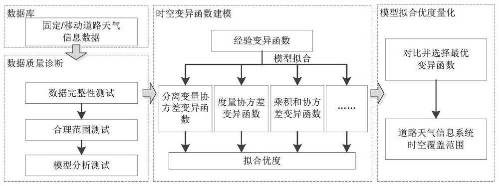
[0059] figure 1 It is a flow chart of a method for quantifying the spatiotemporal coverage of ro...


PUM


Abstract

The invention discloses a method and a device for quantifying the spatiotemporal coverage of a road weather information system. Wherein, the method includes grouping numbers of weather information sensors, and storing the road weather data collected by the weather information sensors in corresponding groups according to the group numbers, so as to construct a road weather information system database; Quality diagnosis, removing invalid and wrong data; using the data after quality diagnosis, using empirical variogram to construct and fit at least two types of spatiotemporal variogram models to obtain fitted model parameters and goodness of fit; By comparing the goodness of fit of all the constructed spatiotemporal variogram models, the best fitting model is selected, and the spatiotemporal coverage of road weather data is determined. It quantifies and visualizes the spatiotemporal coverage of the road weather information system and takes into account the combined effect of spatiotemporal factors.

Description

technical field [0001] The invention belongs to the field of traffic information, and in particular relates to a method and device for quantifying the spatiotemporal coverage of a road weather information system. Background technique [0002] Road weather affects traffic conditions. According to statistics, about 22% of road traffic accidents and 25% of trip delays are related to bad weather. Bad weather not only worsens road driving conditions, but also seriously affects drivers' driving behavior. The special geographical conditions of the road make the road weather changeable, and it is easy to produce short-term or long-term special weather conditions such as rain, snow, and fog in the local area. Such weather conditions are difficult to predict through the meteorological department. Therefore, it is necessary to collect and process road weather conditions in time, establish a corresponding information system, and use quantitative methods to study the spatiotemporal cove...

Claims


Application Information

Patent Timeline
Patent Type & Authority Patents(China)
IPC IPC(8): G06F16/29G06F16/215G06F16/9537
Inventor 王旭牛磊李江晨张璨
Owner SHANDONG UNIV
Learn More