A road surface point cloud intensity enhancement method based on vehicle laser scanning data

A vehicle-mounted laser scanning and laser spot technology, applied in complex mathematical operations and other directions, can solve problems such as the inability to accurately characterize the material properties of the target surface

Active Publication Date: 2020-12-25
FUZHOU UNIV
View PDF5 Cites 0 Cited by
  • Summary
  • Abstract
  • Description
  • Claims
  • Application Information

AI Technical Summary

Problems solved by technology

[0009] The purpose of the present invention is to overcome the problem that the road surface point cloud intensity in the vehicle-mounted laser scanning data is easily affected by factors such as scanning distance and point cloud density distribution, and cannot accurately characterize the material characteristics of the target surface, and it is difficult to use the intensity to segment the road surface target. A road surface point cloud intensity enhancement method based on vehicle-mounted laser scanning data, which enhances the point cloud intensity, eliminates the influence of distance geometric factors on point cloud intensity, and suppresses the intensity value distribution caused by inconsistent road surface roughness. Wide range, spatial distribution Dense intensity noise, filtering out the "salt and pepper noise" and "Gaussian noise" in the point cloud intensity, and finally realize the effective suppression of the intensity difference in the homogeneous point cloud, and the expansion of the intensity difference between the non-homogeneous point cloud, which is the later point cloud Processing such as point cloud extraction of road markings, providing accurate intensity feature expression

Method used


Image

  • A road surface point cloud intensity enhancement method based on vehicle laser scanning data
  • A road surface point cloud intensity enhancement method based on vehicle laser scanning data
  • A road surface point cloud intensity enhancement method based on vehicle laser scanning data

Examples


Embodiment Construction

[0083] The present invention will be described in detail below in conjunction with the accompanying drawings and specific embodiments. This embodiment is carried out on the premise of the technical solution of the present invention, and detailed implementation and specific operation process are given, but the protection scope of the present invention is not limited to the following embodiments.

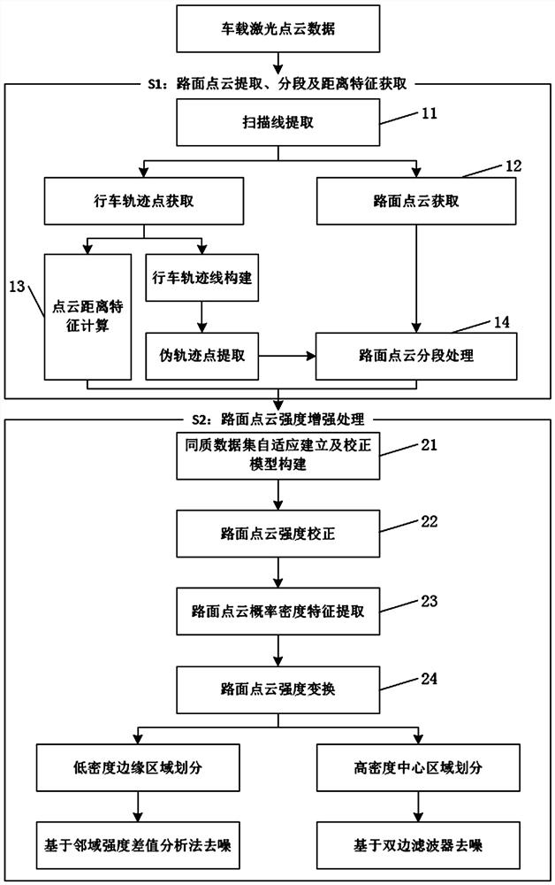
[0084] Such as figure 1 As shown, a road surface point cloud intensity enhancement method based on vehicle-mounted laser scanning data includes the following steps:

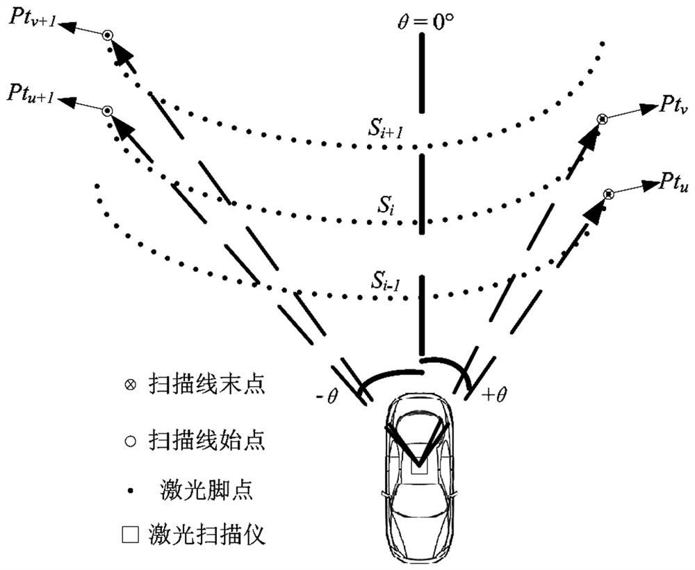
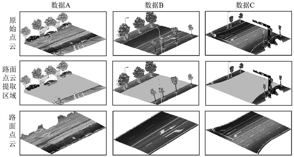
[0085] S1: Based on the scanning line of the vehicle-mounted laser scanning data, obtain the road surface point cloud, the driving trajectory line, and the distance from the laser point to the driving trajectory line in the road surface point cloud (referred to as the point cloud distance feature), and analyze the road surface point cloud based on the driving trajectory line. segment to get the road point cloud segment....


PUM


Abstract

The invention discloses a vehicle-mounted laser scanning data-based road surface point cloud strength enhancing method. The method comprises the following steps of: S1, obtaining a road surface pointcloud, a wheel path line and a distance from a laser point in the road surface point cloud to the wheel path line on the basis of vehicle-mounted laser scanning data, and segmenting the road surface point cloud; and S2, taking road surface point cloud segments as processing units to carry out the following steps of: 21, constructing an original distance model function and a reference distance model function, 22, carrying out strength correction on the laser point by adoption of ratio method and a difference value method, 23, carrying out strength conversion on the laser point, and 24, carryingout strength denoising on the laser point by adoption of a multi-filter integration method, so as to complete laser point strength enhancement of each road surface point cloud segment in the road surface point cloud. Compared with the prior art, the method is capable of remarkably enhancing the strength differences between different target materials of road surfaces and eliminating the strengthennoise in local homogeneous areas.

Description

technical field [0001] The invention relates to the field of vehicle-mounted laser scanning point cloud data processing, in particular to a road surface point cloud intensity enhancement method based on vehicle-mounted laser scanning data. Background technique [0002] The vehicle-mounted laser point cloud intensity is used as the backscattered echo intensity of the target to the emitted laser, which characterizes the reflection spectrum characteristics of the measured target to the laser, and is widely used in the research field of road marking extraction. However, the point cloud reflection intensity acquired by the vehicle-mounted laser scanning system is not only related to the reflectivity of the surface of the surface object, but also affected by factors such as the distance between the object and the laser scanner, the incident angle of the laser, and the speed of the vehicle. Due to the different angles and distances of ground objects, there is uneven distribution of...

Claims


Application Information

Patent Timeline
Patent Type & Authority Patents(China)
IPC IPC(8): G06F17/15
CPCG06F17/15
Inventor 方莉娜黄志文罗海峰
Owner FUZHOU UNIV
Why Eureka
Try Eureka