Airplane detection method based on airport remote sensing image

A technology of remote sensing images and airports, which is applied in the field of remote sensing image processing and can solve problems such as poor practicability

Inactive Publication Date: 2018-09-21
NORTH CHINA UNIVERSITY OF TECHNOLOGY
View PDF1 Cites 7 Cited by
  • Summary
  • Abstract
  • Description
  • Claims
  • Application Information

AI Technical Summary

Problems solved by technology

Usually, the form of matching template designed by this type of method has certain limitations; and the imaging of optical remote sensing images is easily affected by factors such as satellite angle and lighting conditions, which makes the feature appearance and grayscale characteristics of aircraft targets on remote sensing images have many changes. , so the use of common template matching technology is not very practical in actual scenarios

Method used


Image

  • Airplane detection method based on airport remote sensing image
  • Airplane detection method based on airport remote sensing image

Examples


Embodiment Construction

[0015] In order to make the purpose, technical solutions and advantages of the embodiments of the present invention clearer, the technical solutions in the embodiments of the present invention will be clearly and completely described below in conjunction with the drawings in the embodiments of the present invention. Obviously, the described embodiments It is a part of embodiments of the present invention, but not all embodiments. Based on the embodiments of the present invention, all other embodiments obtained by persons of ordinary skill in the art without making creative efforts belong to the protection scope of the present invention.

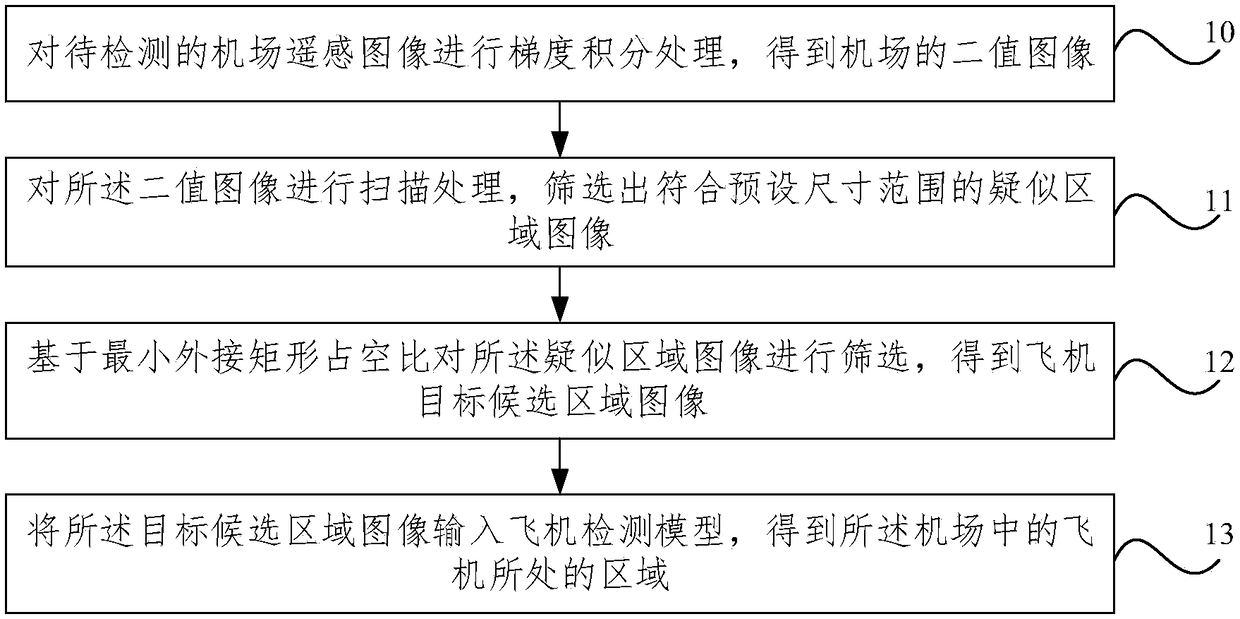
[0016] figure 1 It is a flowchart of an aircraft detection method based on an airport remote sensing image provided by an embodiment of the present invention, such as figure 1 As shown, the method includes:

[0017] Step 10, performing gradient integral processing on the remote sensing image of the airport to be detected to obtain a binary ...


PUM


Abstract

The invention provides an airplane detection method based on an airport remote sensing image. The method comprises the following steps: carrying out gradient integration processing on an airport remote sensing image to be detected to obtain a binary image of an airport; carrying out scanning processing on the binary image to screen out suspected area images according with a preset size range; screening the suspected area images based on duty ratio of a minimum bounding rectangle to obtain a target candidate area image of the airplane; and inputting the target candidate area image to an airplane detection model to obtain an area of the airplane in the airport. The method can finish airport airplane detection efficiently and accurately without carrying out template matching or total graph filtering.

Description

technical field [0001] The invention relates to the technical field of remote sensing image processing, in particular to an aircraft detection method based on airport remote sensing images. Background technique [0002] With the rapid development of remote sensing image processing technology, the importance of its application in various fields has been greatly enhanced. In civilian use, it is mainly used for artificial ground object monitoring, agricultural production estimation and disaster early warning, etc.; in military use, it is mainly used to efficiently detect important military targets in a wide field of view, such as ships, aircraft, and military vehicles. Among them, aircraft, as an important target object for civil and military use, is one of the research hotspots in the field of remote sensing image processing applications. [0003] In the related work of aircraft detection in the airport area based on optical remote sensing images, there are various detection ...

Claims


Application Information

Patent Timeline
Patent Type & Authority Applications(China)
IPC IPC(8): G06T7/254
CPCG06T7/254G06T2207/10032
Inventor 毕福昆雷明阳侯金元杨志华韩健鸿
Owner NORTH CHINA UNIVERSITY OF TECHNOLOGY
Why Eureka
Try Eureka