
Satellite-borne panchromatic and multispectral image fusion method

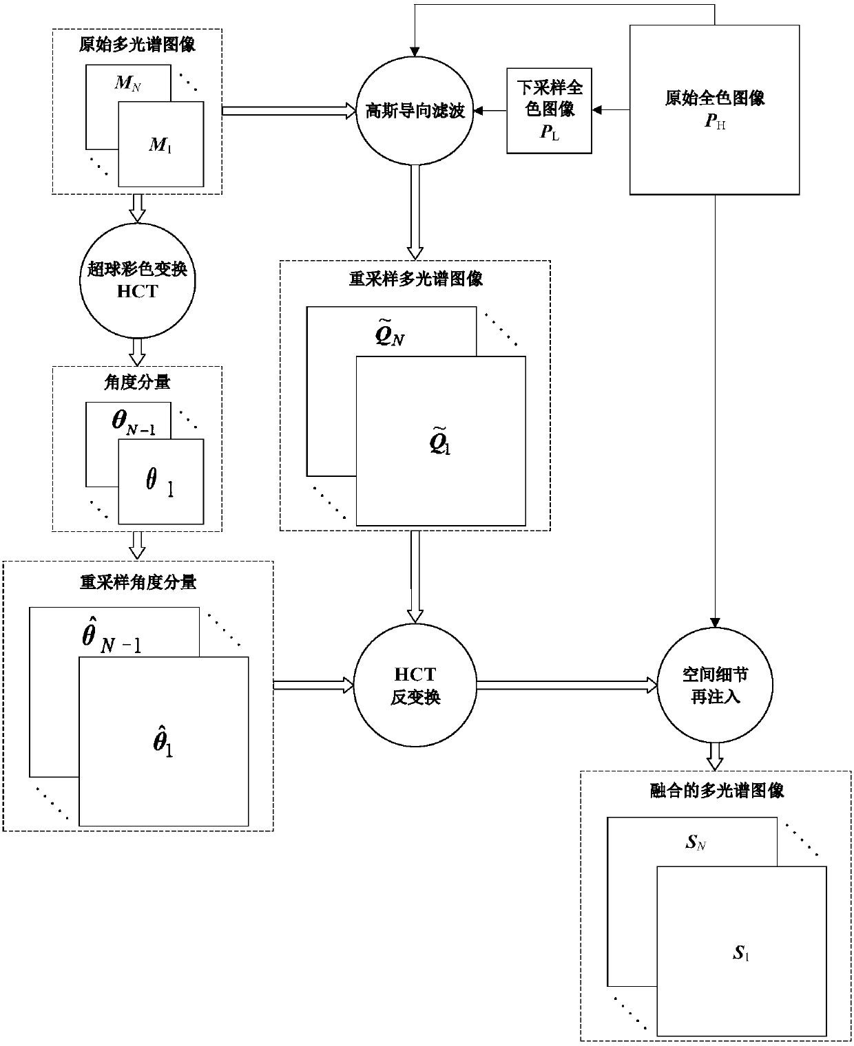
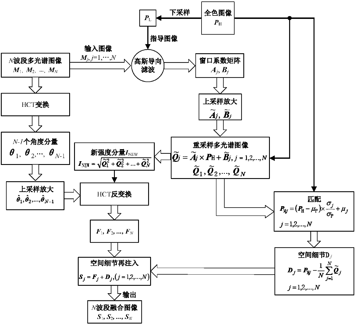
A multi-spectral image and panchromatic image technology, which is applied in the field of visualization enhancement processing of spaceborne remote sensing images, can solve the problems of spectral distortion and spatial information distortion, affecting the preservation of fusion image information, and the resolution of resampling enlarged images is not improved. , to achieve the effect of improving spectral fidelity, improving spatial resolution, universality and practicability

Inactive Publication Date: 2018-09-14
NORTHWESTERN POLYTECHNICAL UNIV
View PDF3 Cites 3 Cited by
  • Summary
  • Abstract
  • Description
  • Claims
  • Application Information

AI Technical Summary

Problems solved by technology

In fact, the multispectral image obtained by the above interpolation method will have different degrees of spectral distortion and spatial information distortion, which will further affect the information preservation of the fused image (see the literature IEEE Geoscience and Remote Sensing Letters, 4(1):27-31, 2007; IEEE Journal of Selected Topics in Signal Processing, 5(3):446-453, 2011)
In addition, the classical interpolation method cannot improve the spatial resolution of the resampled enlarged image, because the external useful high-spatial-resolution detail information is not utilized in the interpolation process, so the definition of the resampled enlarged image has not been improved.

Method used


Image

  • Satellite-borne panchromatic and multispectral image fusion method
  • Satellite-borne panchromatic and multispectral image fusion method
  • Satellite-borne panchromatic and multispectral image fusion method

Examples


Embodiment

[0076] Embodiment: Using the real WorldView-2 spaceborne remote sensing multispectral image and panchromatic image, the multispectral image includes eight bands, denoted as M 1 , M 2 ,...,M 8 , the panchromatic image is a single band, denoted as P H . The spatial resolution of the multispectral images is 2.0 m and the size is 200 rows by 200 columns. The panchromatic image has a spatial resolution of 0.5 meters and a size of 800 rows by 800 columns. Implementing the present invention comprises the following steps:

[0077] The first step, downsampling the full-color image

[0078] Since the spatial resolution of the panchromatic image is four times that of the multispectral image, the size of the panchromatic image is four times that of the multispectral image, so the panchromatic image needs to be down-sampled twice. Here the low-pass filter is selected to use the low-pass filter CDF9 in the Cohen-Daubechies-Fauveau (CDF) 9 / 7 biorthogonal filter bank, that is, LPF=[0.02...


PUM


Abstract

The invention provides a satellite-borne panchromatic and multispectral image fusion method. The satellite-borne panchromatic and multispectral image fusion method includes the steps: using Gaussian guided filtering to combine with a panchromatic image to complete resampling amplification of an original multispectral image; injecting the spatial detail information of the panchromatic image into the amplified multispectral image through the combination upsampling process, and then performing hyperspherical color transform (HCT) on the original multispectral image to extract the spectral information of the original multispectral image; and fusing the spectral information with the spatial information of the panchromatic image in the hyperspherical color space, and obtaining a multispectral image with high spatial resolution through HCT inverse transform. The satellite-borne panchromatic and multispectral image fusion method improves the spatial resolution of the resampled multispectral image, can be directly extended to fusion processing of the hyperspectral image, and is relatively higher in universality and practicality.

Description

technical field [0001] The invention relates to a visualization enhancement processing technology of a space-borne remote sensing image, in particular to an image fusion method of a space-borne panchromatic image and a multispectral image. Background technique [0002] Due to the physical limitations of the imaging sensor itself and the barriers of data transmission technology between the satellite and the ground, the current spaceborne imaging sensors can only provide multi-band multispectral images with high spectral resolution but low spatial resolution or high spatial resolution but spectral information. Poor single-band panchromatic images. On-orbit spaceborne sensors, such as GeoEye-1, WorldView-2 / 3 / 4, Gaojing-1, etc., can simultaneously provide multi-band multi-spectral remote sensing images and single-band panchromatic images with high spatial resolution. By fusing multispectral images and panchromatic images, the spatial resolution of multispectral images can be im...

Claims


Application Information

Patent Timeline
Patent Type & Authority Applications(China)
IPC IPC(8): G06T5/50G06T3/40
CPCG06T3/4053G06T5/50G06T2207/10036G06T2207/20024G06T2207/20221
Inventor 李旭潘煜高昂李立欣
Owner NORTHWESTERN POLYTECHNICAL UNIV
Learn More