
Unmanned plane formation flight method and system based on binocular visual sense

A binocular vision, formation flight technology, applied in the field of computer vision and flight control, can solve the problems of easy damage, GPS signal loss, waste of resources, etc., to achieve the effect of accurate control and high measurement accuracy

Inactive Publication Date: 2018-05-18
NANJING UNIV OF AERONAUTICS & ASTRONAUTICS
View PDF7 Cites 28 Cited by
  • Summary
  • Abstract
  • Description
  • Claims
  • Application Information

AI Technical Summary

Problems solved by technology

[0004] At present, the sensors used for UAV formation flight are usually GPS / INS, but GPS has the unavoidable defect of signal loss, which is easily destroyed during war, and in formation flight in unknown environment, the use of GPS there are still risks
Moreover, some wingmen will not return after performing missions, and the installation of expensive inertial navigation equipment will cause a great waste of resources
[0005] In summary, the current navigation method of UAV formation flight cannot meet the high-precision and high-accuracy navigation requirements under combat conditions.

Method used


Image

  • Unmanned plane formation flight method and system based on binocular visual sense
  • Unmanned plane formation flight method and system based on binocular visual sense
  • Unmanned plane formation flight method and system based on binocular visual sense

Examples


Embodiment Construction

[0028] In order to enable those skilled in the art to better understand the technical solutions of the present invention, the present invention will be further described in detail below in conjunction with specific embodiments.

[0029] The embodiment of the present invention provides a drone formation flying method based on binocular vision, including:

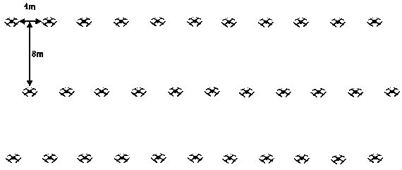
[0030] S1. The lead plane leads the wingman to take off and takes off from the ground in a specific formation, such as figure 2 As shown, flying to the work site under the leadership of the lead plane, the binocular camera on the lead plane takes a photo of the wingman;

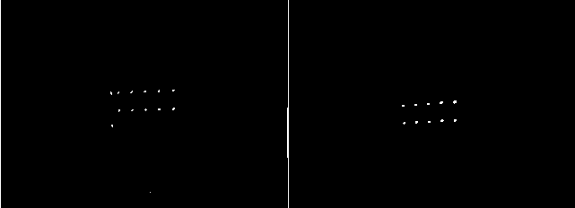
[0031] S2. The onboard computer on the long machine collects the photo, and the onboard computer performs color channel separation and thresholding processing on the photo to obtain a binary image;

[0032] S3. The onboard computer extracts the contour of the binary image, and extracts the contour of the infrared LED lamp on the binary image;

[0033] S4. The on-boar...


PUM


Abstract

The invention discloses an unmanned plane formation flight method and system based on binocular visual sense, and relates to the computer vision and flight control field; the method and system processimages so as to obtain unmanned plane navigation positioning attitude parameters, thus accurately positioning and navigating the unmanned plane formation; the flight system comprises a ground station, a lead aircraft and a wing plane; the flight method comprises the following steps: the lead aircraft leads the wing plane to fly and takes images of the wind plane; an airborne computer extracts aninfrared LED lamp contour from the image, and marks the center coordinates of the infrared LED lamp contour as the two dimension coordinates of the wing plane in the image; a binocular camera resolvesthe corresponding wing plane depth distance, and the image plane two dimension coordinates are combined to obtain the three dimensional coordinates of the unmanned plane under the camera coordinate system; the airborne computer calculates the ideal coordinates according to the route plan, sends the real coordinates and the ideal coordinates to the flight control of the wing plane, thus allowing the flight control to correct the wing plane positions.

Description

Technical field [0001] The invention belongs to the field of computer vision and flight control, and particularly relates to a drone formation flying method and system based on binocular vision. Background technique [0002] The advantages of multi-rotor UAVs are obvious. Compared with fixed-wing UAVs, it can take off and land vertically, hover at a fixed point, and fly upside down. It has strong maneuverability. Compared with single-rotor helicopters, multi-rotor drones have simple structure, convenient maintenance, easy loading and unloading, and easy operation. These characteristics make it widely used in many fields. In addition, the continuous development of related fields such as artificial intelligence, sensors, control algorithms, microelectronics, and wireless communication networks have made multi-rotor drones more intelligent and capable of completing more complex tasks. However, multi-rotor UAVs still have unsurpassed shortcomings, such as short battery life, small l...

Claims


Application Information

Patent Timeline
Patent Type & Authority Applications(China)
IPC IPC(8): G05D1/10G01C21/16G01C21/20G01C11/02G01C11/04
CPCG01C11/02G01C11/04G01C21/165G01C21/20G05D1/104
Inventor 杨喻茸孙朋张子豪王新华
Owner NANJING UNIV OF AERONAUTICS & ASTRONAUTICS
Learn More