
Unmanned aerial vehicle landing landform image classification method based on DCT-CNN model

A technology of DCT-CNN and classification method, which is applied in the direction of biological neural network model, computer parts, character and pattern recognition, etc., can solve the problems of increased training model time, complex structure, and inconspicuous differences, so as to shorten the training time, Effects that are simple to calculate and less time-consuming

Active Publication Date: 2018-03-02
BEIJING UNIV OF TECH
View PDF6 Cites 24 Cited by
  • Summary
  • Abstract
  • Description
  • Claims
  • Application Information

AI Technical Summary

Problems solved by technology

[0004] The shortcomings of existing methods: On the one hand: when the UAV lands in an unknown area, the differences between the obstacles on the landform and the surrounding environment are generally not obvious, and most of the landform images have the characteristics of complex scenes and rich information, so multi-layered images are required. The CNN model learns the layer-by-layer feature of the image and expresses it with more accurate high-level semantic features; on the other hand, the CNN model has many layers and complex structure. The time for training the model is greatly increased, and the increase in training parameters makes it difficult to adjust the parameters. If the training time is too long, the deep features will not be easily learned, and most of the deep feature information will be lost.

Method used


Image

  • Unmanned aerial vehicle landing landform image classification method based on DCT-CNN model
  • Unmanned aerial vehicle landing landform image classification method based on DCT-CNN model
  • Unmanned aerial vehicle landing landform image classification method based on DCT-CNN model

Examples


Embodiment Construction

[0032] Embodiments of the present invention are described in detail below, examples of which are shown in the drawings, wherein the same or similar reference numerals designate the same or similar elements or elements having the same or similar functions throughout. The embodiments described below by referring to the figures are exemplary only for explaining the present invention and should not be construed as limiting the present invention.

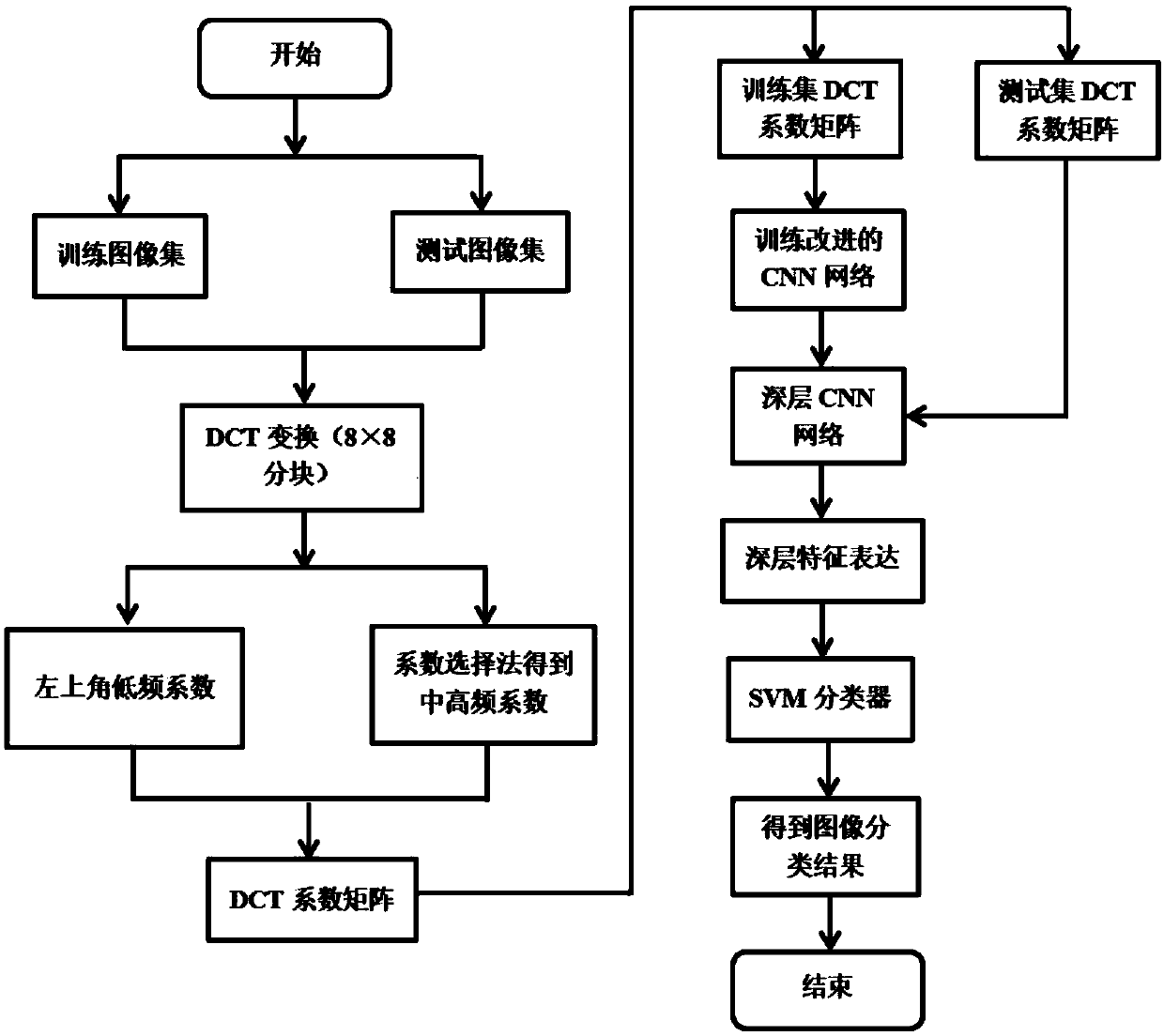
[0033] like figure 1 Shown, according to the UAV landing landform image classification method based on DCT-CNN model of the present invention, comprise the following several steps:

[0034] Step S1: Obtain a training image set and a test image set of the UAV landing landform;

[0035] Step S2: DCT transformation of the UAV landform image, and screening of DCT coefficients;

[0036] After an image is transformed by DCT, most of the energy of the image is concentrated in the low-frequency DCT coefficients, so the low-frequency coefficien...


PUM


Abstract

The invention discloses an unmanned aerial vehicle landing landform image classification method based on a DCT-CNN model. The method comprises the following steps of acquiring a training image set anda test image set of unmanned aerial vehicle landing landform images; carrying out DCT conversion on the unmanned aerial vehicle landing landform images and carrying out DCT coefficient screening; aiming at characteristics of complex unmanned aerial vehicle landing landform image scenes and abundant information, constructing a DCT-CNN network model; inputting a DCT coefficient of a training set into the improved DCT-CNN model so as to train, carrying out parameter updating on a network till that a loss function is converged into one small value, and then ending the training; taking a trainingimage characteristic set as a training sample so as to train a SVM classifier; and inputting a test set, using a trained model to carry out layer-by-layer learning on a test image, and finally inputting an acquired characteristic vector into the trained SVM classifier so as to carry out classification, and acquiring a classification result. In the invention, a data redundancy is reduced, trainingtime is greatly shortened, and classification accuracy of the unmanned aerial vehicle landing landform images is effectively increased.

Description

technical field [0001] The invention relates to a method for classifying images of UAV landing features, belonging to the technical fields of pattern recognition, intelligent computing, and image processing, and in particular to a method for classifying images of UAV landing features based on a DCT-CNN model. Background technique [0002] With the advancement of technology, unmanned aerial vehicle (UAV) is widely used in military reconnaissance, target attack, geological exploration, natural disaster monitoring, traffic monitoring and other fields. The flying environment of UAVs is complex and diverse, so fast and effective automatic recognition of landing features has become a prerequisite for UAVs to achieve autonomous navigation and explore the environment, which can provide safety guarantees for flight missions. At present, UAV image classification is mostly for natural scenes, and there are few algorithms for UAV landing landform image classification with complex scenes...

Claims


Application Information

Patent Timeline
IPC IPC(8): G06K9/62G06N3/04
CPCG06N3/045G06F18/24G06F18/214
Inventor 刘芳路丽霞黄光伟王洪娟王鑫吴志威
Owner BEIJING UNIV OF TECH
Learn More