High canopy density stand crown area acquiring method based on images acquired by unmanned aerial vehicle
An acquisition method, UAV technology, applied in image analysis, image enhancement, image data processing, etc., can solve the problem of inability to accurately extract single tree canopy information and area, and achieve the effect of avoiding tedious work and improving work efficiency
- Summary
- Abstract
- Description
- Claims
- Application Information
AI Technical Summary
Problems solved by technology
Method used
Image


Examples
specific Embodiment approach 1
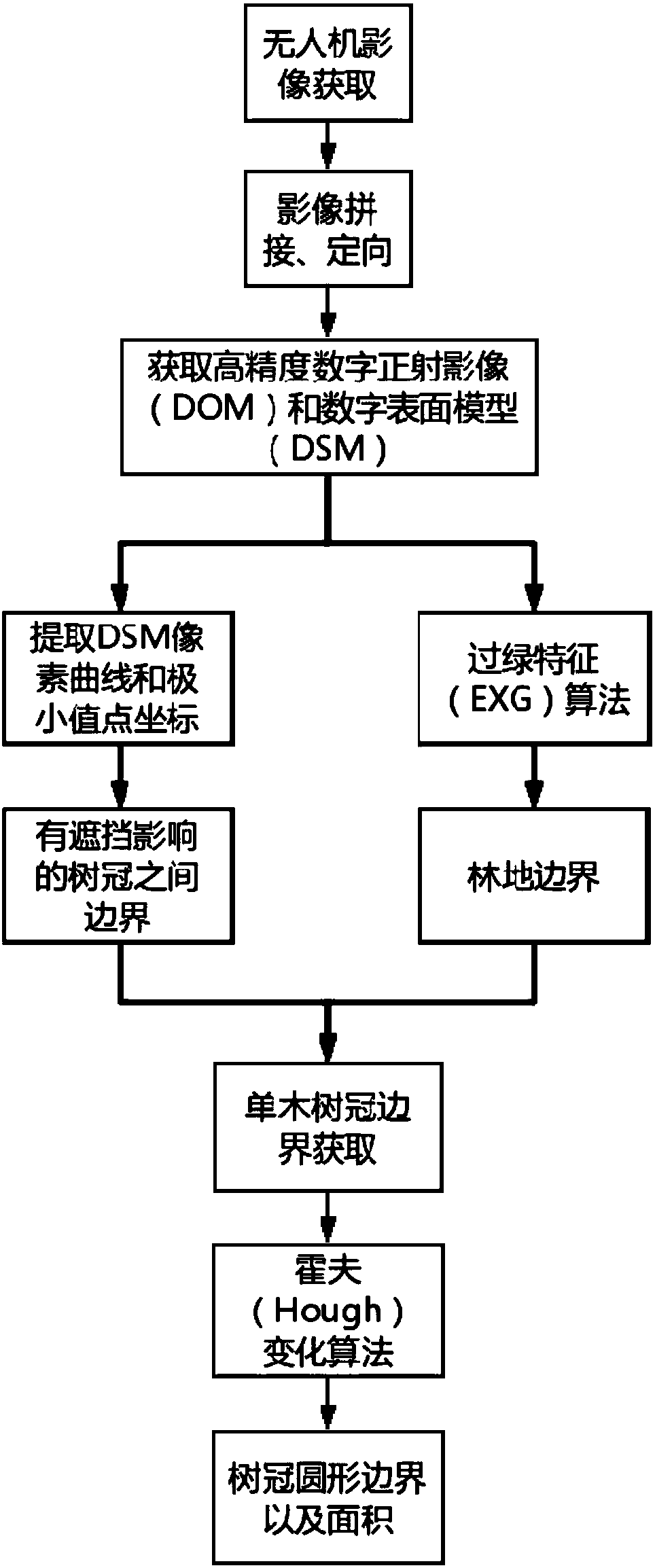
[0023] Specific embodiment one: a kind of high canopy density forest canopy area acquisition method based on unmanned aerial vehicle image comprises the following steps:
[0024] Step 1: Use drones to collect images of forest land, process the images to generate digital orthophoto maps (Digital Orthophoto Map, DOM), digital surface models (digital surface models, DSM) and digital elevation models (Digital elevation models, DEM) );
[0025] Step 2: The digital orthophoto image obtained in step 1 is processed by excess green (EXG) to obtain the forest area image, and the forest area image is processed by Sobel algorithm after binarization and image morphology processing. The sub detects the edge of the woodland;
[0026] Step 3: Perform median filtering on the digital surface model obtained in step 1 to obtain the pixel curves of each row and each column, and take out the minimum value points on the curves to obtain the boundaries between the tree crowns that block each other; ...
specific Embodiment approach 2
[0029] Specific embodiment 2: The difference between this embodiment and specific embodiment 1 is that in the step 1, drones are used to collect images of forest land, and the images are processed to generate digital orthophoto images, digital surface models and digital elevation models. The specific process is:
[0030] Step 11: Import the UAV images into the photogrammetry and modeling software Agisoft photoscan;
[0031] Step 1 and 2: According to the latest multi-view Figure three The three-dimensional reconstruction technology automatically calculates the position and attitude of the photo, and the internal orientation, relative orientation and absolute orientation are all automatically completed. The three-dimensional dense point cloud data with coordinate information is extracted from the original photo data taken by the drone without manual work. Additional intervention. The basic data required are images, pos data and control point data.
[0032] Step 13: Accordin...
specific Embodiment approach 3
[0037] Specific embodiment three: the difference between this embodiment and specific embodiment one or two is that in the step two, the digital orthophoto image obtained in the step one is processed with a super green feature algorithm to obtain a forest area image, and the forest area image is passed through The specific process of using the Sobel operator to detect the edge of the woodland after binarization and image morphology processing is as follows:
[0038] Step 21: According to the xcess green (EXG) feature index, the digital orthophoto image obtained in step 1 is grayscaled. The formula of the xcess green feature index is:
[0039] EXG=2ρ green -ρ red -ρ blue
[0040] Wherein said EXG is calculated to obtain the super green characteristic index value of the pixel point, ρ green ,ρ red ,ρ blue Respectively represent the reflection values of the three bands of green, red and blue;
[0041] Step 22: Binarize the grayscale image obtained after being processed b...
PUM
 Abstract
Description
Claims
Application Information
 - R&D
- Intellectual Property
- Life Sciences
- Materials
- Tech Scout
- Unparalleled Data Quality
- Higher Quality Content
- 60% Fewer Hallucinations
Browse by: Latest US Patents, China's latest patents, Technical Efficacy Thesaurus, Application Domain, Technology Topic, Popular Technical Reports.
© 2025 PatSnap. All rights reserved.Legal|Privacy policy|Modern Slavery Act Transparency Statement|Sitemap|About US| Contact US: help@patsnap.com