Fusion method of multi-source ocean surface temperature remote sensing products based on a robust fixed-order filter model

A technology of remote sensing products and surface temperature, applied in character and pattern recognition, instruments, calculations, etc., can solve problems such as insufficient use of prior knowledge, impact on product accuracy, and large calculation rate

Active Publication Date: 2020-10-30
HUAIYIN TEACHERS COLLEGE
View PDF5 Cites 0 Cited by
  • Summary
  • Abstract
  • Description
  • Claims
  • Application Information

AI Technical Summary

Problems solved by technology

In the time series reconstruction algorithm of remote sensing products based on time filtering, there are mainly the following problems: lack of utilization of the dynamic process model of remote sensing parameters; insufficient use of historical prior knowledge; no definition and definition of data uncertainty during time series reconstruction. Quantification; spatial heterogeneity is not considered; in the calculation process of most methods, the determination of the time window is affected by subjective experience, and there is a large uncertainty in the choice of noise and real information, so the accuracy of the filtered product is affected by certain influence
Although the spatial filtering method fully considers the spatial heterogeneity, there are still the following problems: the spatial filtering performs interpolation according to the spatial relationship of the pixel neighborhood, without considering the dependence of the time dynamic process between the data, and due to the optimal unbiased estimation condition The variance of the spatial interpolation is lower than that of the original data, which has an obvious smoothing effect, and the local spatial detail information is not easy to maintain; affected by the density of the observed data, the spatial interpolation error is large in large areas of missing data; limited by the covariance inversion , it is difficult to achieve efficient calculation of large amounts of data, although the FRK and FRF methods achieve spatial dimensionality reduction through multi-resolution wavelet basis functions, solve the calculation problem of large data volume covariance inversion in traditional geostatistical methods, and have high computational efficiency , but the problem that the data after spatiotemporal interpolation is too smooth has not been solved, and these two methods are for spatiotemporal interpolation in irregular areas such as SST, and the calculation of multi-variable wavelet basis functions is unstable, which needs to be improved
However, this method uses the space-time covariance model to realize the space-time time difference, which has a large calculation rate problem, and it is difficult to combine with the space-time process model

Method used


Image

  • Fusion method of multi-source ocean surface temperature remote sensing products based on a robust fixed-order filter model
  • Fusion method of multi-source ocean surface temperature remote sensing products based on a robust fixed-order filter model
  • Fusion method of multi-source ocean surface temperature remote sensing products based on a robust fixed-order filter model

Examples


Embodiment

[0104] This algorithm has been successfully applied to the fusion of MODIS map SST products and AMSR-E map SST data.

[0105] MODIS map SST product: spatial resolution: 4km; temporal resolution: 8-day synthesis;

[0106] AMSR-E map SST product: spatial resolution: 25km; temporal resolution: daily data;

[0107] Fused data products: spatial resolution: 4km; temporal resolution: 8-day synthesis;

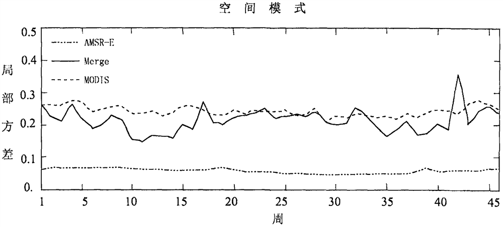
[0108] Comparison of spatial integrity of MODIS map SST products, AMSR-E map SST products and fused data products:

[0109] The annual average effectiveness of AMSR-E SST is 87.53%, MODIS SST is 80.38%, and the hierarchical Bayesian fusion SST based on the robust fixed-order filtering process model is 100%, achieving full coverage of ocean pixels ( figure 1 ).

[0110] The accuracy of fusion SST is closer to MODIS SST, but it is higher than MODIS SST and lower than AMSR-E SST. The absolute average deviation is 0.2205°C lower than MODIS and 0.0952°C higher than AMSR-E; AMSR-E is 0.2...


PUM


Abstract

The invention discloses a multi-source sea surface temperature (SST) remote sensing product fusion method based on a robust fixed-order filter model, which integrates the scale conversion problem in the time-space fusion process of SST remote sensing products, the product uncertainty expression problem and SST The complex spatial structure and time structure of the spatio-temporal process make full use of the complementary characteristics of remote sensing products in terms of spatial resolution, spatio-temporal integrity, and precision features, and adopt a hierarchical Bayesian framework based on a robust fixed-order filtering process model to fuse infrared SST and microwave SST remote sensing products to obtain fine-scale fusion data with high precision, complete space, and rich local spatial patterns. The simulation of SST spatial trends in the present invention is more reasonable, and realizes seamless time-space scale conversion among multi-source remote sensing products, Quantification of uncertainty in remote sensing products is suitable for efficient calculation of large amounts of remote sensing data.

Description

technical field [0001] The invention relates to the technical field of marine remote sensing, in particular to a fusion method of multi-source ocean surface temperature remote sensing products based on a robust fixed-order filter model. Background technique [0002] Sea surface temperature is one of the important parameters in the global air-sea coupling system. It plays the most basic role in the exchange of energy and water vapor between the ocean and the atmosphere. It has been widely used in upper ocean processes, climate change detection, In the research of sea-air heat exchange, ocean-atmosphere numerical simulation and forecast, and ocean-atmosphere assimilation model. [0003] At present, the means of obtaining SST mainly include traditional on-site observation and modern remote sensing observation. Traditional on-site observations are mainly made through conventional observation systems such as ships, fixed and drifting buoys at sea, and offshore observation platfo...

Claims


Application Information

Patent Timeline
Patent Type & Authority Patents(China)
IPC IPC(8): G06K9/62
CPCG06F18/25
Inventor 朱瑜馨柏延臣康蕾张锦宗
Owner HUAIYIN TEACHERS COLLEGE
Why Eureka
Try Eureka