
Multi-temporal Hyperspectral Image Classification Method Preserving Global Geometry Structure Based on Spatial Spectral Features

A hyperspectral image and geometric structure technology, which is applied in the directions of instruments, computing, character and pattern recognition, etc., can solve problems such as wrong spectral neighbors, unreliable spectral similarity of image data, information redundancy data processing complexity, etc.

Active Publication Date: 2019-06-11
黑龙江省工研院资产经营管理有限公司
View PDF4 Cites 0 Cited by
  • Summary
  • Abstract
  • Description
  • Claims
  • Application Information

AI Technical Summary

Problems solved by technology

[0003] Multi-temporal hyperspectral data classification mainly faces three main problems: 1. The number of bands continues to increase, resulting in information redundancy and increased data processing complexity; 2. It is very difficult to obtain labeled samples of hyperspectral images and requires a large amount of Manpower, material resources and time-consuming; 3. There may be spectral drift in multi-temporal hyperspectral images, resulting in unreliable spectral similarity of image data from different temporal phases
These are all methods of maintaining the local geometric structure of the data, but this method is sometimes not applicable, for example, for highly folded data, it may bring wrong spectral neighbors and affect the classification effect

Method used


Image

  • Multi-temporal Hyperspectral Image Classification Method Preserving Global Geometry Structure Based on Spatial Spectral Features
  • Multi-temporal Hyperspectral Image Classification Method Preserving Global Geometry Structure Based on Spatial Spectral Features
  • Multi-temporal Hyperspectral Image Classification Method Preserving Global Geometry Structure Based on Spatial Spectral Features

Examples


specific Embodiment approach 1

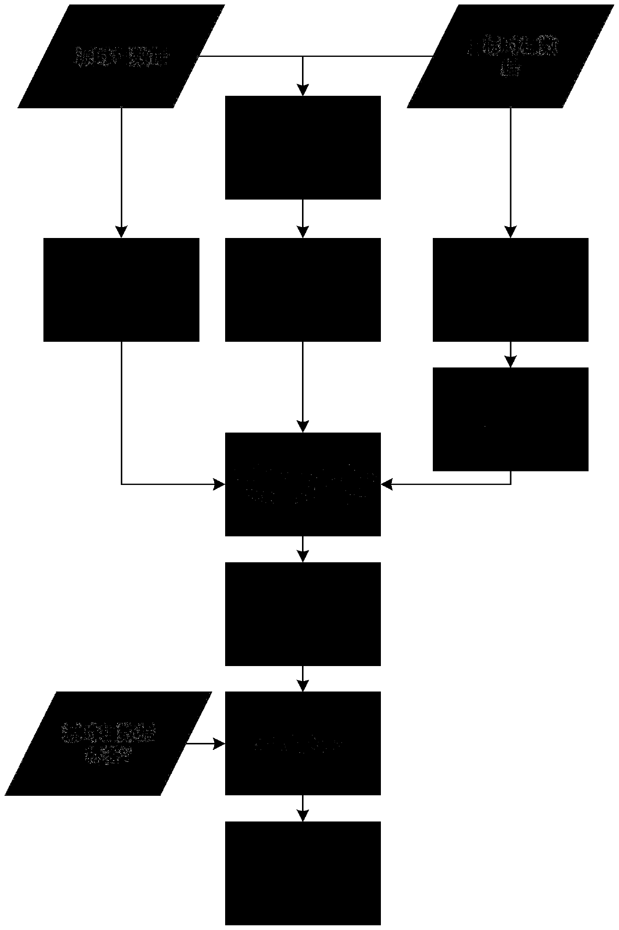
[0025] Specific implementation mode one: combine figure 1 Describe this embodiment, the multi-temporal hyperspectral image classification method based on spatial spectral features to maintain global geometric structure in this embodiment, the specific process is:

[0026] Step 1. Input the spectral matrix X of the samples in the source image and the target image s 、X t and x s 、X t The space coordinate Z 1 ,Z 2 , and X s The corresponding category label vector Y for each row;

[0027] Step 2. Calculate X s 、X t For each type of sample in the source image, select k samples with the smallest spatial spectral distance in the target image as the data pairs that need to be matched;

[0028] Step 3. Calculate X s ,X t The geodesic distance matrix D s,s ,D t,t , and use the data pair to calculate the distance matrix D between the source image and the target image s,t , adjust X s ,X t scale, with D s,s 、D t,t 、D s,t Build a distance matrix D;

[0029] Step 4, put ...

specific Embodiment approach 2

[0031] Specific embodiment two: the difference between this embodiment and specific embodiment one is: the calculation of X in the second step s 、X t The spatial spectral distance d, each type of sample in the source image selects k samples with the smallest spatial spectral distance in the target image as the data pairs that need to be matched; the specific process is:

[0032]

[0033]

[0034] d=d spectral d spatial

[0035] where d spectral and d spatial Represents the Gaussian similarity measure of the source image and the target image on the spectrum and space, respectively, x s i Indicates the i-th sample of the source image, z s i Indicates the spatial coordinates of the i-th sample of the source image, x t j Indicates the jth sample of the target image, z t j Indicates the spatial coordinates of the jth sample of the target image, σ spectral ,σspatial Represent the Gaussian weight parameters on the spectrum and space respectively; the value ranges o...

specific Embodiment approach 3

[0038] Embodiment 3: This embodiment differs from Embodiment 1 or Embodiment 2 in that: the number of categories C is 7, and k is 1-20.

[0039] Other steps and parameters are the same as those in Embodiment 1 or Embodiment 2.


PUM


Abstract

The invention relates to a multi-temporal hyperspectral image classification method for maintaining global geometric structure based on spatial spectral features, and the invention relates to a multi-temporal hyperspectral remote sensing image classification method. The purpose of the present invention is to solve the problem that it is difficult to obtain hyperspectral multi-temporal data tags and the image has obvious spectral drift, and the problem of unreliable classification of target time-phase data by directly using the hyperspectral data of the source time-phase. The specific process is: 1. Input X s with X t and their spatial coordinates Z 1 ,Z 2 , and X s The corresponding category label vector Y for each row; 2. Calculate X s ,X t The space spectrum distance selects the nearest point as the data pair that needs to be matched; 3. Calculate D s,s ,D t,t and D s,t , adjust the scale of the data set, and construct the distance matrix D; 4. Obtain X s , of the mapping matrices α and β in the alignment space, so that the projection f s and f t ; Five, use f s and f t and f s The corresponding label Y is classified by the KNN classification model to obtain the classification label of the target phase. The invention is used in the field of image classification.

Description

technical field [0001] The invention relates to a multitemporal hyperspectral image classification method. Background technique [0002] With the development of optical sensors and spectroscopic technology, hyperspectral remote sensing imaging technology has developed rapidly on the basis of multispectral remote sensing imaging technology. Hyperspectral imaging technology combines imaging technology and spectral technology, and can simultaneously record the spatial structure information and rich spectral information of the area to be detected, and with the development of remote sensing technology, it can now provide large-area areas with spatial and temporal sequence Hyperspectral multi-temporal image data for ground object perception and monitoring. Multi-temporal hyperspectral images make multi-temporal analysis, multi-angle research, and accurate ground object change detection possible. However, it is unrealistic to provide sufficient label information for each phase ma...

Claims


Application Information

Patent Timeline
Patent Type & Authority Patents(China)
IPC IPC(8): G06K9/62
CPCG06F18/24147
Inventor 谷延锋张美玲
Owner 黑龙江省工研院资产经营管理有限公司
Learn More