
Mountain area point cloud filtering method

A point cloud and mountainous technology, applied in image data processing, 3D modeling, instruments, etc., can solve problems such as misclassification and wrong encryption order

Active Publication Date: 2017-01-18
CHINA TOPRS TECH
View PDF5 Cites 13 Cited by
  • Summary
  • Abstract
  • Description
  • Claims
  • Application Information

AI Technical Summary

Problems solved by technology

When the terrain has large fluctuations, the terrain feature points may be misclassified due to the wrong encryption order

Method used


Image

  • Mountain area point cloud filtering method
  • Mountain area point cloud filtering method
  • Mountain area point cloud filtering method

Examples


Embodiment Construction

[0052] In order to make the purpose, technical solutions and advantages of the embodiments of the present invention clearer, the technical solutions in the embodiments of the present invention will be clearly and completely described below in conjunction with the drawings in the embodiments of the present invention. Obviously, the described embodiments are only It is a part of embodiments of the present invention, but not all embodiments. The components of the embodiments of the invention generally described and illustrated in the figures herein may be arranged and designed in a variety of different configurations. Accordingly, the following detailed description of the embodiments of the invention provided in the accompanying drawings is not intended to limit the scope of the claimed invention, but merely represents selected embodiments of the invention. Based on the embodiments of the present invention, all other embodiments obtained by those skilled in the art without making...


PUM


Abstract

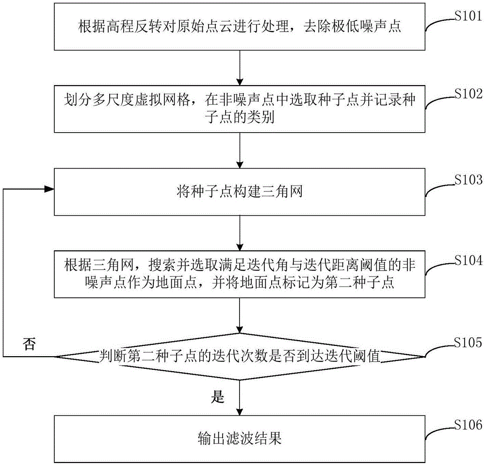
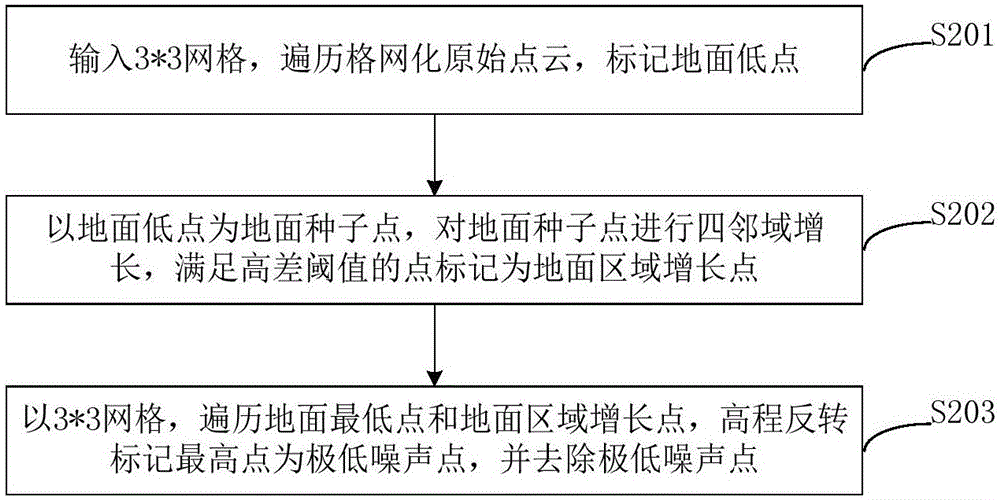
The invention provides a mountain area point cloud filtering method. The mountain area point cloud filtering method comprises steps that original point cloud is processed according to elevation inversion to remove extreme low noise points; a multi-dimensioned virtual grid is divided, seed points are selected from non-noise points, and categories of the seed points are recorded; the seed points form a triangle net; according to the triangle net, the non-noise points satisfying an iteration angle and an iteration distance are searched and selected as ground points, and the ground points are marked as second seed points; whether the iteration times of the second seed points reaches an iteration threshold is determined; if the iteration times of the second seed points does not reach the iteration threshold, the seed points are continuously utilized to form a triangle net; if the iteration times of the second seed points reaches the iteration threshold, a filtering result is outputted. Through the method, the data structure is simple, management and calling are convenient, the filtering effect is effectively improved, and the landform information is guaranteed to be realer and more complete.

Description

technical field [0001] The invention relates to the technical field of digital aerial photogrammetry, in particular to a point cloud filtering method in mountainous areas. Background technique [0002] With the continuous development and improvement of laser ranging technology, airborne LiDAR (Light Detection AndRanging, LiDAR) can quickly obtain high-precision three-dimensional surface information. The original point cloud contains ground points and non-ground points. Using LiDAR data combined with various filtering methods to separate ground points and non-ground points in the original point cloud is the key to obtaining DEM of complex urban areas. Due to the complexity and diversity of terrain and ground objects, point cloud filtering is still in the research and development stage. [0003] At present, the commonly used point cloud filtering methods include mathematical morphology filtering, slope filtering, iterative least squares interpolation and irregular triangulate...

Claims


Application Information

Patent Timeline
IPC IPC(8): G06T17/05G06T17/20
Inventor 李英成崔继祥刘晓龙朱祥娥罗祥勇刘飞
Owner CHINA TOPRS TECH
Learn More