


Quick Research
Generate reliable direction feasibility study reports for your R&D in just a few steps.

Technical Q&A
Discover and master advanced knowledge NOW. Basics, ideas, possibilities, all at once.

Find Solutions
As an expert in R&D theories, this can generate solutions to your technical problems instantly.

Evaluate Feasibility
Analyze your overall solution with one click, know your potential R&D risks in advance.

Monitor Landscape
Get weekly tech updates, stay abreast of the latest tech innovations and key insights.
Urban virtual road drawing method and device thereof
A technology of virtual roads and cities, applied in the field of intelligence, can solve the problems of information loss, high cost of map drawing, security impact, etc., to reduce the consumption of human and material resources, improve the efficiency of real-time update, and ensure the accuracy.
- Summary
- Abstract
- Description
- Claims
- Application Information
AI Technical Summary
Problems solved by technology
Method used
Image

Examples
Embodiment 1
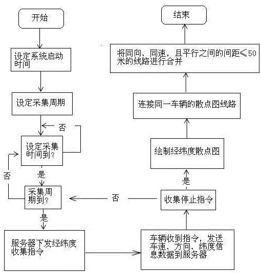
[0018] combine figure 1 As shown, the virtual road drawing is drawn for the virtual road conditions in a specific time period. First, a GPS locator and a wireless transceiver device need to be installed on the vehicle, and the specific time period of the system is set to 7:00-9:00 in the morning , 11:00-14:00 noon and 17:00-19:00 p.m., three peak time periods with large traffic flow, when the set time is up, the server issues a "start" command, and the "start" command Through the 3G wireless network, it is transmitted to the wireless transceiver device on the vehicle, and then the wireless transceiver device transfers the received instructions to the GPS locator. The GPS locator performs data collection according to the parameters of the set collection time and collection cycle. The GPS positioning on the vehicle The instrument locates the vehicle, and collects the latitude and longitude information of the positioning point during the driving process of the vehicle and the inf...
Embodiment 2
[0020] The virtual road drawing is drawn for the virtual road conditions in a specific time period. First, a GPS locator and a wireless transceiver device need to be installed on the vehicle, and the specific time period of the system is set to 7:00-9:00 in the morning and 11 at noon. :00-14:00 and 17:00-19:00 p.m., three peak time periods with large traffic flow, when the set time is up, the server will issue a "start" command, and the "start" command will be sent through 2G wireless The network is transmitted to the wireless transceiver device on the vehicle, and then the wireless transceiver device transfers the received instructions to the GPS locator. The GPS locator performs data collection according to the parameters of the set collection time and collection cycle. Carry out positioning, and collect the longitude and latitude information of the positioning point during the vehicle's driving process and the information data of the vehicle's driving speed. When the set tim...
Embodiment 3
[0022] The virtual road drawing is drawn for the virtual road conditions in a specific time period. First, a GPS locator and a wireless transceiver device need to be installed on the vehicle, and the specific time period of the system is set to 7:00-9:00 in the morning and 11 at noon. :00-14:00 and 17:00-19:00 p.m., three peak time periods with large traffic flow, when the set time is up, the server will issue a "start" command, and the "start" command will pass through 4G wireless The network is transmitted to the wireless transceiver device on the vehicle, and then the wireless transceiver device transfers the received instructions to the GPS locator. The GPS locator performs data collection according to the parameters of the set collection time and collection cycle. Carry out positioning, and collect the longitude and latitude information of the positioning point during the vehicle's driving process and the information data of the vehicle's driving speed. When the set time i...
PUM
 Abstract
Description
Claims
Application Information
 - R&D Engineer
- R&D Manager
- IP Professional
- Industry Leading Data Capabilities
- Powerful AI technology
- Patent DNA Extraction
Browse by: Latest US Patents, China's latest patents, Technical Efficacy Thesaurus, Application Domain, Technology Topic, Popular Technical Reports.
© 2024 PatSnap. All rights reserved.Legal|Privacy policy|Modern Slavery Act Transparency Statement|Sitemap|About US| Contact US: help@patsnap.com