A Method of Generating Map Tile Coordinates Along Trajectories

A technology for generating maps and trajectory lines, applied in geographic information databases, instruments, program control design, etc., can solve the problems of downloading resources, waste of local storage space, and low utilization rate of map tile data, so as to reduce the number of downloaded map tiles The number of chips, saving local storage space, and improving user experience

Active Publication Date: 2019-04-02
成都新橙北斗智联有限公司
View PDF6 Cites 0 Cited by
  • Summary
  • Abstract
  • Description
  • Claims
  • Application Information

AI Technical Summary

Problems solved by technology

[0002] Applications based on location services generally use online network map tile data for map display when connected to the network. To display a map without a network, you need to download the online map tile data to the local; download the map The tile method is usually to select a rectangular area to download. This method is relatively simple to implement, but its map tile data utilization rate is too low. The map tile data in many areas is redundant in practical applications, and application users do not care That part of map tile data caused a waste of download resources and local storage space

Method used


Image

  • A Method of Generating Map Tile Coordinates Along Trajectories
  • A Method of Generating Map Tile Coordinates Along Trajectories
  • A Method of Generating Map Tile Coordinates Along Trajectories

Examples


Embodiment Construction

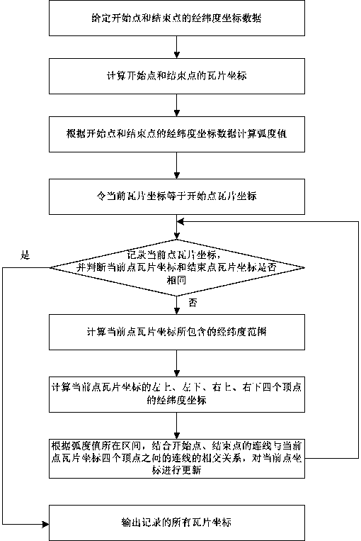
[0072] The technical solution of the present invention will be further described in detail below in conjunction with the accompanying drawings, but the protection scope of the present invention is not limited to the following description.

[0073] like figure 1 As shown in , a method for generating map tile coordinates along a trajectory line includes the following steps:

[0074] S1. Longitude and latitude coordinate data of a given start point and end point;

[0075] S2. Calculate the tile coordinates of the start point and the end point (that is, the row and column coordinates in the tile coordinate system);

[0076] S3. Calculate the radian value according to the latitude and longitude coordinate data of the start point and the end point;

[0077] S4. Make the current tile coordinates equal to the starting point tile coordinates;

[0078] S5. Record the tile coordinates of the current point, and judge whether the tile coordinates of the current point and the end point a...


PUM


Abstract

The invention discloses a method for generating a map tile coordinate along a trajectory. The method comprises the following steps: S1: giving the longitude and latitude coordinate data of a start point and an end point; S2: calculating a start point tile coordinate and an end point tile coordinate; S3: calculating a radian value; S4: causing a current point tile coordinate to be equal to the start point tile coordinate; S5: recording a current point tile coordinate, judging whether the current point tile coordinate is the same with the end point tile coordinate or not, jumping to S9 if the current point tile coordinate is the same with the end point tile coordinate, and otherwise, entering S6; S6: calculating a longitude and latitude range contained in the current point tile coordinate; S7: according to the longitude and latitude range, successively calculating the current point tile coordinate; S8: updating the current point tile coordinate, and returning to S5; and S9: outputting all recorded tile coordinates. By use of the method, the map tile coordinate is obtained along the trajectory, and downloading time and the number of downloaded map tiles can be greatly reduced if the method is used for downloading map data. In practical application, user experience can be greatly improved, and a great quantity of local storage time can be saved.

Description

technical field [0001] The invention relates to a method for generating map tile coordinates along trajectory lines. Background technique [0002] Applications based on location services generally use online network map tile data for map display when connected to the network. To display a map without a network, you need to download the online map tile data to the local; download the map The tile method is usually to select a rectangular area to download. This method is relatively simple to implement, but its map tile data utilization rate is too low. The map tile data in many areas is redundant in practical applications, and application users do not care That part of the map tile data caused a waste of download resources and local storage space. Contents of the invention [0003] The purpose of the present invention is to overcome the deficiencies of the prior art, provide a method for generating map tile coordinates along the trajectory, realize the acquisition of map ti...

Claims


Application Information

Patent Timeline
Patent Type & Authority Patents(China)
IPC IPC(8): G06F16/29G06F9/445
CPCG06F9/44578G06F16/29
Inventor 李祥明园雷子钒
Owner 成都新橙北斗智联有限公司
Why Eureka
Try Eureka