
Building corner space position automatic extraction method in vehicle laser scanning point cloud

A vehicle-mounted laser scanning and laser scanning technology is applied in the field of automatic extraction of building corner spatial positions in vehicle-mounted laser scanning point clouds. Extraction effect, highly automated effect

Active Publication Date: 2016-10-26
SHANDONG UNIV OF SCI & TECH
View PDF3 Cites 16 Cited by
  • Summary
  • Abstract
  • Description
  • Claims
  • Application Information

AI Technical Summary

Problems solved by technology

The building corner extraction methods based on the vehicle-mounted mobile laser measurement system mainly include projection image method, feature clustering and scan line method. Influence of Noise Points in Laser Scanning Point Cloud Data

Method used


Image

  • Building corner space position automatic extraction method in vehicle laser scanning point cloud

Examples


Embodiment Construction

[0041] The basic idea of ​​the present invention is to propose a vehicle-mounted laser scanning point cloud by studying the point-based plane projection image generated by the point cloud, using image processing, and combining the geometry and characteristics of building walls and corner points. Automatic extraction method of spatial position of building corners in cloud.

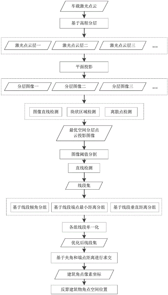
[0042] combine figure 1 As shown, the method for automatically extracting the spatial position of building corners in the vehicle-mounted laser scanning point cloud includes the following steps:

[0043] a. According to the height of the local building, the spatial layered point cloud data in the vertical direction within the local range is automatically obtained, and the spatial layered point cloud is plane projected; according to the range of the spatial layered point cloud and the spatial layered point cloud Plane coordinates project the discrete vehicle-mounted laser scanning point cloud onto the plane...


PUM


Abstract

The present invention discloses a building corner space position automatic extraction method in a vehicle laser scanning point cloud. The method comprises: obtaining the space layering point cloud in a vehicle direction in a local range according to the height of a local building, performing planar projection of the space layering point cloud, and projecting the dispersed laser scanning point cloud to a plane according to the range of the space layering point cloud and the plane coordinates of the space layering point cloud; defining the brightness value of a pixel according to the number of the laser scanning point cloud in a unit pixel on the plane, converting the brightness value of the pixel to a planar projection image; performing linear detection of an area having high brightness in the plane projection image, extracting the line sections having linear features, and merging the line sections; and analyzing the relative position relation and the intersecting angle of the extracted line sections, screening out the line sections which accord with the building corner features through intersecting, solving the coordinates of the line section intersecting corner points in the planar projection image, and calculating the space position information of a corner object according to the coordinates of the line section intersecting corner points in the planar projection image.

Description

technical field [0001] The invention belongs to the technical field of vehicle-mounted laser scanning point cloud data processing, and in particular relates to a method for automatically extracting spatial positions of building corners in a vehicle-mounted laser scanning point cloud. Background technique [0002] The measurement of building corners is one of the important tasks in the survey of topographic maps and cadastral maps. At present, the location information of building corners is mainly obtained through traditional manual measurement methods. The update cycle is long and resource consumption is large, which can no longer meet the requirements of urban construction and management. data requirements. As an advanced measurement method, the vehicle-mounted mobile laser measurement system has the characteristics of fast, non-contact with the measurement object, real-time, dynamic, active, high density and high precision. The building corner extraction methods based on ...

Claims


Application Information

Patent Timeline
Patent Type & Authority Applications(China)
IPC IPC(8): G06T15/00G06T7/00
CPCG06T15/005G06T2210/04
Inventor 刘如飞田茂义卢秀山刘甜曲杰卿侯海龙
Owner SHANDONG UNIV OF SCI & TECH
Learn More