BIM-based water conservancy and hydropower project management cloud platform and application method thereof
A technology of engineering management, water conservancy and hydropower, applied in data processing applications, instruments, calculations, etc., can solve problems such as low collaboration efficiency, information loss, and cross-effects of problems, and achieve the goal of maintaining timeliness, clarity, and integrity Effect
- Summary
- Abstract
- Description
- Claims
- Application Information
AI Technical Summary
Problems solved by technology
Method used
Image
Examples
Embodiment 1
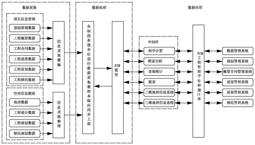
[0047] Embodiment 1: A BIM-based water conservancy and hydropower project management cloud platform, see figure 1 ,include:
[0048] Data acquisition layer, data acquisition layer includes project information management and spatial information measurement, project information management is used to collect project management information, and spatial information measurement is used to collect spatial measurement information. Project information management includes basic data management, engineering budget data, engineering contract data, engineering progress data, engineering quality data, and engineering resettlement data; the spatial information measurement includes terrain data, engineering design data, engineering planning data, and resettlement planning data.
[0049] Communication network layer, the communication network layer includes local area network, VPN private network or public network,
[0050] Data resource layer, the data resource layer includes BIM models, stor...
Embodiment 2
[0054] Embodiment 2: An application method of a BIM-based water conservancy and hydropower project management cloud platform, see figure 2 , including data acquisition, data processing and data application.
[0055] Data collection: including project management information and spatial measurement information collected from the construction site and construction participants. Project management information includes basic management data, project budget data, project contract data, project progress data, project quality data, and project resettlement data, etc. information. Spatial measurement information includes terrain data, engineering design data, engineering planning data, and resettlement planning data. The collected data is reorganized or arranged by the construction participants and sent to the BIM model in the data resource layer through the local area network, VPN private network or public network. Spatial measurement information of hydraulic engineering or other p...
Embodiment 3
[0062] Embodiment 3: Embodiment 3 is basically the same as Embodiment 2, and the similarities will not be repeated. The difference is that the BIM engineering management platform also includes a simulation calculation BIM model, and the establishment of the simulation calculation BIM model includes the following steps:
[0063] (1) Based on the automatic acquisition of monitoring data during the construction period: through various hardware equipment and software analysis systems that meet the real working performance analysis of the dam, and through big data technology, the automatic analysis of massive data can be realized to meet the requirements of numerical simulation;
[0064] (2) Establishment of the numerical simulation model for the whole process of the whole dam: establish a numerical simulation analysis model of the whole process of the whole dam based on the cloud platform architecture, and the simulation model considers the whole process of complex foundation faults...
PUM
 Abstract
Description
Claims
Application Information
 - R&D
- Intellectual Property
- Life Sciences
- Materials
- Tech Scout
- Unparalleled Data Quality
- Higher Quality Content
- 60% Fewer Hallucinations
Browse by: Latest US Patents, China's latest patents, Technical Efficacy Thesaurus, Application Domain, Technology Topic, Popular Technical Reports.
© 2025 PatSnap. All rights reserved.Legal|Privacy policy|Modern Slavery Act Transparency Statement|Sitemap|About US| Contact US: help@patsnap.com


