
Method for applying mobile base station to enhance positioning effect in network RTK

A mobile reference station and enhanced positioning technology, which is applied in the field of global navigation system and positioning measurement, can solve the problems of affecting the positioning service of positioning users, increasing the distance of network RTK base stations, and the failure of normal use of reference stations, so as to improve positioning accuracy and reliability performance, ensure positioning accuracy and reliability, and shorten the distance between base stations

Inactive Publication Date: 2016-06-29
WUHAN UNIV
View PDF4 Cites 24 Cited by
  • Summary
  • Abstract
  • Description
  • Claims
  • Application Information

AI Technical Summary

Problems solved by technology

However, due to the vast territory of our country, the ionospheric activity in some low-latitude areas is extremely active during the day, making the original network RTK technology unable to effectively reduce the impact of ionospheric delay on positioning, which in turn caused the original network RTK system to have abnormal ionospheric activities. Unable to provide users with stable and reliable positioning services
In addition, in the actual application of network RTK, the base station may not be able to use normally due to power failure, receiver failure, network interruption, geological disasters, location changes, etc. The positioning service of the network RTK system for positioning users near the station

Method used


Image

  • Method for applying mobile base station to enhance positioning effect in network RTK
  • Method for applying mobile base station to enhance positioning effect in network RTK
  • Method for applying mobile base station to enhance positioning effect in network RTK

Examples


Embodiment Construction

[0017] In order to facilitate those of ordinary skill in the art to understand and implement the present invention, the present invention will be described in further detail below in conjunction with the accompanying drawings and embodiments. It should be understood that the implementation examples described here are only used to illustrate and explain the present invention, and are not intended to limit this invention.

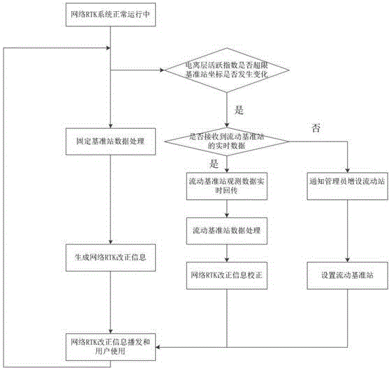
[0018] The present invention provides a method for using mobile reference stations in network RTK to enhance the positioning effect. A mobile reference station is set up in the center of the area, and the atmospheric correction information of the area is obtained by processing the GNSS observation data obtained by the mobile reference station, thereby improving and ensuring the positioning accuracy, reliability and availability of the network RTK system positioning users . The general flow chart is as follows figure 1 shown.

[0019] Specifically include t...


PUM


Abstract

The invention discloses a method for using a mobile reference station in network RTK to enhance the positioning effect. When faults such as abnormal ionospheric activities or faults in the reference station in the domain occur within the service range of the network RTK, temporarily set up a mobile reference station in the fault area. The mobile reference station without precise coordinates uses the GNSS observation data obtained by the mobile reference station to obtain and refine the atmospheric correction information of the fault area, and then correct the differential correction information broadcast by the data processing center to mobile users, thereby ensuring network RTK positioning Service accuracy and reliability, improve system availability.

Description

technical field [0001] The invention belongs to the technical field of global navigation system and positioning measurement, in particular, it relates to a method of obtaining accurate atmospheric correction information of the area where the reference station is located by using the GNSS data of the mobile reference station without knowing the precise coordinates of the mobile reference station in advance , and then enhance the positioning accuracy, reliability and availability of network RTK. Background technique [0002] In RTK positioning, distance-related errors including ionospheric delay and tropospheric delay are the main reasons for limiting the effective working distance of RTK positioning in double-difference mode. The network RTK technology models the error area, which greatly weakens the limitation of the distance-related error on the RTK positioning distance, so that the user's positioning distance is improved from within 10-15km of the traditional single-statio...

Claims


Application Information

Patent Timeline
IPC IPC(8): G01S19/45
CPCG01S19/45
Inventor 姚宜斌胡明贤许超钤孔建
Owner WUHAN UNIV
Learn More