Remote sensing sub-pixel mapping method based on spatial distribution characteristics of features

A spatial distribution, sub-pixel technology, applied in the field of geospatial information, can solve the problem of sawtooth effect, difficult to ensure the spatial distribution characteristics of linear ground objects connectivity, etc.

Inactive Publication Date: 2016-03-30
INST OF GEOGRAPHICAL SCI & NATURAL RESOURCE RES CAS
View PDF1 Cites 11 Cited by
  • Summary
  • Abstract
  • Description
  • Claims
  • Application Information

AI Technical Summary

Problems solved by technology

Although the sub-pixel mapping algorithm based on the largest spatial correlation has a good processing effect on surface objects, it will cause the aggregation of point objects when dealing with point objects with heterogeneous distribution characteristics, and When dealing with linear features, it is often difficult to ensure the connectivity and spatial distribution characteristics of linear features, and it is easy to produce "sawtooth effect".

Method used


Image

  • Remote sensing sub-pixel mapping method based on spatial distribution characteristics of features
  • Remote sensing sub-pixel mapping method based on spatial distribution characteristics of features
  • Remote sensing sub-pixel mapping method based on spatial distribution characteristics of features

Examples


Embodiment Construction

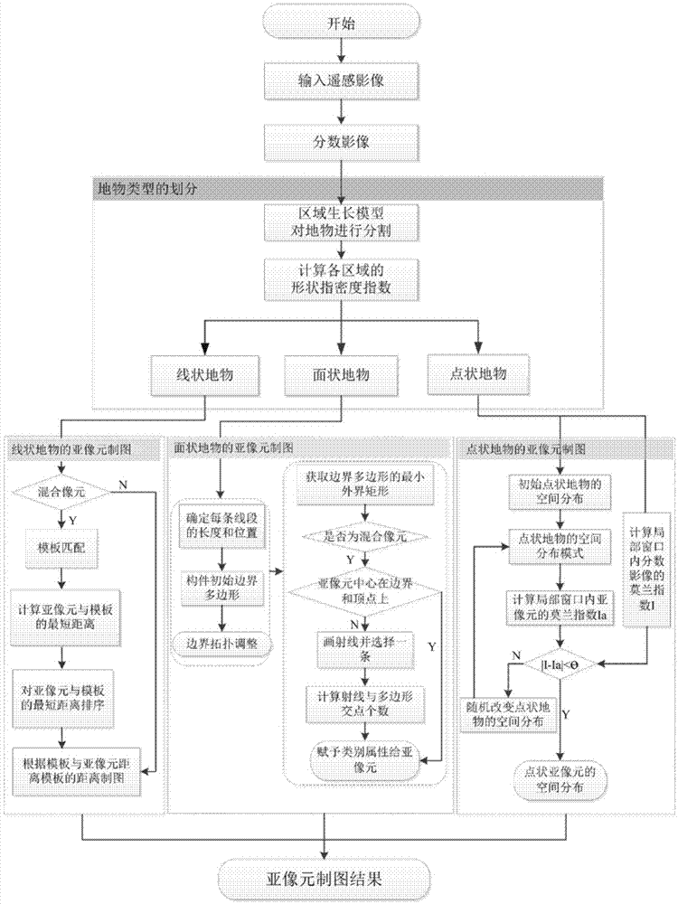
[0048] The present invention will be further described below in conjunction with the accompanying drawings and specific embodiments.

[0049] Such as figure 1 Shown, the concrete implementation process of the present invention is as follows:

[0050] Step 1. Perform geometric correction, atmospheric correction, and denoising preprocessing on the remote sensing image, and then softly classify the real remote sensing image according to the training samples obtained from the field survey to obtain the proportion of various ground object categories in each pixel , that is, the fractional image, which is used as the input data of the present invention. Since errors often exist in the soft classification process, in order to prevent the errors in the soft classification process from affecting sub-pixel mapping, the present invention uses high-resolution images to describe the specific implementation process of sub-pixel mapping. The present invention utilizes the high-resolution ...


PUM


Abstract

The invention discloses a remote sensing sub-pixel mapping method based on the spatial distribution characteristics of features, comprising the following steps: first, classifying remote sensing images into an area pattern, a line pattern and a point pattern according to the spatial geometric characteristics of features; then, under the hypothesis of spatial dependence, using a sub-pixel mapping method based on vector boundary to process area features, using a line feature template sub-pixel mapping method to process line features, and using a sub-pixel mapping method based on space pattern consistency matching to process point features; and finally, embedding the sub-pixel mapping results of the three spatial patterns to get a sub-pixel map of the images. According to the invention, a sub-pixel mapping theoretical model capable of processing point, line and area features at the same time and based on the spatial distribution characteristics of features is built theoretically, and the simulation precision is high.

Description

technical field [0001] The invention relates to a sub-pixel mapping method, which belongs to the technical field of geospatial information. Background technique [0002] Remote sensing science and technology have been widely and deeply applied in fields such as land resource survey, hydrological process simulation, landscape ecology, agricultural yield estimation and disaster monitoring, forestry resource management, global climate change (Mei Anxin, 2001; Zhou Chenghu et al., 1999), high space Remote sensing imagery and its products with high, temporal and spectral resolutions are the development trend for further research and application in various fields (Zhao Yingshi, 2003). However, in the process of remote sensing image acquisition, due to the influence of the external environment and the limitations of the internal sensor itself, mixed pixels (MixedPixel) generally exist in the image, which limits the application of remote sensing images and restricts the extraction o...

Claims


Application Information

Patent Timeline
Patent Type & Authority Applications(China)
IPC IPC(8): G06K9/00G06K9/62G06T7/00
CPCG06T2207/10032G06V20/176G06V20/182G06V20/188G06V20/13G06F18/2411
Inventor 葛咏陈跃红贾远信
Owner INST OF GEOGRAPHICAL SCI & NATURAL RESOURCE RES CAS
Why Eureka
Try Eureka