Geosynchronous orbit circular track SAR imaging method using beam pointing control

A technology of geosynchronous orbit and beam pointing, which is applied in the direction of radio wave reflection/re-radiation, use of re-radiation, radio wave measurement system, etc., can solve the problems of reducing the timeliness of information acquisition and increasing the difficulty of imaging processing, etc., to achieve height change Small, difficulty-reducing effect

Inactive Publication Date: 2016-03-16
INST OF ELECTRONICS CHINESE ACAD OF SCI
View PDF3 Cites 15 Cited by
  • Summary
  • Abstract
  • Description
  • Claims
  • Application Information

AI Technical Summary

Problems solved by technology

When a satellite moves along an elliptical orbit, the height of the satellite orbit and the speed of the satellite relative to the target will change drastically, which increases the difficulty of imaging processing
[0006] Third, in order to realize the imaging of the target by space-borne circular track SAR, the satellite needs to orbit the earth for a complete cycle, which makes the cycle of circular track SAR imaging up to 24 hours, thus reducing the timeliness of information acquisition

Method used


Image

  • Geosynchronous orbit circular track SAR imaging method using beam pointing control
  • Geosynchronous orbit circular track SAR imaging method using beam pointing control
  • Geosynchronous orbit circular track SAR imaging method using beam pointing control

Examples


Embodiment Construction

[0023] Embodiments of the present invention will be described in detail below with reference to the accompanying drawings.

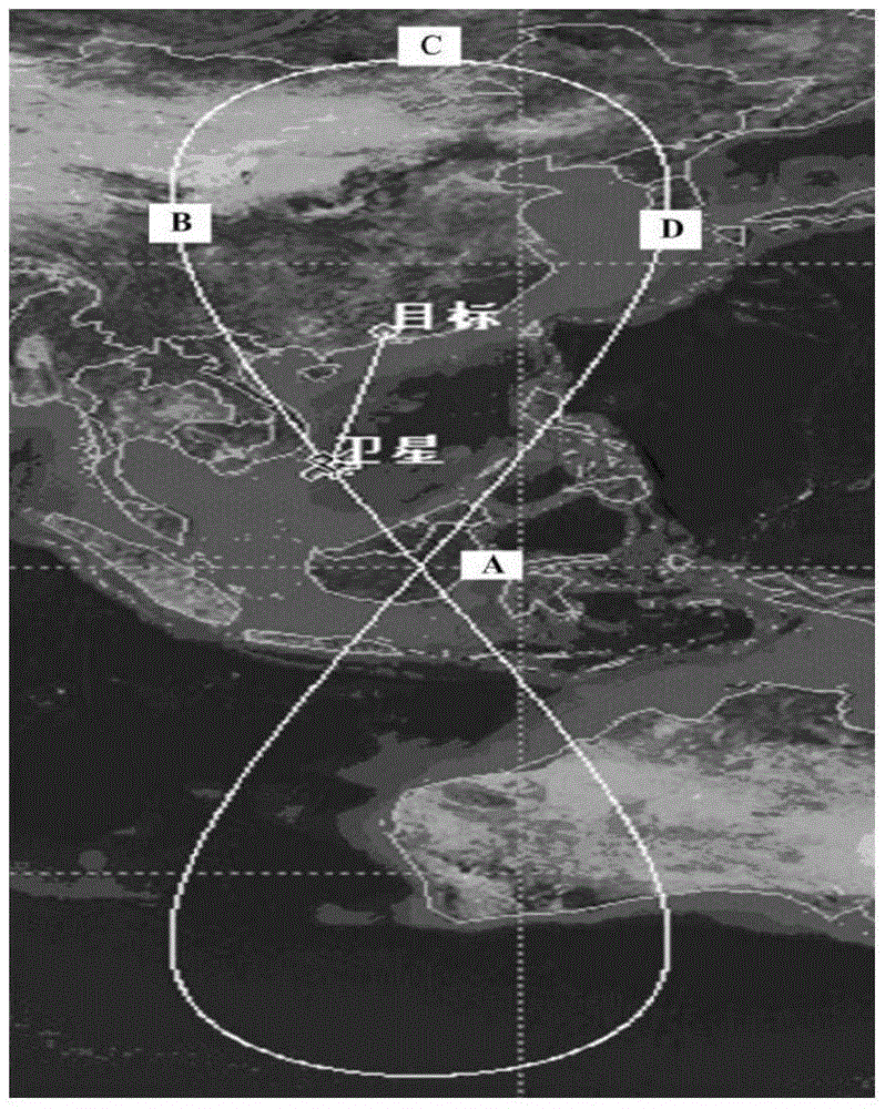
[0024] figure 1 It shows a schematic observation diagram of geosynchronous orbit circular track SAR imaging using beam pointing control according to an embodiment of the present invention. In this embodiment, it is assumed that the target to be imaged and observed is Guangzhou, China, and the center coordinates of the imaging area are 23.0962°N, 113.2936E°.

[0025] According to an embodiment of the present invention, the geosynchronous orbit circular track SAR imaging method using beam pointing control includes the following steps:

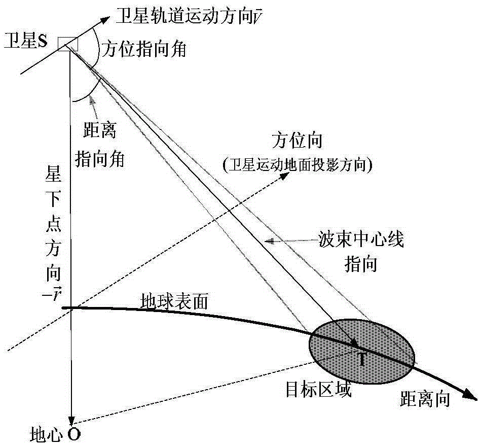
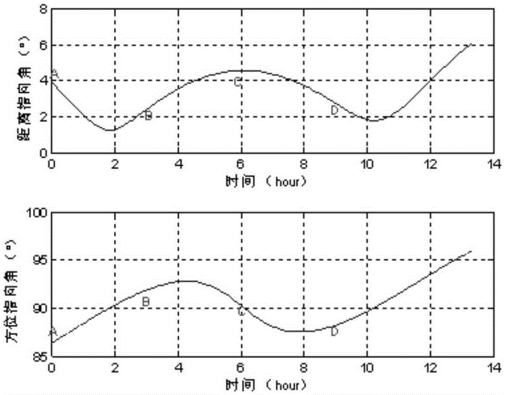
[0026] In the first step, according to the position of the ground target to be observed and imaged, a geosynchronous satellite with zero eccentricity and a “figure-eight” trajectory of the sub-satellite point is selected as the radar platform for circular SAR. The second step is to design orbital parameters such that A ce...


PUM


Abstract

The invention belongs to the technical field of synthetic aperture radar and particularly relates to a geosynchronous orbit circular track SAR imaging method using beam pointing control. By using such a method, a circular track geosynchronous satellite having a 8-shaped sub satellite point locus is taken as a radar platform, 12 hours corresponding to the half 8 shape where an object to be observed is arranged are regarded as an imaging period, the two-dimension antenna wave beam directional control is carried out in the imaging period by means of a stepping technique, so that the satellite can be in the corresponding movement process of the half 8-shaped sub satellite point locus, the antenna wave beam can always point to the imaged ground object to be observed, the 360-degree relative movement of radar relative to the object is formed, and the circular track SAR imaging based on the geosynchronous orbit satellite platform is realized.

Description

technical field [0001] The invention belongs to the technical field of synthetic aperture radar, in particular to a geosynchronous orbit circular track SAR imaging method using beam pointing control. Background technique [0002] Synthetic Aperture Radar (SAR) is an important means of remote sensing observation of earth imaging. Because of its "all-time, all-weather" characteristics, it is not affected by meteorological conditions and night, so it has been widely used. Circular SAR utilizes the relative motion between the radar platform and the observed target to achieve 360° omnidirectional observation of the target, and has many advantages such as high resolution and three-dimensional imaging. At present, circular track SAR often uses airplanes or near-space airships as radar platforms, and realizes circular track imaging through the circular motion of aircraft or airships on ground targets. In terms of space-borne SAR, common imaging satellites are in low orbits and cann...

Claims


Application Information

Patent Timeline
Patent Type & Authority Applications(China)
IPC IPC(8): G01S13/90
CPCG01S13/90G01S13/9058
Inventor 胡文龙江冕
Owner INST OF ELECTRONICS CHINESE ACAD OF SCI
Why Eureka
Try Eureka