
A Vehicle Networking Positioning Method and System Combining External Penalty Method and Steepest Descent Method

A technology of steepest descent method and positioning method, applied in satellite radio beacon positioning system, radio wave measurement system, measurement device and other directions, can solve the problem of low GPS positioning accuracy

Active Publication Date: 2017-04-26
UNIV OF SCI & TECH BEIJING
View PDF4 Cites 0 Cited by
  • Summary
  • Abstract
  • Description
  • Claims
  • Application Information

AI Technical Summary

Problems solved by technology

[0003] The technical problem to be solved by the present invention is to provide a vehicle network positioning method and system combining the external penalty method and the steepest descent method, so as to solve the problem of low GPS positioning accuracy in the vehicle network positioning existing in the prior art

Method used


Image

  • A Vehicle Networking Positioning Method and System Combining External Penalty Method and Steepest Descent Method
  • A Vehicle Networking Positioning Method and System Combining External Penalty Method and Steepest Descent Method
  • A Vehicle Networking Positioning Method and System Combining External Penalty Method and Steepest Descent Method

Examples


Embodiment 1

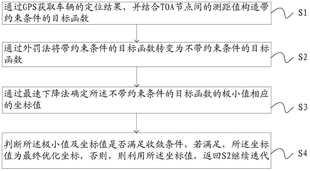
[0073] see figure 1 As shown, the embodiment of the present invention provides a vehicle network positioning method combining the external penalty method and the steepest descent method, including:

[0074] S1, obtain the positioning result of the vehicle through GPS, and combine the ranging value between TOA nodes to construct an objective function with constraints;

[0075] S2, transform the objective function with constraints into an objective function without constraints through the external penalty method;

[0076] S3, determining the coordinate value corresponding to the minimum value of the objective function without constraints by the steepest descent method;

[0077] S4, judging whether the minimum value and the coordinate value meet the convergence condition, if so, the coordinate value is the final optimization coordinate, otherwise, use the coordinate value, return to S2 to continue iteration.

[0078] According to the vehicle networking positioning method combin...

Embodiment 2

[0104] The present invention also provides a specific implementation of the vehicle networking positioning system combining the external penalty method and the steepest descent method. Corresponding to the specific implementation of the vehicle network positioning method combined with the external penalty method and the steepest descent method, the vehicle network positioning system combined with the external penalty method and the steepest descent method can realize the purpose of the present invention by executing the process steps in the specific implementation mode of the above method. Therefore, the above external penalty method The explanations in the specific implementation of the vehicle network positioning method combined with the penalty method and the steepest descent method are also applicable to the specific implementation of the vehicle network positioning system combined with the external penalty method and the steepest descent method provided by the present inven...


PUM


Abstract

The invention provides a vehicle networking positioning method and system based on the combination of an external penalty method and a steepest descent method, helping improving GPS positioning precision. The method comprises: S1, obtaining a vehicle positioning result through a GPS, and constructing an objective function with a constraint condition in combination with distance measuring values among TOA (Time Of Arrival) nodes; S2, converting the objective function with a constraint condition into an objective function without a constraint condition through the external penalty method; S3, determining the corresponding coordinate value of a minimal value of the objective function without a constraint condition through the steepest descent method; and S4, determining whether the minimal value meets a condition of convergence, the coordinate value being a final optimal coordinate if the minimal value meets the condition of convergence, and returning to S2 to continue iteration by utilizing the coordinate value if the minimal value does not meet the condition of convergence. The vehicle networking positioning method and system are suitable for the vehicle networking positioning technical field.

Description

technical field [0001] The invention relates to the technical field of vehicle network positioning, in particular to a vehicle network positioning method and system combining an external penalty method and a steepest descent method. Background technique [0002] In recent years, the Internet of Vehicles positioning system has great application value and market potential, and is usually used for intelligent management in the field of transportation, such as intelligent bus positioning, intelligent parking lot management, vehicle type and flow information collection. GPS is one of the most widely used positioning technologies in the Internet of Vehicles. It is installed on the vehicle to provide real-time location of the vehicle during motion. However, the GPS system also faces some problems that affect the accuracy. For example, in areas with dense buildings, the satellite signal is seriously blocked, which greatly reduces the GPS positioning accuracy. Contents of the inven...

Claims


Application Information

Patent Timeline
Patent Type & Authority Patents(China)
IPC IPC(8): G01S19/48
CPCG01S19/48
Inventor 王然何杰徐丽媛徐诚王沁
Owner UNIV OF SCI & TECH BEIJING
Learn More