
Building texture extraction method based on UAV low-altitude aerial survey system

A texture extraction and building technology, applied in image data processing, 3D image processing, instruments, etc., can solve problems such as low efficiency of 3D modeling, low level of application of 3D models, and no engineering value

Active Publication Date: 2015-06-24
SHANDONG UNIV OF SCI & TECH
View PDF2 Cites 22 Cited by
  • Summary
  • Abstract
  • Description
  • Claims
  • Application Information

AI Technical Summary

Problems solved by technology

[0003] ① 3D modeling production is characterized by low efficiency and high cost
From the analysis of fine 3D modeling technology, it is a difficult process to reconstruct the 3D geometric information and texture information of urban buildings. Even the semi-automatic reconstruction method is far from the actual application. It is basically in the manual or semi-automatic production of "embroidery on the computer". Level, the production volume of true 3D models is huge, which is the content with the most investment in the construction of urban 3D geographic information systems at present. Progress and Application of Geographical Information System Construction
[0004] ② The application level of the 3D model is low, and it does not produce due engineering value
The main reason is that the current 3D modeling is mainly satisfied with the 3D visual browsing of geospatial information, focusing on the user's sense of real experience

Method used


Image

  • Building texture extraction method based on UAV low-altitude aerial survey system
  • Building texture extraction method based on UAV low-altitude aerial survey system
  • Building texture extraction method based on UAV low-altitude aerial survey system

Examples


Embodiment Construction

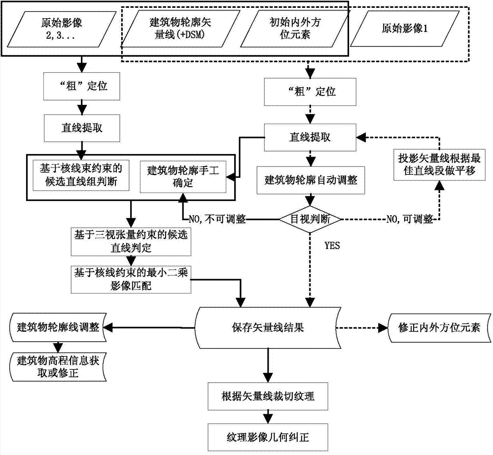
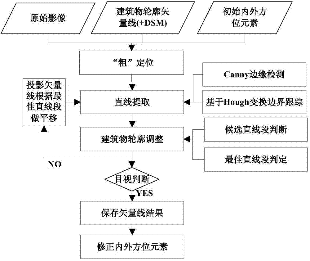
[0080] The first step is the automatic registration of building outlines and images

[0081] Such as figure 1 and 2 as shown,

[0082] 1) First perform "coarse" positioning. Use the collinear condition equation (Formula 1) to reverse-project the building outline vector line to the image to obtain a rough projection location, and set up a buffer zone around it to extract straight lines in this area.

[0083] x - x 0 = - f a 1 ( X - X s ) + b ...


PUM


Abstract

The invention discloses a building texture extraction method based on a UAV low-altitude aerial survey system. The method comprises the first step of automatic registration between a building contour line and an image, the second step of semi-automatic registration between the building contour line and the image on the basis of multi-view image linear matching, the third step of building facade texture extraction and the fourth step of building facade texture geometric correction. The building texture extraction method has the advantages that the method for automatic registration between the building contour line and the image is provided for solving the problem that registration is not achieved between a vector line and an image during building texture mapping; in consideration of the complexity that the mapping relation between a building space contour line and the image linear feature is built in multiple images, the image linear feature semi-automatic matching strategy based on multi-view geometric constraints is provided.

Description

technical field [0001] The invention relates to a method for extracting urban three-dimensional data textures, in particular to a method for extracting building textures based on a UAV low-altitude aerial survey system. Background technique [0002] Building texture extraction and processing methods and 3D modeling accuracy determine the production technology and application level of urban 3D models. The main problems in the current urban 3D modeling technology are as follows: [0003] ① 3D modeling production is characterized by low efficiency and high cost. From the analysis of fine 3D modeling technology, it is a difficult process to reconstruct the 3D geometric information and texture information of urban buildings. Even the semi-automatic reconstruction method is far from the actual application. It is basically in the manual or semi-automatic production of "embroidery on the computer". Level, the production volume of true 3D models is huge, which is the content with t...

Claims


Application Information

Patent Timeline
Patent Type & Authority Applications(China)
IPC IPC(8): G06T15/04G06T5/00
Inventor 解斐斐林宗坚苏国中郭金运王东东独知行陈传法刘智敏郭英孔巧丽郭斌
Owner SHANDONG UNIV OF SCI & TECH
Learn More