
Embedded type combined navigation system and method thereof

An integrated navigation system and integrated navigation technology, applied in the field of embedded integrated navigation systems, can solve the problems of affecting the navigation accuracy of the integrated navigation system, restricting the data communication quality of the integrated navigation system, reducing the navigation accuracy of the integrated system, etc., and achieve the convenience of realizing a tightly coupled system , fast computing and processing speed, efficient collection and processing

Inactive Publication Date: 2015-03-18
NANJING UNIV OF SCI & TECH
View PDF4 Cites 49 Cited by
  • Summary
  • Abstract
  • Description
  • Claims
  • Application Information

AI Technical Summary

Problems solved by technology

[0003] For the existing traditional distributed integrated navigation system, the SINS subsystem, the GNSS subsystem and the integrated navigation computer adopt the low-level communication method of the peripheral interface between the equipment, and the performance of the integrated navigation system is easily restricted by the quality of data communication between the subsystems. At the same time, there are problems such as large volume, scattered design, and low integration, which affect the use efficiency of the navigation system
[0004] In addition, for the integrated navigation system based on SINS and GNSS-assisted positioning, the SINS and GNSS subsystems still work independently in essence, and the Kalman filter is measurement-driven. The extremely short anomalies in the following subsystems will reduce the navigation accuracy of the combined system and make the system stability worse; at the same time, the system mathematical model and noise statistics are inaccurate, and noise mutations may lead to the convergence of the conventional Kalman filter. Variation, accuracy decline, and even filter divergence, also greatly affect the navigation accuracy of the combined system

Method used


Image

  • Embedded type combined navigation system and method thereof
  • Embedded type combined navigation system and method thereof
  • Embedded type combined navigation system and method thereof

Examples


Embodiment Construction

[0019] The present invention will be described in further detail below in conjunction with the accompanying drawings and specific embodiments.

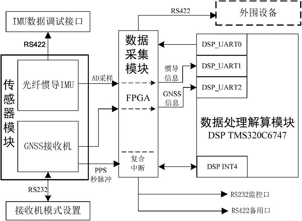
[0020] to combine figure 1 , the embedded integrated navigation system of the present invention has an overall size of 13cm×14cm×12cm and a weight of ≤3kg; the system includes a sensor module, a data acquisition module, a data processing module and a peripheral communication interface module; wherein the sensor module includes an optical fiber inertial IMU (Inertial Measurement Unit, Inertial Measurement Unit) and GNSS (Global Navigation Satellite System, Global Navigation Satellite System) receiver, data acquisition module is FPGA chip, data processing and solving module is DSP chip; sensor module and data processing and solving The module is connected through the high-speed bus of the data acquisition module. The ARM board of the optical fiber inertial navigation IMU is connected to the UART_1 of the DSP through the FPGA external ex...


PUM


Abstract

The invention discloses an embedded type combined navigation system and a method thereof. The system comprises a sensor module, a data acquisition module, a data processing and calculating module and a peripheral communication interface module, wherein the sensor module comprises an optical fiber inertial navigation IMU and GNSS receiver; the data acquisition module is an FPGA module; the data processing and calculating module is a DSP chip; the sensor module and the data processing and calculating module are connected by a high-speed bus of the data acquisition module. The combined navigation method comprises the following steps: transmitting measurement data of the optical fiber inertial navigation IMU and GNSS receiver to a DSP for data processing and calculating by a bus of an FPGA; establishing an SINS / GNSS combined navigation system mathematical model for multi-level fault-tolerant combined navigation; judging according to the state of a sub system, carrying out navigation decision-making matching; and transmitting the obtained real-time speed, position and posture information to peripheral equipment by the peripheral communication interface module. The system has the advantages of high integration, abundant interfaces, high precision and good fault tolerance.

Description

a technical field [0001] The invention belongs to the field of integrated navigation, in particular to an embedded integrated navigation system and its method. Two background technology [0002] As aviation technology has higher and higher requirements on the performance of navigation systems, integrated navigation systems have gradually replaced pure inertial navigation systems in engineering applications. Satellite / inertial integrated navigation combines the advantages of inertial navigation system and global satellite navigation system. It uses the latter to make auxiliary corrections to the former, suppresses the divergence of a single inertial system, and realizes high-precision integrated navigation under long-term voyages. It has been widely used It is used in the military field, such as the navigation system of guided weapons, and it is also widely used in the civilian field, such as the vehicle navigation system. [0003] For the existing traditional distributed in...

Claims


Application Information

Patent Timeline
IPC IPC(8): G01S19/49G01C21/16G01C21/20
CPCG01C21/005G01C21/20G01S19/49
Inventor 雷浩然陈帅车欢常耀伟王磊杰钟润伍金磊丁翠玲刘亚玲
Owner NANJING UNIV OF SCI & TECH
Learn More