Eureka AIR delivers breakthrough ideas for toughest innovation challenges, trusted by R&D personnel around the world.

Method and system for intelligently generating position description based on longitude and latitude

A technology of relative position description, longitude and latitude, which is applied to services based on location information, special data processing applications, instruments, etc. It can solve the problems of ambiguity of location, queuing, and the public's unclear house number, etc., and improve work efficiency. , the effect of reducing the waste of time

Inactive Publication Date: 2015-01-28
GAEA INFORMATION TECH CO LTD
View PDF3 Cites 8 Cited by
  • Summary
  • Abstract
  • Description
  • Claims
  • Application Information

AI Technical Summary

Problems solved by technology

For example, you can’t get a taxi when you go out, there is a queue for calling a taxi, and the taxi can’t arrive in time, etc. A series of problems
Second, the efficiency of receiving information by 110 callers
[0006] In the existing technology, the current specific location is mainly described in the following two ways: the current location is determined by finding the nearest point POI (for example: Ganjiang Xilu Shaxian snacks), but this technology cannot provide the public with a more intuitive location description, As a result, the provided location is unclear, or the public cannot tell the specific location of the location at all; in addition, the current location can be determined by providing the house number, but there are also some problems, because most of the public do not know the specific house number of each location, Thus creating a situation where the public is ignorant of the house numbers provided

Method used


Image

  • Method and system for intelligently generating position description based on longitude and latitude
  • Method and system for intelligently generating position description based on longitude and latitude
  • Method and system for intelligently generating position description based on longitude and latitude

Examples


Embodiment Construction

[0024] Hereinafter, the present invention will be described in detail with reference to the drawings and examples. It should be noted that, in the case of no conflict, the embodiments in the present application and the features in the embodiments can be combined with each other.

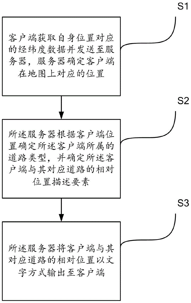
[0025] figure 1 It is a flowchart of a method for intelligently generating location descriptions based on latitude and longitude provided by a preferred embodiment of the present invention. Such as figure 1 As shown, the method for intelligently generating a location description based on longitude and latitude provided by a preferred embodiment of the present invention includes steps S1-S3.

[0026] Step S1: The client obtains the latitude and longitude data corresponding to its own location and sends it to the server, and the server determines the corresponding location of the client on the map.

[0027] Specifically, the client described in this embodiment has the function of identifying the lat...


PUM


Abstract

The invention provides a method and a system for intelligently generating position description based on longitude and latitude. The method comprises the following steps that (1) a client obtains longitude and latitude data corresponding to the position of the client and sends the data to a server, and the server determines the position corresponding to the client in a map; (2) the server determines the road type of the client according to the position of the client and determines a relative position description factor of the client and a corresponding road; (3) the server outputs the relative position of the client and the corresponding road to the client in a writing way.

Description

technical field [0001] The invention belongs to the field of mobile communication applications, in particular to a method and system for intelligently generating location descriptions based on latitude and longitude. Background technique [0002] With the continuous renewal and development of cities, a large number of new buildings, roads and other urbanization signs are constantly integrated into people's daily life. While greatly enriching urban life, it also complicates public life. Therefore, people urgently need to obtain accurate and comprehensive geographic information to meet daily needs, not just abstract data. In addition, due to the one-sidedness and inaccuracy of some geographic information, as well as the lack of timely follow-up in technology, the efficiency of social management departments is low and they cannot really meet social needs. [0003] Specifically, there are mainly three problems as follows. First, public travel. With the expansion of cities an...

Claims


Application Information

Patent Timeline
Patent Type & Authority Applications(China)
IPC IPC(8): G06F17/30H04W4/02
CPCG06F16/9537
Inventor 周为群林金炼王康
Owner GAEA INFORMATION TECH CO LTD
Why Eureka
Eureka Blog
Learn More