Novel imaging method in agile satellite maneuvering
A satellite and imaging technology, applied in special data processing applications, measuring devices, instruments, etc., can solve the problems that satellites cannot achieve pointing, cannot meet, and cannot meet the imaging pointing requirements during maneuvering
- Summary
- Abstract
- Description
- Claims
- Application Information
AI Technical Summary
Problems solved by technology
Method used
Image
Examples
Embodiment Construction
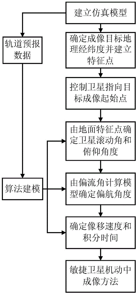
[0035] Such as figure 1 As shown, the present invention provides a method for imaging in agile satellite maneuvers, the steps are as follows:
[0036] (1) set up the model of satellite and on-star sensor in simulation tool, set up satellite attitude and on-star sensor parameter; Described on-star sensor adopts TDICCD; Wherein, TDICCD is linear array time delay integral CCD; Described simulation tool is Satellite Toolkit STK.
[0037] In this step, STK is used as a simulation tool. Open the STK software, create a new satellite, and input orbital parameters, including epoch time, semi-major axis, eccentricity, orbital inclination, perigee depression angle, ascending node accuracy, and mean anomaly angle. The HPOP disturbance model of the earth is selected as the derivation model of the satellite orbit, and EOPv1.1 is selected as the pointing parameter of the earth model. Create a new sensor on the satellite, and set the field of view of the sensor according to the field of vi...
PUM
 Abstract
Description
Claims
Application Information
 - R&D
- Intellectual Property
- Life Sciences
- Materials
- Tech Scout
- Unparalleled Data Quality
- Higher Quality Content
- 60% Fewer Hallucinations
Browse by: Latest US Patents, China's latest patents, Technical Efficacy Thesaurus, Application Domain, Technology Topic, Popular Technical Reports.
© 2025 PatSnap. All rights reserved.Legal|Privacy policy|Modern Slavery Act Transparency Statement|Sitemap|About US| Contact US: help@patsnap.com


