Landslide emergency monitoring system

A monitoring system and multi-channel acquisition technology, applied in transmission systems, measuring devices, climate change adaptation, etc., can solve problems such as long construction time, complicated installation and layout, and overall bulkiness, with low requirements, simple structure, and easy installation and layout Effect

Inactive Publication Date: 2014-07-23
CENT FOR HYDROGEOLOGY & ENVIRONMENTAL GEOLOGY CGS
View PDF8 Cites 3 Cited by
  • Summary
  • Abstract
  • Description
  • Claims
  • Application Information

AI Technical Summary

Problems solved by technology

[0003] The present invention provides a landslide emergency monitoring system to solve the problems of the existing geological disaster monitoring equipment, such as bulky overall, complex installation and layout, long construction time, high requirements for power supply and communication system, and single technical means for remote data transmission. system

Method used


Image

  • Landslide emergency monitoring system
  • Landslide emergency monitoring system
  • Landslide emergency monitoring system

Examples


Embodiment Construction

[0025] In order to clarify the characteristics and working principles of the present invention more clearly, the present invention will be described below in conjunction with the accompanying drawings and embodiments.

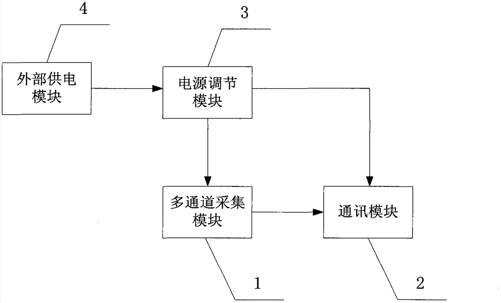
[0026] This specific embodiment provides a landslide emergency monitoring system, such as figure 1 shown, including:

[0027] The multi-channel acquisition module 1 is used to send the multi-channel input acquisition data to the communication module 2;

[0028] The communication module 2 is used to upload the collected data received through the GPRS network, CDMA network or Beidou satellite network;

[0029] The power adjustment module 3 is used to control the multi-channel acquisition module 1 and the communication module 2 to be supplied with power only during work by means of partitioned power supply;

[0030] The external power supply module 4 is used to provide power for the power regulation module 3 through a 220V AC power supply or a solar battery modu...


PUM


Abstract

The invention provides a landslide emergency monitoring system. The landslide emergency monitoring system comprises a multi-channel collection module (1), a communication module (2), a power supply regulating module (3) and an external power supply module (4); the multi-channel collection module (1) is used for sending collection data input through multiple channels to the communication module (2); the communication module (2) is used for uploading the received connection data through a GPRS (General Packet Radio Service) network, a CDMA (Code Division Multiple Access) network or a beidou satellite network; the power supply regulating module (3) is used for controlling a power supply to be supplied for the multi-channel collection module (1) and the communication module (2) only during work in a partitioning power supply mode; the external power supply module (4) is used for supplying a power supply for the power supply regulating module (3) through a 220 v alternating current power supply or a solar cell assembly. According to the landslide emergency monitoring system, the data collected through the multi-channel collection module are uploaded in three optional ways, the power can be supplied in a 220 v alternating current or solar energy mode, and accordingly the geological monitoring on the area which is multiple in geological disaster and poor in geological condition and communication condition is achieved, the structure is compact, installation and layout are easy, the requirements for the power supplies and communication devices are low, and accordingly the landslide emergency monitoring system is suitable for emergency monitoring work under the emergency geological disaster condition.

Description

technical field [0001] The invention relates to a landslide emergency monitoring complex instrument based on embedded electronic technology, network communication technology, computer software, sensor detection and field protection technology. Background technique [0002] For areas with high incidence of geological disasters, the monitoring of sudden geological disasters is a difficult point. At present, commonly used monitoring equipment generally has professional types that are relatively bulky, complex installation and layout, long construction time, high requirements for power supply and communication systems, and long-distance transmission. The shortcomings of single data technology means cannot meet the needs of emergency monitoring work. Contents of the invention [0003] The present invention provides a landslide emergency monitoring system to solve the problems of the existing geological disaster monitoring equipment, such as bulky overall, complex installation a...

Claims


Application Information

Patent Timeline
Patent Type & Authority Applications(China)
IPC IPC(8): G01D21/02H04L29/06H02J7/35
CPCY02A30/14
Inventor 殷跃平陈红旗曹修定吴悦杨凯董翰川潘书华
Owner CENT FOR HYDROGEOLOGY & ENVIRONMENTAL GEOLOGY CGS
Why Eureka
Try Eureka