Multiple-angle navigation satellite bistatic synthetic aperture radar (SAR)-based image fusion method

A synthetic aperture radar, navigation satellite technology, applied in image enhancement, image data processing, graphic image conversion and other directions, can solve problems such as high noise and discontinuous edge contours

Active Publication Date: 2014-06-18
BEIJING INSTITUTE OF TECHNOLOGYGY
View PDF1 Cites 8 Cited by
  • Summary
  • Abstract
  • Description
  • Claims
  • Application Information

AI Technical Summary

Problems solved by technology

Similarly, the image fused by the selected method retains almost all the features, but there will be discontinuous edge contours and too much noise
How to choose a suitable fusion algorithm based on the nature of the GNSS-BiSAR image itself, but there are no relevant literature and reports

Method used


Image

  • Multiple-angle navigation satellite bistatic synthetic aperture radar (SAR)-based image fusion method
  • Multiple-angle navigation satellite bistatic synthetic aperture radar (SAR)-based image fusion method
  • Multiple-angle navigation satellite bistatic synthetic aperture radar (SAR)-based image fusion method

Examples


Embodiment Construction

[0040] The present invention will be described in detail below with reference to the accompanying drawings and examples.

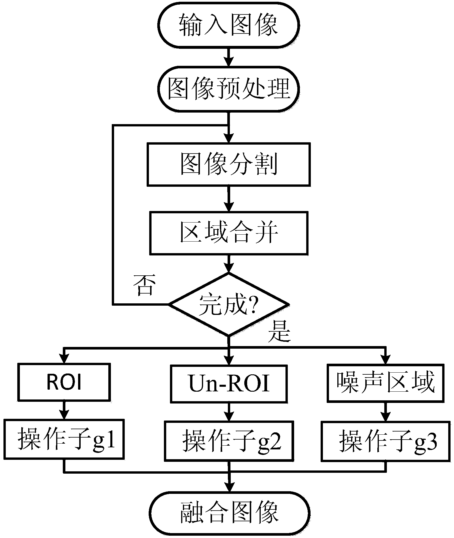
[0041] The present invention provides a bistatic synthetic aperture radar image fusion method based on multi-angle navigation satellites. Firstly, images illuminated by multiple different angles of the same target scene are obtained, and then based on the analysis of image features, the image areas are classified, and finally Different fusion algorithms are used in different regions to obtain fused images with high quality and strong interpretability. The flow chart of the present invention is as figure 1 As shown, the specific steps are as follows.

[0042] Step one, image preprocessing.

[0043] Obtain GNSS-BiSAR images illuminated by multiple different angles of the same target scene. For these images, due to the different positions of the navigation satellites, the intensity of the images will be different. For example, the image intensity value of l...


PUM


Abstract

The invention discloses a multiple-angle navigation satellite bistatic synthetic aperture radar (SAR)-based image fusion method. By applying the multiple-angle navigation satellite bistatic SAR-based image fusion method, fusion of multiple SAR images can be realized, and a better image is obtained. The method comprises the steps: firstly obtaining images from multiple-angle illuminating of the same target image; performing adaptive segmentation on image regions on the basis of image characteristic analysis, wherein an MRF segmentation method is improved according to the resolution ratio of the SAR images, and meanwhile a G0 model is used for describing a GNSS-BiSAR image; finally adopting different fusion algorithms on different areas to obtain a fusion image which is higher in quality and high in interpretability, the function of improving the image quality and interpretability is realized, the application potential of a navigation satellite bistatic SAR is expanded, and the effect is good.

Description

technical field [0001] The invention relates to the field of synthetic aperture radar technology and SAR image processing technology, in particular to a bistatic synthetic aperture radar image fusion method based on multi-angle navigation satellites. Background technique [0002] Synthetic Aperture Radar (SAR) is an all-weather, all-time high-resolution microwave remote sensing imaging radar that can be installed on aircraft, satellites, missiles and other flying platforms. Since its invention in the 1950s, it has been widely used in many fields, such as disaster control, vegetation analysis, microwave remote sensing and other fields. [0003] Bistatic SAR (BiSAR) is an emerging radar system. One of its advantages is that it can use the external radiation source signal as the irradiation source. There are many such external radiation source signals, such as TV, satellite, and existing monostatic radar transmitters. This kind of passive SAR does not need to use a separate t...

Claims


Application Information

Patent Timeline
Patent Type & Authority Applications(China)
IPC IPC(8): G06T5/50G06T3/40
Inventor 曾涛胡程敖东阳田卫明张天刘飞峰
Owner BEIJING INSTITUTE OF TECHNOLOGYGY
Why Eureka
Try Eureka