Mountain area remote sensing image landform correction method by use of slope rating C model

A technology of terrain correction and slope grade, which is applied in image enhancement, image data processing, instruments, etc., to achieve the effect of simple terrain correction, improved work efficiency, and convenient operation

Inactive Publication Date: 2014-05-07
BEIJING FORESTRY UNIVERSITY
View PDF2 Cites 3 Cited by
  • Summary
  • Abstract
  • Description
  • Claims
  • Application Information

AI Technical Summary

Problems solved by technology

[0007] In order to overcome the many troubles caused by the existing terrain correction methods in the terrain correction process of remote sensing images in mountainous areas, and to improve the correction accuracy and work efficiency, the purpose of the present invention is to provide a terrain correction of grade C for remote sensing images in mountainous areas and its use method, to realize The high-precision terrain correction of remote sensing images under the condition that the terrain correction accuracy of remote sensing images is not high, overcomes the shortcomings of existing technologies

Method used


Image

  • Mountain area remote sensing image landform correction method by use of slope rating C model

Examples


specific Embodiment approach

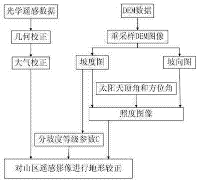
[0018] The sub-slope level C model is composed of the sub-slope level coefficient C and the cosine correction model to perform terrain correction on remote sensing images in mountainous areas, where the sub-slope level coefficient C is 1-5, 5-10, 10-15, 15-20, 20-25 , 25-30, 30-35, 35-40, 40-45, 45- the maximum slope, a grade every 5 degrees (except 0-1 degree), the slope grade coefficient C is calculated with the cosine correction module respectively, and the points Slope grade coefficient C calculates the relationship between the coefficient C and the cosine correction model in sections. The sub-slope grade coefficient C and the cosine correction model compose the sub-slope grade C model terrain correction. The specific implementation is as follows:

[0019] When terrain correction is performed on remote sensing images in mountainous areas with complex terrain conditions, if there are steep slopes or gentle slopes in the remote sensing image processing area that cannot be f...


PUM


Abstract

The invention discloses a mountain area remote sensing image landform correction method by use of a slope rating C model. Cosine landform correction and a slope rating coefficient C form remote sensing image slope rating C landform correction. According to the slope rating coefficient C, every 5 degrees define a rating, and 0-1 degrees are excluded. The coefficient of each slop rating is added to the cosine landform correction. By use of slope rating C landform correction formed by the cosine landform correction and the slope rating coefficient C in the remote sensing image slope rating C landform correction, the cosine landform correction is selected to be combined with the slope rating coefficient C so that remote sensing image landform correction can carry out landform correction on a mountain area remote sensing image, the disadvantage is overcome that only a coefficient C is applied to a positive amplitude remote sensing image, the slope rating C model landform correction is simple and is convenient to operate, and the precision of mountain area remote sensing image landform correction is improved.

Description

technical field [0001] The invention relates to a method for performing terrain correction on remote sensing images in mountainous areas in remote sensing image processing, in particular to a method for performing terrain correction on remote sensing images in mountainous areas by a gradient grade C model. technical background [0002] In the traditional mountainous remote sensing image terrain correction, over-correction has always been a difficult problem to solve, usually using COS model, SCS model, C model, SCS+C model, CIVCO model, Minaert model, statistical empirical model, applied physical model, Statistical empirical models, semi-physical and semi-empirical models, all of the above methods have their shortcomings: [0003] ① In the terrain correction of remote sensing images, the COS model and SCS model, when applying physical models, are limited by factors such as terrain, slope, and stand density, making it difficult to measure the horizontal distance, and the calc...

Claims


Application Information

Patent Timeline
Patent Type & Authority Applications(China)
IPC IPC(8): G06T5/00
Inventor 张晓丽李宏志王月婷张凝王书涵董素静
Owner BEIJING FORESTRY UNIVERSITY
Why Eureka
Try Eureka