A high-precision registration method for terrestrial lidar and close-range photogrammetry data

A technology of ground laser radar and close-range photography, which is applied in the direction of measuring devices, image data processing, radio wave measurement systems, etc., can solve the problems of incompatible photogrammetry data processing methods, inability to register image point clouds, and low degree of automation. Achieve the effects of improving work efficiency, improving accuracy and efficiency, and narrowing the matching range

Active Publication Date: 2016-03-02
BEIJING UNIV OF CIVIL ENG & ARCHITECTURE
View PDF5 Cites 1 Cited by
  • Summary
  • Abstract
  • Description
  • Claims
  • Application Information

AI Technical Summary

Problems solved by technology

[0004] Some of the above research results have a low degree of automation, and some generate image point cloud models under certain known conditions, and then perform registration between the image point cloud and the lidar scanning point cloud
At present, close-range photogrammetry images are acquired manually with non-measuring cameras, and there are no image control points on the scanned object. If there are no control points, the laser scanning point cloud must be used as the overall control. This situation does not conform to the original The processing method of photogrammetry data cannot generate accurate image point cloud for registration, which is also the main problem to be solved by the present invention

Method used


Image

  • A high-precision registration method for terrestrial lidar and close-range photogrammetry data
  • A high-precision registration method for terrestrial lidar and close-range photogrammetry data
  • A high-precision registration method for terrestrial lidar and close-range photogrammetry data

Examples


Embodiment Construction

[0049] The present invention will be further described in detail below in conjunction with the accompanying drawings, so that those skilled in the art can implement it with reference to the description.

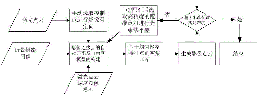
[0050] Terrestrial lidar obtains the three-dimensional information of the scanned object by scanning, and performs geometric reconstruction. In order to complete the texture reconstruction, the object needs to be photographed, and the three-dimensional texture reconstruction is carried out through the registration of the two kinds of data. Due to the difference in resolution between a single image and a point cloud, there will be a texture seam between two adjacent images during texture reconstruction. Therefore, this invention studies the laser radar scanning point cloud and close-range photogrammetry images. , using the relative orientation of high overlapping images to eliminate texture seams between adjacent images, and using high-precision registration between image poin...


PUM


Abstract

The invention discloses a high-precision registration method for a ground laser radar and a close-range photography measurement data. The method comprises the following steps: obtaining multiple close-range photographic images of a scanned object and obtaining a three-dimensional point cloud of the scanned object by a ground laser radar; carrying out SIFT feature extraction and matching based on the pyramid image of the multiple close-range photographic images and generating a free network model of the scanned object according to the matched result; carrying out bundle adjustment on the free network model by using feature points of the three-dimensional point cloud and the image as control points so as to realize coarse positioning on the multiple close-range photographic images; on the basis of a three-dimensional point cloud depth image model generated by point cloud sampling based on the uniform grid of the reference surface of the three-dimensional point cloud, completing prediction and dense matching of corresponding image points of two adjacent close-range photographic images among the multiple close-range photographic images and generating an image point cloud of the scanned object; and carrying out ICP loop iteration registration on the obtained three-dimensional point cloud and image point cloud of the scanned object to realize high-precision registration.

Description

technical field [0001] The invention belongs to the field of terrestrial laser radar and photogrammetry data fusion. Since ground lidar data requires texture data, the two need to be registered before data fusion can be performed. The invention mainly studies a new method for high-precision registration of ground laser radar point cloud and photogrammetry image, so as to carry out subsequent fusion and reconstruction of the two kinds of data. Background technique [0002] Terrestrial lidar can quickly, large-area, and high-precision acquire the 3D point cloud model of the scanned object, so as to perform 3D geometric reconstruction, but it lacks texture information, and 3D texture reconstruction can only be performed through registration with texture images. Currently, there are two ways to obtain textures: one is a single texture image, and the other is a photogrammetry image. The registration of a single texture image and point cloud is two-dimensional and three-dimensio...

Claims


Application Information

Patent Timeline
Patent Type & Authority Patents(China)
IPC IPC(8): G06T7/00G01S17/02G01C11/04
CPCG01C11/04G01S17/86
Inventor 王晏民胡春梅
Owner BEIJING UNIV OF CIVIL ENG & ARCHITECTURE
Why Eureka
Try Eureka