Intersected radiometric calibration method for satellite-borne multispectral infrared sensor

A technology of infrared sensor and radiation calibration, applied in the direction of utilizing re-radiation, re-radiation of electromagnetic waves, instruments, etc., to achieve the effect of improving economic benefits, broadening the scope, and improving execution efficiency

Inactive Publication Date: 2014-04-16
INST OF GEOGRAPHICAL SCI & NATURAL RESOURCE RES CAS +1
View PDF3 Cites 14 Cited by
  • Summary
  • Abstract
  • Description
  • Claims
  • Application Information

AI Technical Summary

Problems solved by technology

[0054] The present invention is an invention proposed in view of solving the above-mentioned technical problems in the existing GSICS cross-radiation calibration

Method used


Image

  • Intersected radiometric calibration method for satellite-borne multispectral infrared sensor
  • Intersected radiometric calibration method for satellite-borne multispectral infrared sensor
  • Intersected radiometric calibration method for satellite-borne multispectral infrared sensor

Examples


Embodiment Construction

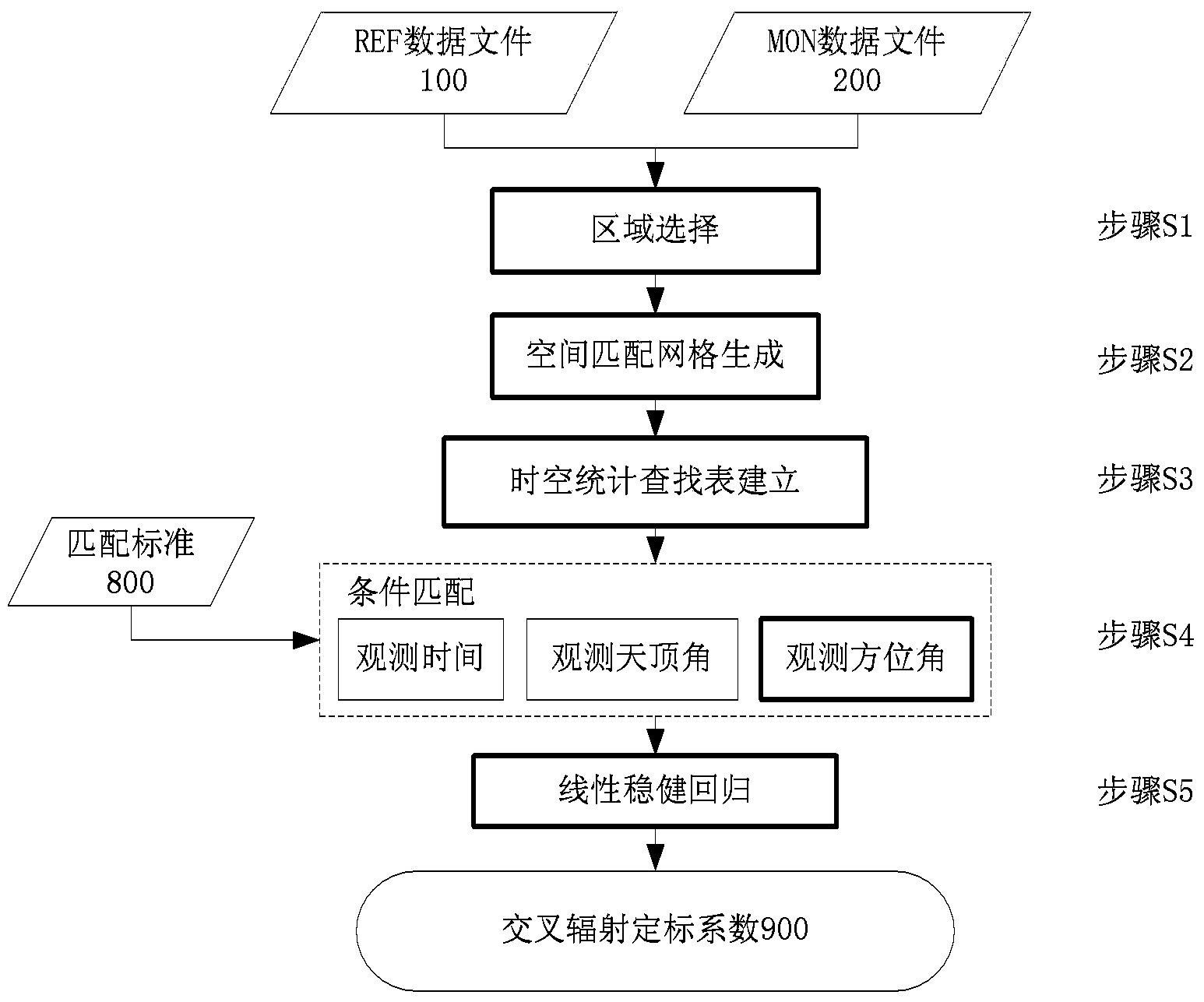
[0086] In order to make the object, technical solution and advantages of the present invention clearer, the present invention will be described in further detail below in conjunction with specific embodiments and with reference to the accompanying drawings. The present invention proposes a cross-radiation calibration method for space-borne multi-spectral infrared sensors, which generates a space-matching grid by aggregating pixels, establishes a spatio-temporal statistical lookup table, and introduces the methods of observation azimuth difference inspection and linear robust regression, which overcomes the existing It has the above-mentioned technical problems of the GSICS cross-radiometric calibration method, and is suitable for cross-radiometric calibration of infrared channels of geostationary and polar-orbiting satellites at the same time.

[0087] In the cross-radiation calibration process of the spaceborne multispectral infrared sensor of the present invention, REF can be...


PUM


Abstract

An intersected radiometric calibration method for a satellite-borne multispectral infrared sensor comprises steps of S1, selecting out the optimal intersected radiometric calibration area of the satellite sensor according to REF data files and MON data files; S2, evenly dividing the optimal intersected radiometric calibration area into space matching grids at intervals with the same longitude and latitude; S3, establishing a space-time statistical lookup table, wherein the space-time statistical lookup table is formed by a space index table, a time index table and a file statistical table, and space matching grid aggregation information is written in the file statistical table; S4, selecting out radiance matching data meeting matching conditions in the space matching grid aggregation information according to the space matching grid aggregation information; S5, establishing statistical regression relationships among all the radiance matching data by means of a linear robust regression method to estimate intersected radiometric calibration coefficients.

Description

technical field [0001] The invention relates to the technical field of space and earth observation, in particular to a cross-radiation calibration method for a spaceborne multispectral infrared sensor. Background technique [0002] The field of space and earth observation technology is a cutting-edge comprehensive technology field involving many disciplines and application fields such as aerospace, optoelectronics, physics, computer, and information science. It mainly uses ground remote sensing vehicles, balloons, airships, aircraft (aviation, aerospace), Various platforms such as satellites realize three-dimensional, real-time observation and dynamic monitoring of the earth's land, atmosphere, and oceans, and provide macroscopic, accurate, comprehensive, continuous and diverse information and data on the earth's surface, thus changing the way humans obtain earth system data and understand it. Cognitive ways of the earth system. [0003] In the early 1980s, with the compreh...

Claims


Application Information

Patent Timeline
IPC IPC(8): G01S7/497G01J3/28
CPCG01J3/28G01S7/497G01S17/95
Inventor 吴骅李召良唐伯惠唐荣林倪丽
Owner INST OF GEOGRAPHICAL SCI & NATURAL RESOURCE RES CAS
Why Eureka
Try Eureka