
Urban illegal building identification system and method based on three-dimensional live-action data

A technology of illegal building and identification system, applied in the field of urban illegal building identification system, can solve the influence of camera angle, seasonal factors and human factors, can not well reflect the illegal situation of urban low-rise buildings, cannot identify urban environmental data, etc. question

Inactive Publication Date: 2014-02-26
SHENZHEN INST OF ADVANCED TECH CHINESE ACAD OF SCI
View PDF4 Cites 21 Cited by
  • Summary
  • Abstract
  • Description
  • Claims
  • Application Information

AI Technical Summary

Problems solved by technology

However, this patent is only applicable to specific areas or long-term tracking detection and early warning of specific buildings, and cannot identify large-scale urban environmental data
[0004] Publicly published papers "Recognition of Urban Illegal Buildings Based on Aerial Imagery" and "Monitoring Illegal Buildings in Beijing Using my country's High-Resolution Satellite Imagery" etc., use aerial images as data sources, due to their accuracy, resolution and shooting angles, etc. Aerial images cannot well reflect the violations of urban low-rise buildings, and these areas are precisely the areas where urban violations occur frequently
Moreover, the existing image-based (including aerial images) detection and recognition methods for illegal buildings will be affected by many factors, such as lighting conditions, shooting angles, seasonal factors and human factors, which will greatly increase the difficulty of detection and Reduce the recognition rate

Method used


Image

  • Urban illegal building identification system and method based on three-dimensional live-action data
  • Urban illegal building identification system and method based on three-dimensional live-action data

Examples


Embodiment Construction

[0029] The present invention will be further described in detail below in conjunction with the accompanying drawings and specific embodiments.

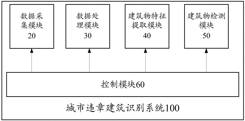
[0030] Please refer to figure 1 , the present invention discloses an urban illegal building recognition system 100 based on three-dimensional real scene data, including a data acquisition module 20, a data processing module 30, a building feature extraction module 40, a building detection module 50 and a control module for controlling the above modules 60.

[0031] The data acquisition module 20 collects the panoramic image data of the urban road environment and the three-dimensional point cloud data of surrounding buildings through the data acquisition vehicle. The data acquisition vehicle has laser radar scanning equipment, road panoramic image acquisition equipment and positioning equipment, the road panoramic image acquisition equipment is used to obtain panoramic image data, the laser radar scanning device is used to obtain thre...


PUM


Abstract

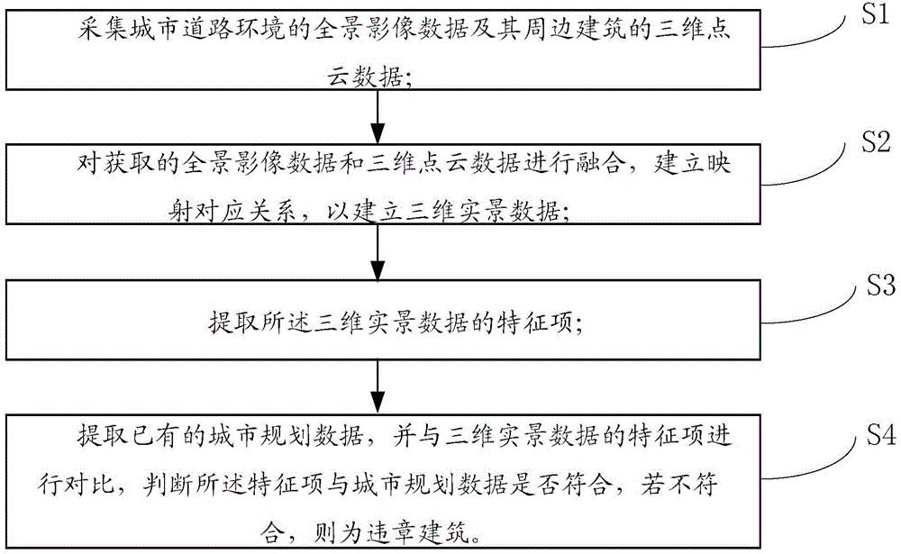
The invention provides an urban illegal building identification system and method based on three-dimensional live-action data. The method comprises the following steps: step 1, panoramic image data of an urban road environment and three-dimensional point cloud data of a surrounding building are collected; step 2, the obtained panoramic image data and the obtained three-dimensional point cloud data are merged, and a mapping corresponding relation is established to form the three-dimensional live-action data; step 3, feature items of the three-dimensional live-action data are extracted; step 4, existing urban planning data are extracted and contrasted with the feature items of the three-dimensional live-action data, whether the feature items conform to the urban planning data is judged, and the building is an illegal building if the feature items do not conform to the urban planning data. By means of the novel method for identifying urban illegal buildings based on the three-dimensional live-action data, the influence of related influencing factors can be reduced to the minimum, and therefore the identification rate and robustness of the illegal buildings can be increased.

Description

technical field [0001] The invention relates to the field of electronic information, in particular to a system and method for identifying urban illegal buildings based on three-dimensional real scene data. Background technique [0002] Cities are the political, economic and cultural centers of various regions and play an important role in the process of national economic and social development. With the development of social economy and the drive of various interests, all kinds of illegal construction behaviors emerge in an endless stream, seriously restricting the development of urban modernization and the construction of a harmonious society. Illegal buildings are very harmful to urban construction and development, and have always been a thorny problem that plagues urban development. Therefore, it is of great significance to find illegal buildings as early as possible and implement demolition monitoring for them. [0003] Chinese patent CN201210541206.6 discloses a method...

Claims


Application Information

Patent Timeline
IPC IPC(8): G06K9/46G06Q10/06
Inventor 黄惠龙品辛石璕张小星陈宝权
Owner SHENZHEN INST OF ADVANCED TECH CHINESE ACAD OF SCI
Learn More