
Submarine topography change detection and analysis method based on mesh reconstruction

A technology of change detection and analysis methods, applied in the fields of seabed monitoring, computer graphics and seabed science, and marine surveying and mapping, it can solve problems such as the inability of quantitative analysis of seabed topography and landforms, and achieve the effect of improving comprehensive utilization efficiency.

Active Publication Date: 2013-11-13
SECOND INST OF OCEANOGRAPHY MNR
View PDF7 Cites 18 Cited by
  • Summary
  • Abstract
  • Description
  • Claims
  • Application Information

AI Technical Summary

Problems solved by technology

[0005] Aiming at the problem that the seabed topography and topography in the near-shore estuary and other highly variable areas cannot be quantitatively analyzed, the present invention proposes a detection and analysis method for seabed topography and topography based on grid reconstruction, by digitizing historical topography from different periods and sources And standardized processing, and then carry out fidelity reconstruction of DDTM on the seabed, perform difference calculation and analysis on DDTM in different periods, and establish a complete technical process and method

Method used


Image

  • Submarine topography change detection and analysis method based on mesh reconstruction
  • Submarine topography change detection and analysis method based on mesh reconstruction
  • Submarine topography change detection and analysis method based on mesh reconstruction

Examples


Embodiment 1

[0039] The detection and analysis method of offshore seabed topography and landform change based on grid reconstruction is established according to the following steps:

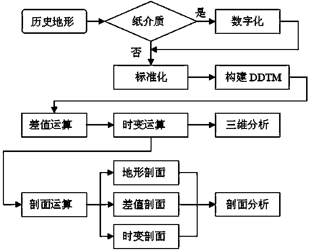
[0040] The complete working method flow is as follows figure 1 shown.

[0041] Step 1: Digital normalization of historical seabed topography

[0042] (1) Digitized historical paper topographic maps: If the existing topographic maps (such as nautical charts) are paper topographic maps, they can be scanned into electronic topographic maps by using a scanner first, and then use geographic information software (such as: ArcGIS or MapInfo etc.) to digitize the electronic topographic map as a vector topographic map. Digitize the seabed topographic maps of n periods to form n electronic terrain raw data sets Raw={raw i} i=1,n .

[0043] If the existing topographic map is electronic, go directly to step 1(2).

[0044] (2) Standardized historical topographic maps: check whether the basic parameters of seabed topog...


PUM


Abstract

The invention discloses a submarine topography change detection and analysis method based on mesh reconstruction. By adopting the method, the digitization and the standardization of historical terrains with a plurality of sources at different stages, and the reconstruction of a marine multi-dimensional space-time mesh are achieved, so that the quantitative analysis of the submarine topography change is achieved; detailed technical processes and methods are provided; data with a plurality of sources can be effectively utilized in the marine surveying and mapping process; the problems of efficient utilization and uniform standard contrast of the historical terrains in high terrain change areas of coastal estuaries and the like are overcome; the comprehensive utilization efficiency of the historical data quality and the data with the plurality of sources is improved; the submarine topography change detection and analysis method has an important practical application value in marine monitoring, marine surveying and mapping, research of computer graphics and marine science.

Description

technical field [0001] The invention relates to technical fields such as seabed monitoring, ocean surveying and mapping, computer graphics and seabed science. Background technique [0002] Seabed terrain change monitoring support is the basis for ocean forecasting, engineering design, resource development, ocean management, sea area demarcation, national defense security, and seabed scientific research. The area of ​​China's offshore waters shallower than 60 meters exceeds more than 800,000 square kilometers, of which the area of ​​waterways, harbors, estuaries, underwater deltas, and offshore major engineering implementation areas closely related to human activities reaches 400,000 square kilometers. Affected by natural factors, such as: sediment movement, hydrodynamics (runoff, tidal currents and ocean currents), weather processes (typhoons, floods) and emergencies (earthquakes, tsunamis), etc., as well as human activities (such as: reclamation, reclamation, engineering c...

Claims


Application Information

Patent Timeline
IPC IPC(8): G01C13/00
Inventor 吴自银姚才华尚继宏李守军赵荻能周洁琼罗孝文金肖兵
Owner SECOND INST OF OCEANOGRAPHY MNR
Learn More