
Organization and management method of map tile caching

A map tile and organizational management technology, applied in the field of tile cache organization and management, can solve the problem of not supporting tile incremental insertion and update of single tile data, reducing tile retrieval and reading efficiency, unfavorable tile Quick query and retrieval of tablets and other issues, to achieve efficient query retrieval and data reading, enhance operability and practicability, and improve practicability and scalability

Inactive Publication Date: 2013-09-04
INST OF REMOTE SENSING & DIGITAL EARTH CHINESE ACADEMY OF SCI
View PDF3 Cites 44 Cited by
  • Summary
  • Abstract
  • Description
  • Claims
  • Application Information

AI Technical Summary

Problems solved by technology

Essentially, both the weak relational table Bigtable and the relational database SQLite3 ignore the inherent spatial relationship between map tiles, which is not conducive to the rapid query and retrieval of tiles; although the multi-level folder retains the relationship between tiles Spatial relationship, but geometrically increased map tiles will drastically reduce the retrieval and reading efficiency of tiles; MPT files do not support incremental insertion of tiles and update of single tile data, which greatly reduces Operability of map caches

Method used


Image

  • Organization and management method of map tile caching
  • Organization and management method of map tile caching
  • Organization and management method of map tile caching

Examples


Embodiment Construction

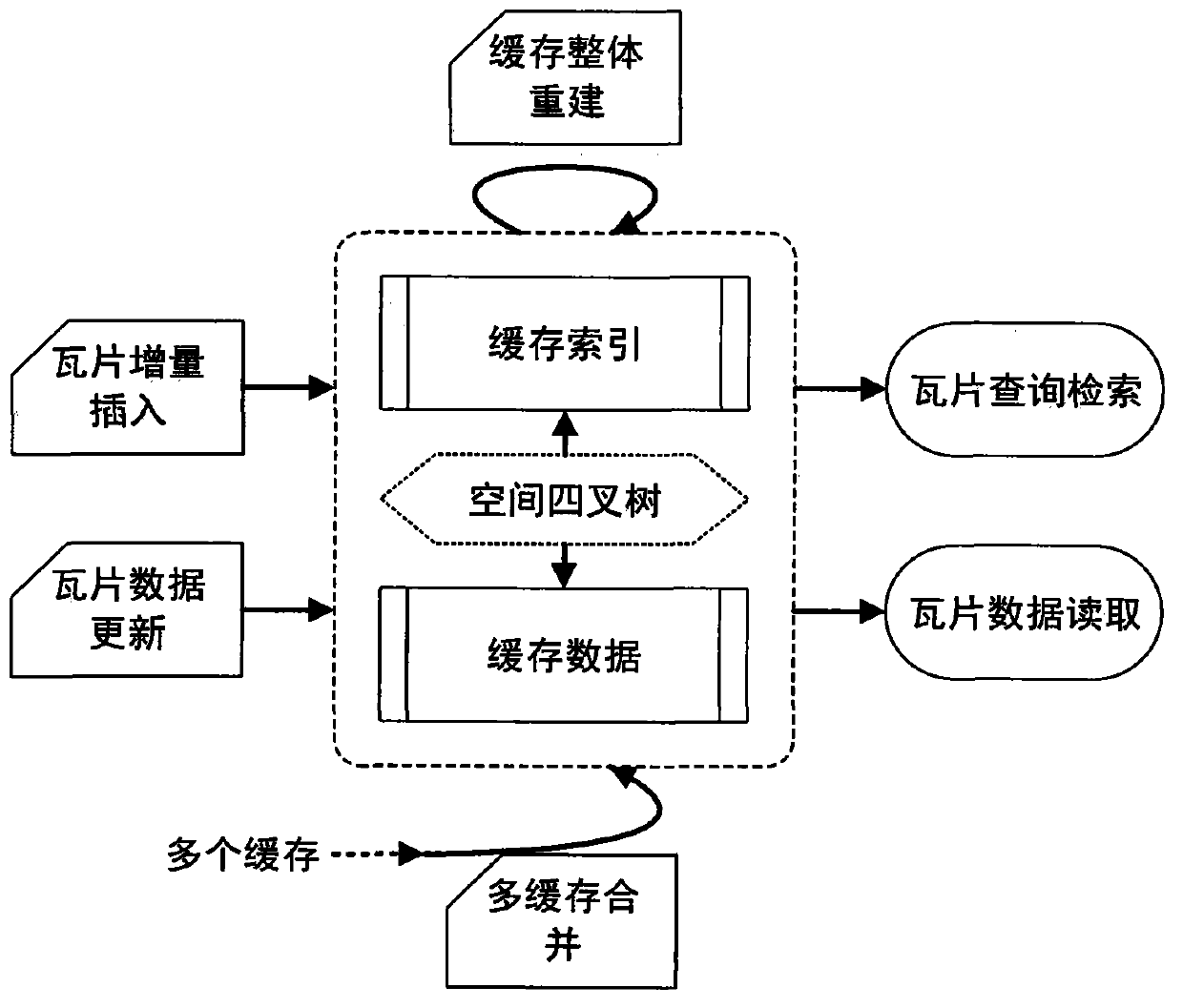
[0026] figure 1 It is a schematic diagram of map tile cache organization and management. The tile cache is composed of a separate cache index part and a cache data part, and the map tiles are spatially organized by quadtree technology; the tile cache organizational structure can quickly realize the query and retrieval of map tiles and tile The reading of data realizes the incremental insertion of map tiles and the update of single map tile data at the same time; and on this basis, the overall rebuilding of tile caches and the merging of multi-tile caches are realized.

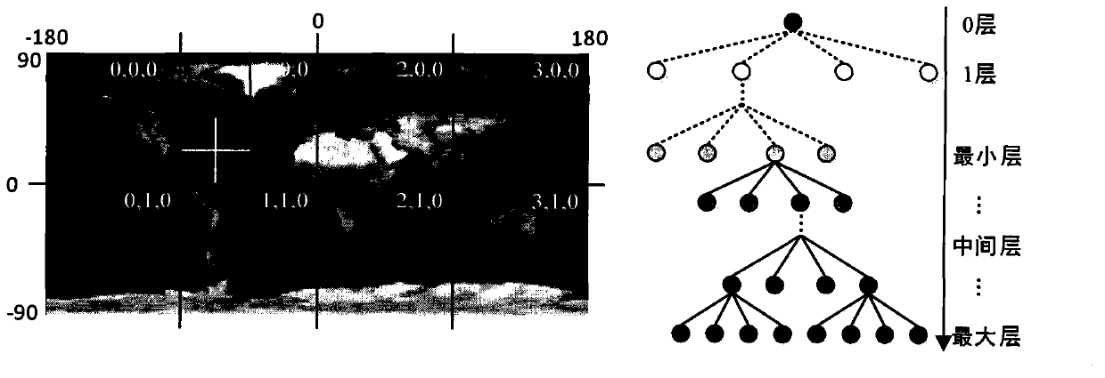
[0027] figure 2 It is a schematic diagram of the spatial quadtree index of map tiles. In the picture on the left, the map is divided into multiple layers using latitude and longitude (longitude [-180, 180] degrees, latitude [90, -90] degrees) grid, forming four columns in the longitude direction (longitude) and latitude in the bottom layer (0 layer). There are 2 rows in the direction (latitude direction), ...


PUM


Abstract

The invention provides a method of achieving high-efficiency organization and convenient management of map tile caching. The method greatly improves inquiring searching and data reading efficiency of the tile caching, and achieves incremental quantity insertion of map tiles, data updating of the tiles, overall reconstruction of the caching, combination of a lot of caching and other tile caching management functions. According to the method, on the basis that space quad-tree organization multi-layer map tiles are utilized, index files and data files of the caching are built respectively by means of separation of the index portion and the data portion of the tile caching. Inquiring searching of the map tiles are accelerated by means of the fact that internal storage maps the caching index files and a quad-tree access path is built. Incremental quantity insertion of the map tiles, data updating of the tiles, overall reconstruction of the caching and combination of the caching are achieved on the basis of separation storage of indexes and data. The method can be used for building a tile caching system of map service, the corresponding achieving method can be compatible with multiple map dividing methods, and high-efficiency organization and convenient management of map tile caching are achieved.

Description

technical field [0001] The present invention relates to a method for organizing and managing tile caches in web map services; in particular, it relates to spatial organization of map tiles, fast query retrieval and reading of map tiles, incremental insertion of tile caches, and update of single tile data , overall rebuilding of map tile caches and merging among multiple caches; the invention is applicable to the organization and management of tile caches of server and client in map services. Background technique [0002] Map caching is an effective way to improve the performance of map services. Currently popular web map services, such as Google Maps, Google Earth, World wind, Microsoft's Bing Maps, Skyline's TerraGate, etc., have relatively high requirements for browsing speed and concurrency, and all use map caching to meet the needs of fast access to maps . The so-called map caching technology is to cut the pre-generated map into map slices (map tiles) of certain specif...

Claims


Application Information

Patent Timeline
Patent Type & Authority Applications(China)
IPC IPC(8): G06F17/30
Inventor 周亚男骆剑承胡晓东沈占锋郜丽静
Owner INST OF REMOTE SENSING & DIGITAL EARTH CHINESE ACADEMY OF SCI
Learn More