Method and device for determining seal level elevation by extracting GPS (Global Position System) signal gravity frequency shift

A GPS signal, frequency shift technology, applied in measurement devices, satellite radio beacon positioning systems, altitude/level measurement and other directions, can solve problems such as difficulty in leveling measurement

Active Publication Date: 2014-05-14
WUHAN UNIV
View PDF4 Cites 0 Cited by
  • Summary
  • Abstract
  • Description
  • Claims
  • Application Information

AI Technical Summary

Problems solved by technology

[0007] Another purpose of the present invention is to solve the technical problems existing in the prior art that it is difficult to implement leveling between two points with very large elevation differences in mountainous areas or short distances; A method and device for determining altitude by extracting gravity frequency shift of GPS signals for measuring altitude difference between two points

Method used


Image

  • Method and device for determining seal level elevation by extracting GPS (Global Position System) signal gravity frequency shift
  • Method and device for determining seal level elevation by extracting GPS (Global Position System) signal gravity frequency shift
  • Method and device for determining seal level elevation by extracting GPS (Global Position System) signal gravity frequency shift

Examples


Embodiment

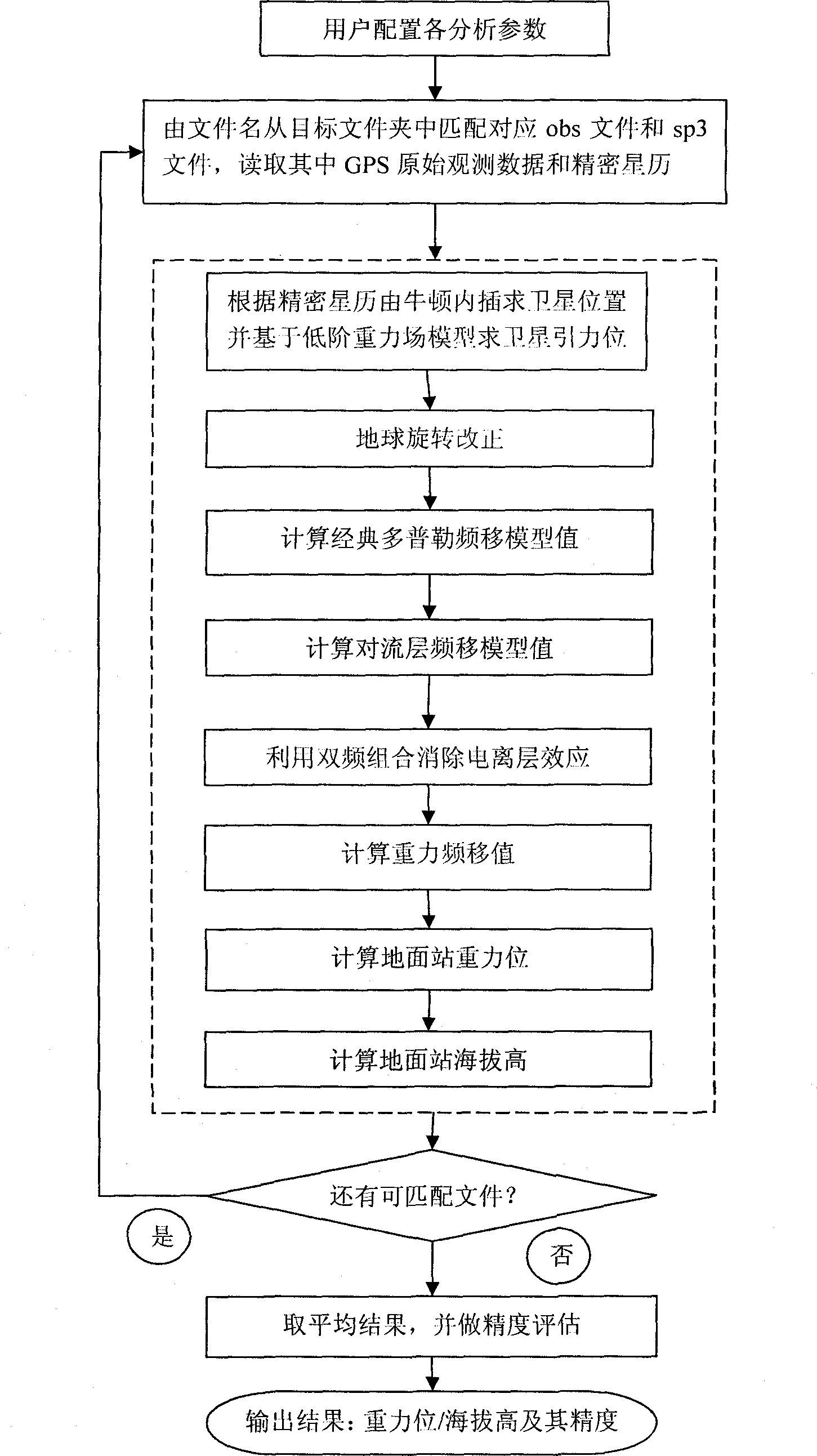
[0069] A method for determining altitude by extracting gravity frequency shift of GPS signal, is characterized in that, comprises the following steps:

[0070] Step 1, the parameter configuration module configures various analysis parameters according to user needs, including setting low-order gravity potential model, classical Doppler frequency shift model, tropospheric model, Newton interpolation order and differential time interval;

[0071] Step 2, read in the GPS observation file from the GPS file by the GPS parameter reading module, including the obs file and the precise ephemeris sp3 file, and obtain the total frequency shift;

[0072] Step 3, the satellite positioning module determines the satellite position through Newton interpolation according to the precise ephemeris, the Newton interpolation selects the interpolation order in step 1, and calculates the satellite gravitational position based on the low-order gravity field model;

[0073] Step 4, implementing earth ...


PUM


Abstract

The invention discloses a method and device for determining seal level elevation, in particular relates to a method and device for determining seal level elevation by extracting GPS (Global Position System) signal gravity frequency shift. In the method, gravity frequency shift can be extracted based on GPS observation data (obs documents and sp3 documents) provided by an IGS (International GNSS (Global Navigation Satellite System) Service), and the gravity potential and the elevation of a single station are further determined based on gravity frequency shift signals. In addition, by means of a gravity field model, a theoretical value of the gravity frequency shift can be calculated and the effectiveness of the extracted gravity frequency shift signals can be verified. Accordingly, the invention has the following advantages: 1, because leveling measurement between two points with longer distance can be carried out without uninterrupted transmission by a plurality (or multiple) intermediate instrument stations, manpower and material resources are saved, a measurement period is short and the measurement is precise; 2, the measurement on a seal level elevation difference can be carried out between two points in a mountainous area or a place with higher near-distance elevation difference; and 3, a globally unified elevation datum can be realized.

Description

technical field [0001] The invention relates to a method and a device for determining altitude, in particular to a method and a device for determining altitude by extracting gravity frequency shift of GPS signals. Background technique [0002] It is an important task in the field of earth science to accurately determine the altitude of ground points (referred to as altitude). Altitude is the distance along the gravitational plumb line to the geoid. By common definition, the geoid is the gravitational equipotential surface closest to the mean sea surface (Listing, 1872, Grafarend, 199obs). Accurately providing the altitude of the ground point has important scientific value and application value for the study of global climate circulation problems corresponding to terrain changes, various engineering constructions, and geospatial information services. [0003] Using the traditional method to determine the altitude needs to use the method of gravity measurement combined with ...

Claims


Application Information

Patent Timeline
Patent Type & Authority Patents(China)
IPC IPC(8): G01C5/00G01S19/42
Inventor 申文斌田伟万俊堃冯晨侯凯杨茜秦晓峰
Owner WUHAN UNIV
Why Eureka
Try Eureka