


Quick Research
Generate reliable direction feasibility study reports for your R&D in just a few steps.

Technical Q&A
Discover and master advanced knowledge NOW. Basics, ideas, possibilities, all at once.

Find Solutions
As an expert in R&D theories, this can generate solutions to your technical problems instantly.

Evaluate Feasibility
Analyze your overall solution with one click, know your potential R&D risks in advance.

Monitor Landscape
Get weekly tech updates, stay abreast of the latest tech innovations and key insights.
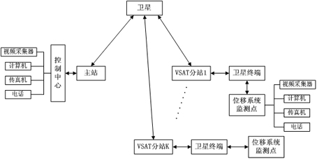
System for real-time monitoring safety of large-sized building based on satellite communication
A real-time monitoring system and satellite communication technology, applied in satellite radio beacon positioning system, signal transmission system, radio wave measurement system, etc., can solve the problems that monitoring equipment cannot be monitored, resources cannot be shared, etc.
- Summary
- Abstract
- Description
- Claims
- Application Information
AI Technical Summary
Problems solved by technology
Method used
Image


Examples
Embodiment Construction
[0010] Firstly, the solar power supply device is started to continuously provide power for the equipment. The control center uses the satellite GPS positioning and timing system to accurately locate all the transceiver subsystems of each monitoring point in the country and connect them to the GPS satellite clock source. The satellite link is used to signal the whole system to start working. When the whole system starts to work, the displacement sensor of each monitoring point monitors the horizontal and vertical three-dimensional space of the monitoring point. When there is a vibration, the sensor at the monitoring point will generate a displacement and alarm at the same time, and the information will be transmitted back to the control center through the satellite transmission system installed at the monitoring point.
[0011] Seismic waves spread outward in an arc, and those close to the center of the arc first generate displacement and alarms. The control center notifies oth...
PUM
 Abstract
Description
Claims
Application Information
 - R&D Engineer
- R&D Manager
- IP Professional
- Industry Leading Data Capabilities
- Powerful AI technology
- Patent DNA Extraction
Browse by: Latest US Patents, China's latest patents, Technical Efficacy Thesaurus, Application Domain, Technology Topic, Popular Technical Reports.
© 2024 PatSnap. All rights reserved.Legal|Privacy policy|Modern Slavery Act Transparency Statement|Sitemap|About US| Contact US: help@patsnap.com