
Three-dimensional spatial data storage and management method based on file system

A three-dimensional space and file system technology, applied in the direction of electrical digital data processing, special data processing applications, instruments, etc., can solve the problems of spatial data speed growth, management, and inability to process massive spatial data, and achieve good compatibility and lossless data Effects of swapping, efficient dynamic scheduling methods

Active Publication Date: 2010-12-15
CHINA UNIV OF GEOSCIENCES (WUHAN)
View PDF3 Cites 37 Cited by
  • Summary
  • Abstract
  • Description
  • Claims
  • Application Information

AI Technical Summary

Problems solved by technology

However, most of the existing spatial data structure models are aimed at the surface or subject-oriented, and there is no integrated and unified structural model of aboveground and underground. Therefore, on the basis of previous research, how to expand and realize the 3D spatial data above and below the ground based on the file system One of the key issues in the realization of 3D GIS is to store the model so that it can meet the unified storage and management of the underground and underground
[0004] Since the capacity of the external storage device is much higher than that of the memory device, and the spatial data is growing at an explosive rate, and due to the limitation of the operating system (such as Windows XP system only supports a maximum of 4G memory space), the external storage There is a huge conflict between device and memory
In addition, due to various historical reasons, the existing spatial data management systems (such as MapGIS, AutoCAD, etc.) adopt the method of transferring spatial data into memory at one time, so such software cannot manage massive spatial data
Although the current 3G communication technology has made great progress, distributed and mobile applications of spatial data are becoming more and more popular. For example, the vehicle navigation system requires a realistic and real-time display of the route along the way, and the field survey equipment needs to load a large amount of existing basic data. , making the wireless transmission technology economically and technically unable to meet the requirements of real-time loading of massive spatial data under the current circumstances, so it is becoming more and more important to study the 3D spatial data storage model based on the file system and enable it to support efficient management and dynamic scheduling. The inevitable needs of industry and social development

Method used


Image

  • Three-dimensional spatial data storage and management method based on file system
  • Three-dimensional spatial data storage and management method based on file system
  • Three-dimensional spatial data storage and management method based on file system

Examples


Embodiment Construction

[0044] The 3D spatial data storage management method based on the file system proposed by the present invention is aimed at the current 3D spatial data storage with complex structure, various types, huge data volume, unbalanced spatial distribution, individual object differences, and the characteristics of multi-level expression of details, etc. due to technical difficulties.

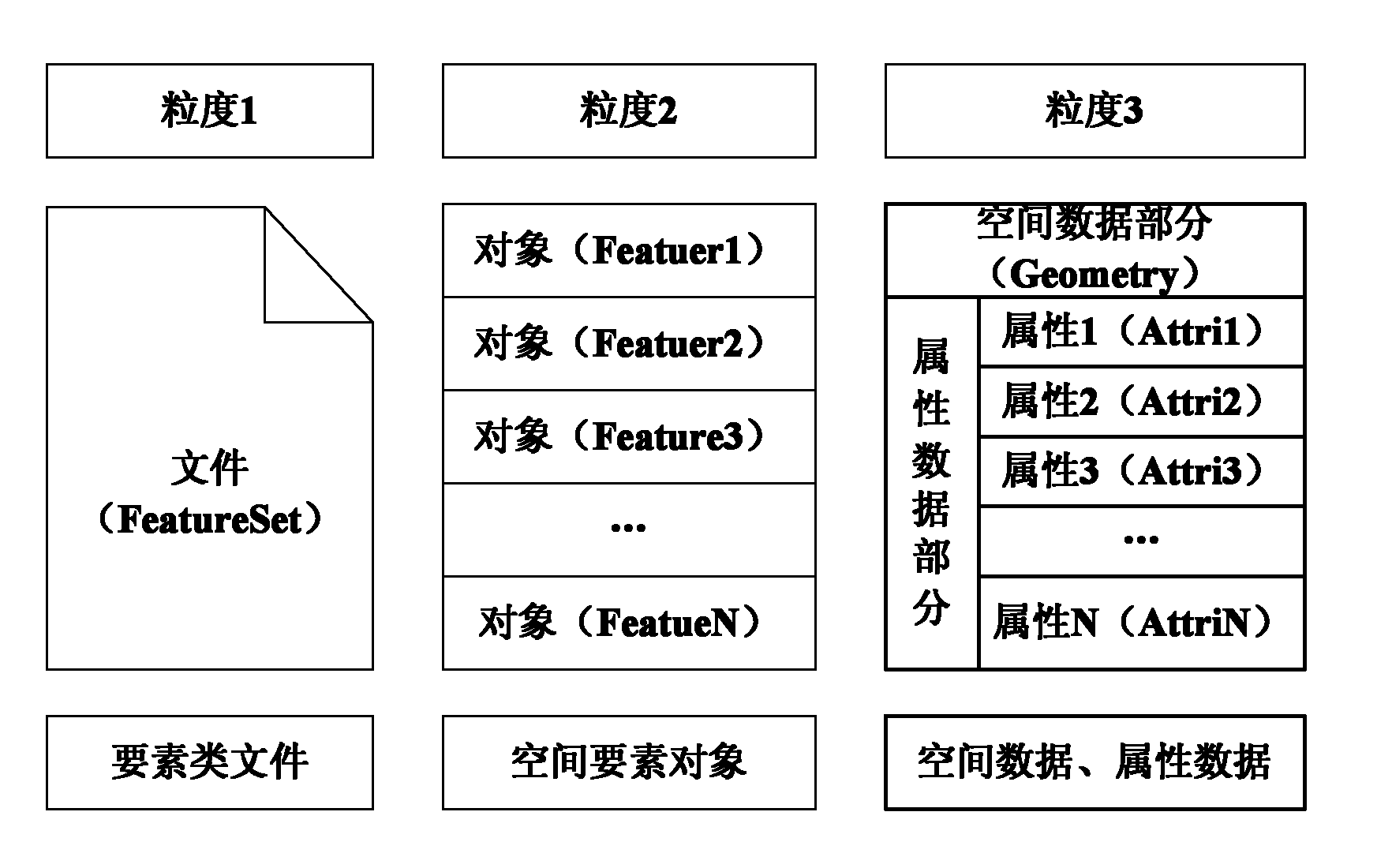
[0045] The file system-based three-dimensional spatial data storage management method is based on the file system and uses data as the core to jointly apply various technologies. Its design and development follow the design principles and methods of the file system for storing three-dimensional spatial data. System-based, unified management of spatial information and attribute information as the core design idea,

[0046] The file system-based 3D spatial data storage management method takes a single storage file as a unit, and stores all objects in 3D space, such as road models, pipeline models, buildin...


PUM


Abstract

The invention relates to the technical field of three-dimensional spatial data storage, in particular to a three-dimensional spatial data storage and management method based on a file system. An object-oriented method and a through based on the file system are adopted for the design and the development of the three-dimensional spatial data storage and management method used to uniformly store the spatial data and the attribute data of a three-dimensional spatial object entity in a file and effectively obtain the spatial data and the attribute data through a file stream technology. The thoughts of classified storage, incremental superaddition, index management and real-time scheduling are adopted to realize core technologies, such as overground and underground as well as indoor and outdoor three-dimensional spatial data integrated management, high-efficiency three-dimensional spatial indexing, dynamic scheduling and the like. The invention has the advantages of high-efficiency processing and flexible management and can be compatible with a large spatial database system to supply basic-level support for the management and the application of a three-dimensional spatial database.

Description

technical field [0001] The invention relates to the technical field of three-dimensional spatial data storage, in particular to a method for storing and managing three-dimensional spatial data based on a file system. Background technique [0002] With the rapid development of space technology, the development of 3D GIS has drawn more and more attention from people. In addition to the characteristics of general spatial data, 3D spatial data is also reflected in various attributes such as semantics, geometry, and texture of spatial objects, complex interrelationships, and huge data volumes. Geospatial data has the characteristics of multi-source, multi-type, multi-dimensional, multi-quantity, multi-temporal, multi-theme and multi-level of detail expression, making the storage, management and updating capabilities of geospatial data the key to the success of 3D GIS applications. Therefore, researching a storage management method for 3D spatial data has become a difficult point...

Claims


Application Information

Patent Timeline
IPC IPC(8): G06F17/30
Inventor 吴冲龙刘刚何珍文翁正平孙卡田宜平张夏林刘圆圆王玭茜李晶彭元崔运涛刘延婷李莹莹周涛
Owner CHINA UNIV OF GEOSCIENCES (WUHAN)
Learn More