Satellite information operational method for global positioning system device

A technology of global positioning system and satellite information, which is applied in the direction of beacon systems using radio waves, etc., can solve the problem of increasing the time of calculation

Inactive Publication Date: 2010-07-07
ALTEK CORP
View PDF0 Cites 0 Cited by
  • Summary
  • Abstract
  • Description
  • Claims
  • Application Information

AI Technical Summary

Problems solved by technology

[0004] Generally speaking, according to the sampling frequency of the wireless signal, the GPS device accumulates all the sampling points in units of 1 millisecond to obtain satellite information. However, the above-mentioned process needs to be completed through a large number of calculation procedures. For example, the received After the satellite signal is processed by analog / digital conversion, it becomes a series of digital data containing "0" and "1". Then, the digital data is mutually exclusive or (XOR) with the carrier frequency and the C / A code, and then the Accumulation operation, used to obtain satellite information, in other words, as the number of digital data increases, the operation time also increases

Method used


Image

  • Satellite information operational method for global positioning system device
  • Satellite information operational method for global positioning system device

Examples


Embodiment Construction

[0014] The technical solutions of the present invention will be further described in more detail in conjunction with the accompanying drawings and specific embodiments.

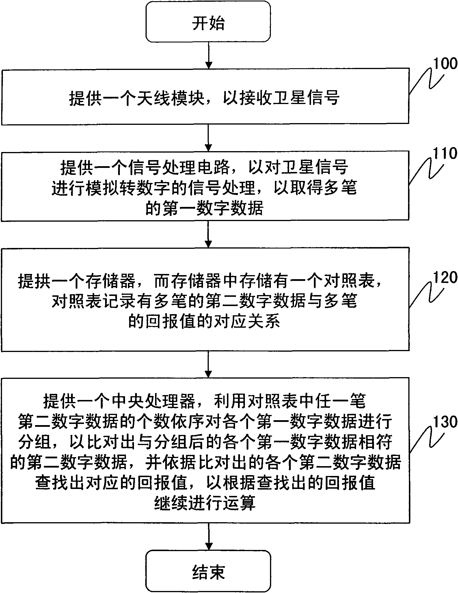
[0015] Please refer to figure 1 , is a flowchart of the method steps of the present invention. like figure 1 As shown, the satellite information calculation method of the global positioning system device of the present invention includes the following steps:

[0016] First, an antenna module is provided to receive satellite signals (step 100). The antenna module may include a patch antenna (Patch Antenna), a passive bandpass filter, a low noise amplifier (Low Noise Amplifier, LNA), a mixer and an IF filter. After receiving the satellite signal through the patch antenna, the passive bandpass filter will filter out the interference signal or noise outside the desired signal frequency band, then use the low noise amplifier to amplify the signal, and then reduce the RF signal to the middle frequency band throu...


PUM


Abstract

The invention discloses a satellite information operational method for a global positioning system device. The method comprises the following steps of: providing a antenna module for receiving satellite signals; providing a signal processing circuit for performing analog-to-digital signal processing on the satellite signals and acquiring a plurality of packets of first digital data; providing a memory which stores a check list, wherein the check list records corresponding relations between a plurality of packets of second digital data and a plurality of packets of return values; and providing a central processing unit for grouping each of the first digital data in turn by utilizing number of any packet of the second digital data in the check list so as to obtain each of the second digital data corresponding to each of the grouped first digital data through comparison, and searching out each corresponding return value according to each obtained second digital data through comparison to calculate continuously according to each searched return value.

Description

technical field [0001] The invention relates to a satellite information computing method, in particular to a satellite information computing method of a global positioning system device. Background technique [0002] The Global Positioning System (GPS) device utilizes the basic triangulation principle of satellites. From the location of each satellite, measure the distance between each satellite and the GPS device, and then calculate the three-dimensional space coordinate value of the location of the GPS device. When the GPS device receives a satellite signal, it can be converted into the distance between the position and the satellite through the internal microprocessor. When receiving two satellite signals, the GPS device can calculate a plane coordinate information. When the third satellite signal is received, the location coordinate information can be calculated. A general GPS device utilizes receiving more than 4 satellite signals to determine the location and altitu...

Claims


Application Information

Patent Timeline
IPC IPC(8): G01S1/04
Inventor 陈宏升
Owner ALTEK CORP
Why Eureka
Try Eureka