Channel ground grid model representation method based on double-layer regularization

A ground grid and grid technology, applied in the field of channel ground grid model representation based on double-layer regularization, can solve problems such as high algorithm complexity, data redundancy, and unfavorable handling of large-scale terrain

Inactive Publication Date: 2009-04-01
HOHAI UNIV
View PDF0 Cites 12 Cited by
  • Summary
  • Abstract
  • Description
  • Claims
  • Application Information

AI Technical Summary

Problems solved by technology

The disadvantages of regular grid DEM are: there is data redundancy in places with flat terrain; it is difficult to express the mutation phenomenon of complex terrain without changing the grid size
Its disadvantage is: the storage method of TIN is complicated, it not only needs to store the elevation of each point, but also store its plane coordinates, topological relationship of node connection, triangle and adjacent triangle and other relationships
The complexity of the algorithm is high, and the block processing is difficult, which is not conducive to the processing of large-scale terrain
Its network is completely based on sampling terrain points, and the terrain resolution cannot be adjusted, which is difficult to meet the observation needs

Method used


Image

  • Channel ground grid model representation method based on double-layer regularization
  • Channel ground grid model representation method based on double-layer regularization

Examples


Embodiment Construction

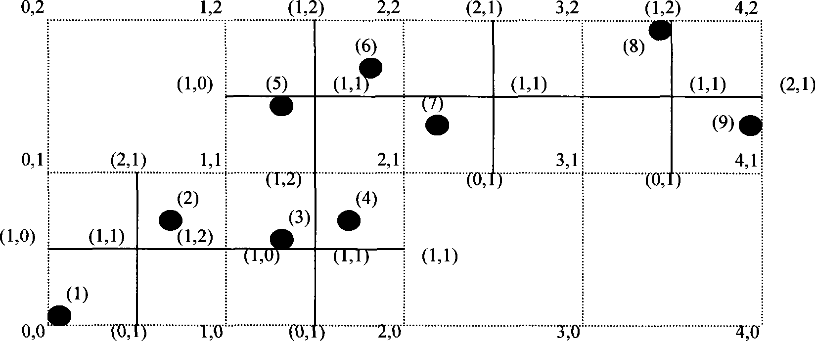
[0034] Such as figure 1 , figure 2 shown. A representation method for the channel ground grid model based on double-layer regularization, which divides all the ground models passed by the channel into regular quadrilateral grids of equal size according to their X and Y coordinates, called external grids, so that the entire ground can be Is divided into the form of a grid consisting of rows and columns. Traversing through whether there are measured terrain data points in each external grid, if any data points fall into the grid, the grid is further divided into small cells according to the cell width input by the user, which is called the internal grid . According to the measured terrain point data, the elevation value of each vertex of the external grid and the internal grid can be calculated in advance, and the vertex coordinates and elevation data information can be stored in the array of the internal grid and the external grid, which can be used Grid coordinates and ve...


PUM


Abstract

The invention discloses a method for expressing a canal terrestrial grid model based on double-layer regularization, and pertains to the method for expressing terrestrial grid models. The terrain where a channel passes through is divided into equal quadrangular grids according to X coordinate and Y coordinate thereof, the quadrangular grids are named as external grids; the complete terrain is divided into a form of determinant grids. Each external grid is examined whether the external grid has measured terrain data point, if a data point is in a grid, then the external grids are further divided into small cells, the small cells are named as internal grids. The elevation value of each peak in the external grids and the internal grids can be computed in advance according to the measured terrain data points, and the peak coordinate and the elevation data information are stored in an array of the internal grids and external grids; in this way, the terrain elevation of an arbitrary point can be computed in a real time manner by the grid coordinate and the peak elevation. The method can adjust the terrain resolution and express jumping phenomenon of complex terrain.

Description

technical field [0001] The invention relates to a representation method for a ground grid model, in particular to a representation method for a channel ground grid model based on double-layer regularization. Background technique [0002] At present, there are three main expression methods of digital elevation model (DEM): triangulated irregular network (TIN), regular grid (GRID) and contour line, among which the first two are the most widely used structural forms. [0003] The regular grid is usually a square, and it can also be a regular grid such as a rectangle or a triangle. The regular grid divides the area space into regular grid units, and each grid unit corresponds to a value. This value can represent the elevation value of all vertices of the grid unit, and can also be considered as the elevation value of the grid center or the average elevation value of the vertices. [0004] In digital terrain modeling, triangular irregular meshes approximate terrain surfaces by ...

Claims


Application Information

Patent Timeline
Patent Type & Authority Applications(China)
IPC IPC(8): G06T17/50G06T17/20G06T17/05
Inventor 薛联青程光靳宏昌
Owner HOHAI UNIV
Why Eureka
Try Eureka