
Method for evaluating city road net traffic state based on floating vehicle data

A floating car data and traffic state technology, applied in data processing applications, road network navigators, traffic flow detection, etc., can solve the problem of not considering road geometry and traffic attributes, unable to assist decision-making in traffic control and management, and not suitable for public release and other problems, to achieve the effect that the operating conditions are easy to meet, the technology is simple and easy to implement, and it is easy to popularize and apply

Inactive Publication Date: 2009-02-25
TONGJI UNIV
View PDF0 Cites 81 Cited by
  • Summary
  • Abstract
  • Description
  • Claims
  • Application Information

AI Technical Summary

Problems solved by technology

[0003] The current commonly used road network state estimation technology usually does not consider the geometric shape and traffic attributes of the road. It only fits the driving speed distribution curve of the GPS data, and uses the driving speed instead of the travel speed as the travel speed to evaluate the smoothness of the road. , there must be a certain gap between the analysis results and the actual road operation status, which is not suitable for public release, nor can it provide effective auxiliary decision-making for traffic control and management

Method used


Image

  • Method for evaluating city road net traffic state based on floating vehicle data
  • Method for evaluating city road net traffic state based on floating vehicle data
  • Method for evaluating city road net traffic state based on floating vehicle data

Examples


Embodiment Construction

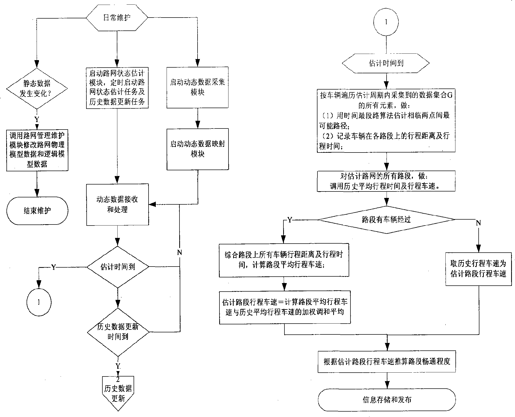
[0051] This method is a method for dynamically estimating the road network traffic state based on the current situation combined with historical data. The accumulation of historical data takes a long time, and with the accumulation of historical data, the estimation results are more accurate. Another important premise of this method is the collection, sorting and maintenance of road network static data. The finer the granularity of the collected data, the better the estimation results.

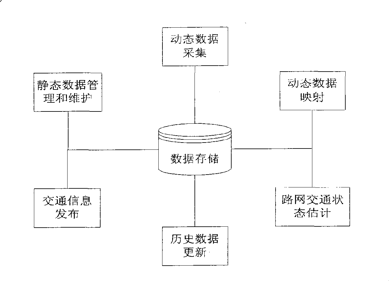
[0052] Such as figure 1 As shown, the system consists of static data management and maintenance module, dynamic data acquisition module, dynamic data to logical road network mapping module, road network traffic state estimation module, historical data update module, traffic information release module, and data storage module. These software modules are independent and can be installed on one machine or multiple machines according to the actual situation. The physical deployment is as follows: ...


PUM


Abstract

The invention relates to a method for evaluating traffic jam, congestion and smooth state of urban roads by using floating vehicle data. Concretely, the method comprises the following steps: analyzing the transmission frequency and the traveling tracks of data based on the prior GPS data by using network state estimation technique based on GPS data of floating vehicles in detail; selecting a comprehensive evaluation value of the calculation result of a time shortest path algorithm as the traveling speed of the road in consideration of the OD characteristics of the urban traffic; and comprehensively evaluating the traffic state of the road by using fuzzy reasoning technique based on the combination of the traveling speed and the use function of the road. The improved evaluation method has the advantages of easily satisfied operation condition, easy implementation, and accurate result.

Description

technical field [0001] The invention relates to a method for evaluating urban road traffic congestion, congestion and unimpeded state by using floating car data. Background technique [0002] The state of urban road traffic is generally described by parameters such as travel time, travel speed, smoothness, and service level. Both the fixed coil detection technology and the floating car technology can realize the derivation of the above parameters. Compared with the limited coverage and high cost of the fixed coil detection technology, the floating vehicle technology has the advantages of wide coverage, low application cost, and easy promotion. It is a dynamic traffic information collection technology commonly used in traffic information service systems in recent years. Floating vehicles based on GPS information can generally record the vehicle's ID, time coordinates, earth space coordinates, speed, direction and business information related to the GPS navigation system in r...

Claims


Application Information

Patent Timeline
IPC IPC(8): G08G1/01G06Q50/00G01C21/34
Inventor 杨晓光吴志周童梅赵靖
Owner TONGJI UNIV
Learn More