Multi-satellite remote sensing data integrated parallel ground pretreatment system

A technology of satellite remote sensing data and data processing, which is applied in the direction of radio wave measurement system, electromagnetic wave re-radiation, utilization of re-radiation, etc., to achieve the effect of increasing the operating speed

Inactive Publication Date: 2008-12-03
CENT FOR EARTH OBSERVATION & DIGITAL EARTH CHINESE ACADEMY OF SCI
View PDF0 Cites 22 Cited by
  • Summary
  • Abstract
  • Description
  • Claims
  • Application Information

AI Technical Summary

Problems solved by technology

[0004] The purpose of the present invention is to provide a multi-satellite remote sensing data integrated parallel ground preprocessing system to solve the problem of multi-level products of multi-satellite data and rapid processing of massive data

Method used


Image

  • Multi-satellite remote sensing data integrated parallel ground pretreatment system

Examples


Embodiment Construction

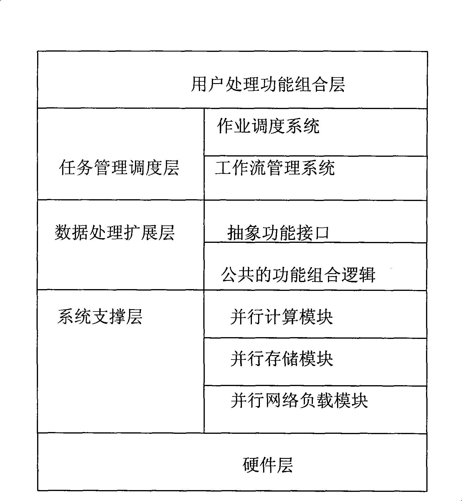
[0015] Such as figure 1 As shown, the multi-satellite remote sensing data integrated parallel ground preprocessing system according to the embodiment of the present invention includes a hardware layer, a system support layer, a data processing expansion layer, a task management scheduling layer, and a user processing function combination layer; the hardware layer provides The hardware support of the preprocessing system, including commercial cluster systems, storage systems such as SAN / NAS, and hardware facilities such as high-performance network systems such as Gigabit Ethernet or infiniband; system support layer, provides system software support environment, and focuses on system performance expansion , Through orthogonal design to achieve parallel computing, parallel storage, parallel network load modules, so that the system can be independently expanded in terms of processing performance, network performance, and storage performance, and can comprehensively optimize the perfor...


PUM


Abstract

The invention relates to an integrated parallel ground preprocessing system for multi-satellite remote sensed data. The system comprises a hardware layer, a system supporting layer, a data processing and expanding layer, a task managing and dispatching layer and a user processing function combining layer, wherein the hardware layer provides hardware support for the preprocessing system; the system supporting layer provides a software support environment for the system; the data processing and expanding layer is provided with abstract function interfaces and public function combinational logics of various satellites and various sensors; the task managing and dispatching layer is used for realizing task dispatching and flow management; and the user processing function combining layer provides simple and practical flow combination interfaces for users. The preprocessing system has the advantages that the users can conveniently and uniformly expand processing, memory and network communication capacities of the system without modifying the processing program, thereby increasing the operating speed of the program; when new satellite remote sensed data enter the system and require processing, archiving, product production and distribution, function expansion can be completed only by adding processing modules of corresponding data into the system according to a certain template.

Description

Technical field [0001] The invention relates to the technical field of ground preprocessing of remote sensing data, in particular to a high-performance multi-satellite remote sensing data ground preprocessing system based on a parallel cluster architecture. Background technique [0002] The remote sensing satellite ground preprocessing system is a comprehensive system integrating satellite data archiving and management, data preprocessing and product generation. It is an important support system for the space earth observation system and the link between the acquisition of related space data and ground applications. With the rapid development of information technology and sensor technology, the spatial resolution, spectral resolution and time resolution of satellite remote sensing images have been greatly improved. The amount of data collected on the satellite has increased by 100-400 times, and the corresponding data processing calculation has also increased by 1000- 10,000 time...

Claims


Application Information

Patent Timeline
Patent Type & Authority Applications(China)
IPC IPC(8): G01S7/48G01S17/00
Inventor 刘定生李国庆章文毅李景山赵灵军马艳王建陈甫黄克颖杨进黄鹏黄方马广彬于文洋张万军
Owner CENT FOR EARTH OBSERVATION & DIGITAL EARTH CHINESE ACADEMY OF SCI
Why Eureka
Try Eureka