
Spatial information capturing device

a spatial information and capture device technology, applied in measurement devices, instruments, optics, etc., can solve the problems of high computing cost, high computational load, and high complexity of software computing technology, and achieve the effect of effectively acquiring spatial distance information of a target object, simplified structure of spatial information capture devices, and simplified processing procedures of associated controllers

Active Publication Date: 2018-05-22
EVERREADY PRECISION IND
View PDF5 Cites 0 Cited by
  • Summary
  • Abstract
  • Description
  • Claims
  • Application Information

AI Technical Summary

Benefits of technology

[0006]An object of the present invention provides a spatial information capturing device capable of effectively acquiring a spatial distance information of a target object in an efficient way. The structure of the spatial information capturing device is thus further simplified. Consequently, the processing procedure of the associated controller is simplified, and then, the cost is reduced.
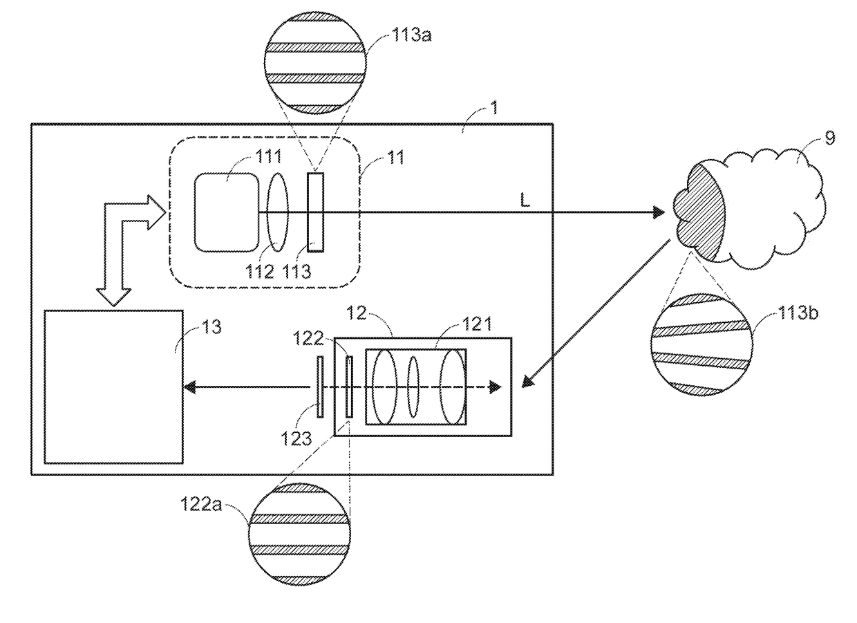
[0020]From the above descriptions, the spatial information capturing device of the present invention is equipped with the optical encoder. The optical encoder has the reference pattern. The evaluation pattern is generated by the structured light generation module and formed on the target object. The reference pattern and the evaluation pattern have at least one corresponding pattern feature. The reference pattern and the evaluation pattern can be simultaneously projected onto the sensing unit. By comparing the pattern feature difference between the reference pattern and the evaluation pattern, the process controller realizes a spatial distance information of the target object. Since it is not necessary to previously store the contents of the reference pattern into the process controller, the additional installing time and the additional labor cost are saved. Moreover, since the processing procedure of the process controller is simplified, the computing and comparing speed will be increased and the computing cost will be reduced.

Problems solved by technology

However, when the TOF measurement method is expanded to the planar scenario application or the multi-point scenario application, the software computing technology is very complicated and computational load is heavy.
Moreover, the additional uses of the specified computing chip and integrated circuits (ICs) require lot of power consumption and high computing cost.
Moreover, the TOF measurement method is readily affected by the ambient brightness.
If the light pollution in the surroundings is serious, the accuracy of the measured result is low.
On the other hand, the software computing technology for the dual camera distance measurement method is somewhat complicated and not easier.
However, since the performance of measuring the distance from the smooth surface by the dual camera distance measurement method is inferior, the measured result about the distance from the smooth surface has lower accuracy.

Method used


Image

  • Spatial information capturing device
  • Spatial information capturing device
  • Spatial information capturing device

Examples


Embodiment Construction

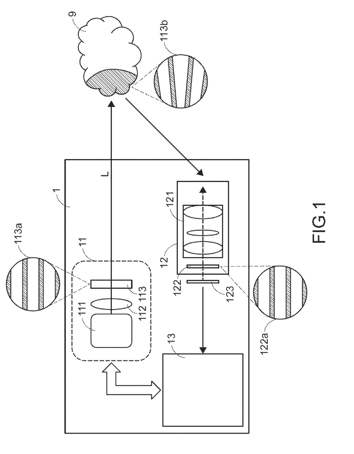
[0026]FIG. 1 schematically illustrates a spatial information capturing device for evaluating a target object according to an embodiment of the present invention.

[0027]The spatial information capturing device 1 is capable of capturing a spatial information of a target object. In this context, the spatial information contains the height and depth relative to the surface of the target object, the distance between the target object and the spatial information capturing device and any other appropriate spatial information. The spatial information is helpful to create the three-dimensional image. The method of calculating the three-dimensional image in the back-end side is well known to those skilled in the art, and is not redundantly described herein.

[0028]As shown in FIG. 1, the spatial information capturing device 1 comprises a structured light generation module 11, a camera module 12 and a process controller 13. For capturing the spatial information of a target object 9, the structure...


PUM

PropertyMeasurementUnit
spatial distanceaaaaaaaaaa
structuresaaaaaaaaaa
liquid crystal structuresaaaaaaaaaa

Abstract

A spatial information capturing device includes a structured light generation module, a camera module and a process controller. The structured light generation module provides a structured light pattern to a target object, so that an evaluation pattern is formed on the target object. The camera module includes a lens group, an optical encoder and a sensing unit. The optical encoder has a reference pattern. The reference pattern and the evaluation pattern have at least one corresponding pattern feature. In addition, both of the reference pattern and the evaluation pattern are projected on the sensing unit. The process controller compares a pattern feature difference between the reference pattern and the evaluation pattern, and realizes a spatial distance information of the target object according to a result of comparing the pattern feature difference. Hence, the configuration or structure of the spatial information capturing device is simplified.

Description

FIELD OF THE INVENTION[0001]The present invention relates to a spatial information capturing device, and more particularly to a spatial information capturing device including a structured light generation module to generate a pattern and a camera module to capture the pattern in order to extract a spatial information efficiently.BACKGROUND OF THE INVENTION[0002]Recently, with the development of electronic industries and the advance of industrial technologies, various electronic devices are designed and produced toward small size, light weightiness and easy portability. Consequently, these electronic devices can be applied to mobile business, entertainment or leisure purposes whenever or wherever the users are. In these devices, probably the image-taking devices are most widely used as appeared in many kinds of fields, such as smart phones, wearable electronic devices or any other appropriate electronic apparatus. These imaging devices are attractive to daily applications for human b...

Claims


Application Information

Patent Timeline
Patent Type & Authority Patents(United States)
IPC IPC(8): G02F1/137G01B11/25
CPCG02F1/137G01B11/2513H04N13/254H04N13/204H04N13/271
Inventor CHERN, JYH-LONGYEN, CHIH-MING
Owner EVERREADY PRECISION IND
Learn More