Method and system for fuel route planning

a fuel route and route planning technology, applied in the field of aviation fuel route planning, can solve the problems of lack of coordination and efficiency of supply and demand of aviation fuel, difficulty in planning, and inability to centralize the day-to-day information of fuel information, etc., and achieve the effect of improving demand forecasting, fuel inventory management, and increasing fuel inventory turnover

Active Publication Date: 2014-04-15
CARRITHERS JEFFREY A
View PDF46 Cites 17 Cited by
  • Summary
  • Abstract
  • Description
  • Claims
  • Application Information

AI Technical Summary

Benefits of technology

The present invention is a system and method that allows aircraft owners, pilots, dispatchers, and flight department managers to easily secure the most economic fuel supply and make better routing decisions to make fuel route planning more economical, efficient, and predictable. This results in increased efficiencies in the operations of the aircraft by allowing dispatchers to route their flights into airports with the best fuel prices. The system gives the user a graphical display with fuel options within range of an aircraft along the flight trajectory of the aircraft. Additionally, the system also has features and advantages for the supply side (FBOs), allowing smaller and less well known FBOs to be competitive with larger regional airports' FBOs. The fuel route planning system enables making fuel reservations by aircraft owners or flight dispatchers, securing fuel availability for FBOs, which results in improved demand forecasting, fuel inventory management, and higher fuel inventory turnover. Overall, the system enhances fuel efficiency and reliability for aircraft owners and operators.

Problems solved by technology

Fuel costs vary by region and airport and, because of price volatility, are difficult to plan.
Currently, there is no central repository where day-to-day, cost-responsive fuel information comes together as a coherent whole.
As a result, the supply and demand of aviation fuel lacks coordination and efficiency, which makes flying more expensive.
To find a reliable fuel supply at the lowest possible cost is almost impossible because the information is fragmented, dispersed, and not readily accessible.
Especially on multi-stop missions, this effort is excessively time consuming and can become an overwhelming burden in planning flight operations.
Although there are websites that gather and publish some aviation fuel prices at airports, there is no system that integrates this information with geospatial mapping in fuel route planning.
Moreover, these websites do not determine qualified airports based on the range of the aircraft and the flight trajectory from an origin airport.

Method used


Image

  • Method and system for fuel route planning
  • Method and system for fuel route planning
  • Method and system for fuel route planning

Examples


Embodiment Construction

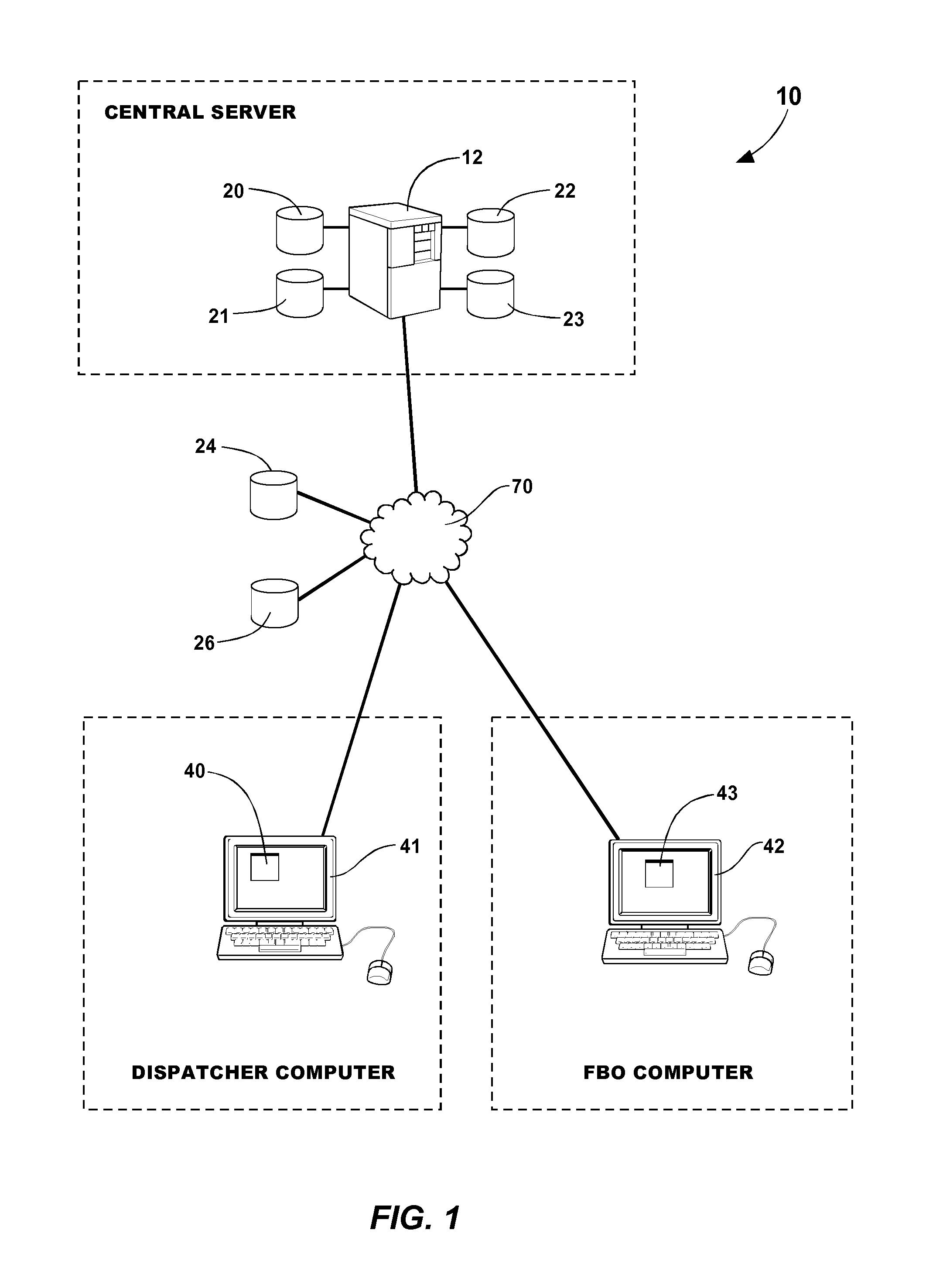
[0045]FIG. 1 is a functional block diagram of an exemplary system 10 for minimizing aviation fuel cost using geospatial mapping in fuel route planning. The exemplary system 10 includes a central server computer 12, a dispatch computer 41 and an FBO computer 42 in communication with each other through a network 70, such as the Internet.

[0046]In communication with the central server computer 12 are: an airport information database 20 for storing airport information such as airport locations and lengths of available runways; an FBO information database 21 for storing FBO information such as fuel types, prices and inventories; and an aeronautical / geospatial mapping information database 22 for storing aeronautical / geospatial mapping information for rendering maps. Of course, any or all of the airport information database 20, the FBO information database 21, and the aeronautical / geospatial mapping information database 22 can be combined into a combined database without departing from the ...


PUM


Abstract

A method for fuel route planning is implemented on a system including: a dispatch computer for interfacing with a fuel route plan user; and a central server computer in communication with the dispatch computer through a network. The central server computer is for: receiving an origin airport and a destination airport for a flight of an aircraft; determining a flight trajectory between the origin airport and the destination airport; retrieving a plurality of refueling airports located adjacent to the flight trajectory; retrieving fuel price information associated with a plurality of FBOs located at the plurality of refueling airports; presenting the flight trajectory and the plurality of refueling airports on an aeronautical / geospatial map; and displaying the fuel price information associated with the plurality of FBOs located at the plurality of refueling airports for use in compiling a fuel route plan.

Description

CROSS-REFERENCE TO RELATED APPLICATIONS[0001]This application claims the benefit of U.S. Provisional Patent Application No. 61 / 083,571, filed Jul. 25, 2008, the entire disclosure of which is hereby incorporated by reference.STATEMENT REGARDING FEDERALLY SPONSORED RESEARCH OR DEVELOPMENT[0002]Not applicable.THE NAMES OF THE PARTIES TO A JOINT RESEARCH AGREEMENT[0003]Not applicable.INCORPORATION-BY-REFERENCE OF MATERIAL SUBMITTED ON A COMPACT DISC[0004]Not applicable.BACKGROUND OF THE INVENTION[0005]1. Field of the Invention[0006]The field of the disclosure relates generally to aviation fuel route planning.[0007]2. Background Art[0008]Aviation fuel is available at Fixed Based Operators (FBOs), located at airports. Fuel costs vary by region and airport and, because of price volatility, are difficult to plan. There are approximately 7,000 FBOs in the USA. In 2006, these FBOs dispensed an estimated 1.4 billion gallons of aviation fuel in the USA, representing $6.3 Billion in revenues.[00...

Claims


Application Information

Patent Timeline
IPC IPC(8): G06F17/00G01C22/00G06F7/00G01C23/00G05D3/00G05D1/00
CPCG06F7/00G06F17/00G05D1/00G05D3/00G06Q10/047G06Q30/02
Inventor CARRITHERS, JEFFREY, A.
Owner CARRITHERS JEFFREY A
Why Eureka
Try Eureka