
Method for processing a set of signals of a global navigation satellite system with at least three carriers

a global navigation satellite and signal processing technology, applied in satellite radio beaconing, measurement devices, instruments, etc., can solve the problems of carrier signals showing so-called ionospheric errors, significant attenuation of ionospheric and tropospheric errors, and ambiguity of phase, so as to minimize the probability of non-detection, minimize the maximum variance, and reduce the probability of erroneous estimation

Active Publication Date: 2012-01-10
DEUTSCHES ZENTRUM FUER LUFT & RAUMFAHRT EV
View PDF5 Cites 18 Cited by
  • Summary
  • Abstract
  • Description
  • Claims
  • Application Information

AI Technical Summary

Benefits of technology

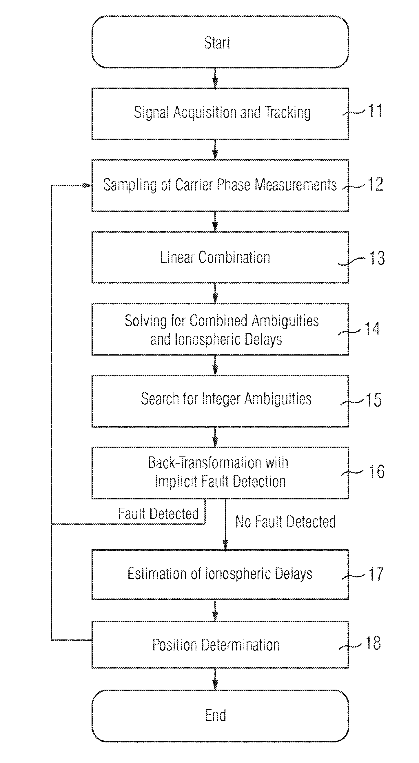
The present invention provides an improved method for processing a set of navigation signals of a global navigation satellite system with at least three carrier signals. The method reduces the number of unknowns and improves the accuracy of positioning the navigation device without using parallel measurements of a reference station. The method involves a combination of carrier signals that eliminates tropospheric error and clock errors of the satellite as well as the orbital errors of the satellites. The method also compensates for the rank deficit of geometry-free linear combinations by adding an additional phase measurement. The estimation process can be further improved by using a combination matrix that minimizes the probability for the non-detection of a fault estimation and by taking into account second order disturbance variables. The technical effects of the invention include improved accuracy and efficiency in navigation and positioning.

Problems solved by technology

One disadvantage of a positioning process using the carrier signals is the ambiguity of the phase since the carrier signal contains no information on the integer number of wavelengths between the navigation device and the satellite.
In consequence the carrier signals show a so called ionospheric error.
Further error sources are the phase noise of the carrier signal, the orbital error of the satellite as well as the clock error of the navigation device and the satellite.
In addition ionospheric and tropospheric errors are significantly attenuated for short baselines if the double difference method is used.
Typically, the ionospheric error results in a spatial error of a few meters, whereas the phase noise affects the results of the phase estimation by a few millimeters.
The disadvantage of the prior art cascade integer ambiguity resolution is the repetitive estimation of the baseline which is a nuisance parameter in all steps except the last one.
The E5a-E5b combination benefits from a significant reduction of the ionospheric error but shows a severe drawback: The superposition of ambiguities can no longer be expressed as an integer multiple of a single wavelength.

Method used


Image

  • Method for processing a set of signals of a global navigation satellite system with at least three carriers
  • Method for processing a set of signals of a global navigation satellite system with at least three carriers
  • Method for processing a set of signals of a global navigation satellite system with at least three carriers

Examples


Embodiment Construction

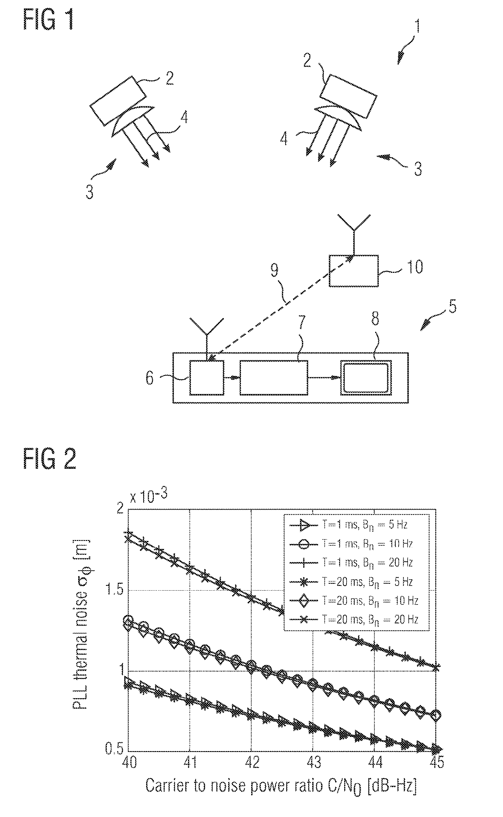
[0048]FIG. 1 shows a global navigation satellite system 1 which comprises satellites 2 orbiting around the earth and emitting navigation signals 3 modulated on a number of carrier signal 4.

[0049]A navigation device 5 comprises a receiver 6 which is connected to a signal processor 7. The signal processor 7 processes the navigation signal 3 received from the satellites 2 and display the results on a display 8 of the navigation device 5.

[0050]For determining the position of the navigation device 5 various methods can be used. In the double difference method the length d of a baseline vector 9 between the navigation device 5 and a reference station 10 is determined by considering the differences between current difference signals from different satellites 2, whereas the difference signals are formed by the differences between the signals emitted by a specific satellite 2 but received from the navigation device 5 and the reference station 10. The distance between the navigation device 3 ...


PUM


Abstract

A method for processing a set of navigation signals of a global navigation satellite system with at least three carrier signals is disclosed in which the processing of the navigation signals is based on a linear combination of the carrier signals to a combined signal. The weighting coefficients are selected such that the combined phase signal is free from geometry and free from frequency-independent disturbance variables.

Description

CROSS-REFERENCE TO RELATED APPLICATIONS[0001]The present application is a continuation of pending International patent application PCT / EP2008 / 053300 filed on Mar. 19, 2008, which claims priority of European application No. 07005970 filed on Mar. 22, 2007, priority of European application No. 07009091, filed on May 4, 2007 and priority of European application No. 07112009, filed on Jul. 7, 2007. The disclosure of this application is hereby incorporated by reference in its entirety, as part of the present disclosure.FIELD OF THE INVENTION[0002]The invention relates to a method for processing a set of navigation signals of a global navigation satellite system with at least three carrier signals in which the processing of the navigation signals is based on a linear combination of phase measurements of the carrier signals to a combined phase signal.BACKGROUND OF THE INVENTION[0003]Such a method is known from ZHANG, H.: Triple frequency Cascading Ambiguity Resolution for Modernized GPS an...

Claims


Application Information

Patent Timeline
Patent Type & Authority Patents(United States)
IPC IPC(8): G01S19/44G01S19/33G01S19/32G01S5/14
CPCG01S19/44
Inventor HENKEL
Owner DEUTSCHES ZENTRUM FUER LUFT & RAUMFAHRT EV
Learn More