
Method for image data processing

a data processing and image technology, applied in the field of image data processing, can solve the problems of lle not being able to discover the optimal global coordinate system, ignoring the inherent nonlinear characteristics of hyperspectral data, and reducing so as to improve the classification performance and compression, and reduce the computational and memory cost

Inactive Publication Date: 2010-07-13
THE UNITED STATES OF AMERICA AS REPRESENTED BY THE SECRETARY OF THE NAVY
View PDF0 Cites 17 Cited by
  • Summary
  • Abstract
  • Description
  • Claims
  • Application Information

AI Technical Summary

Benefits of technology

This approach allows for efficient classification and compression of hyperspectral data, overcoming the scalability issues of previous methods and facilitating the development of scene-level manifold coordinate products for various applications, including DOD and civilian remote sensing.

Problems solved by technology

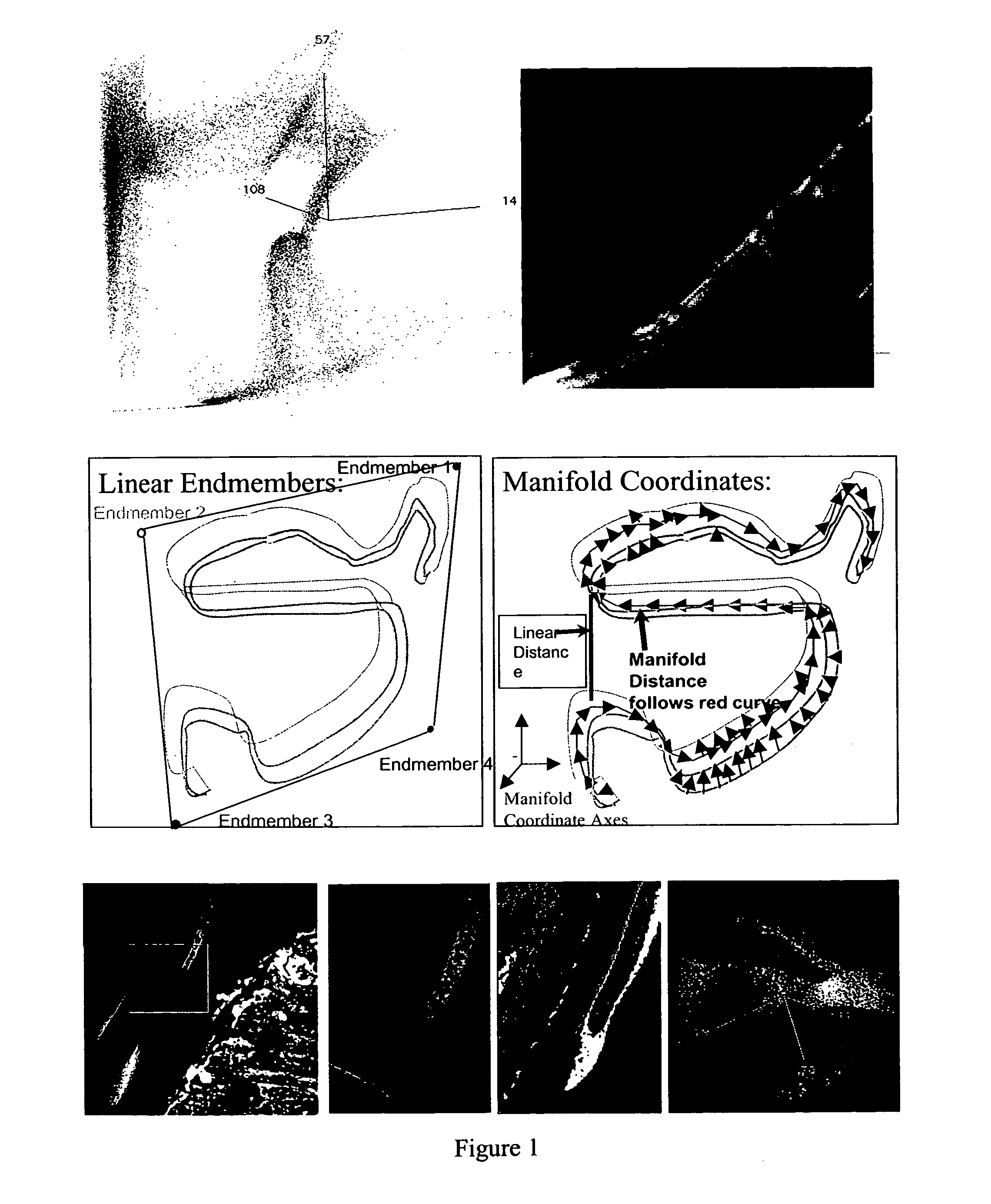
Although the use of endmembers and indexes based on narrowband features have yielded very useful results, these approaches largely ignore the inherent nonlinear characteristics of hyperspectral data.
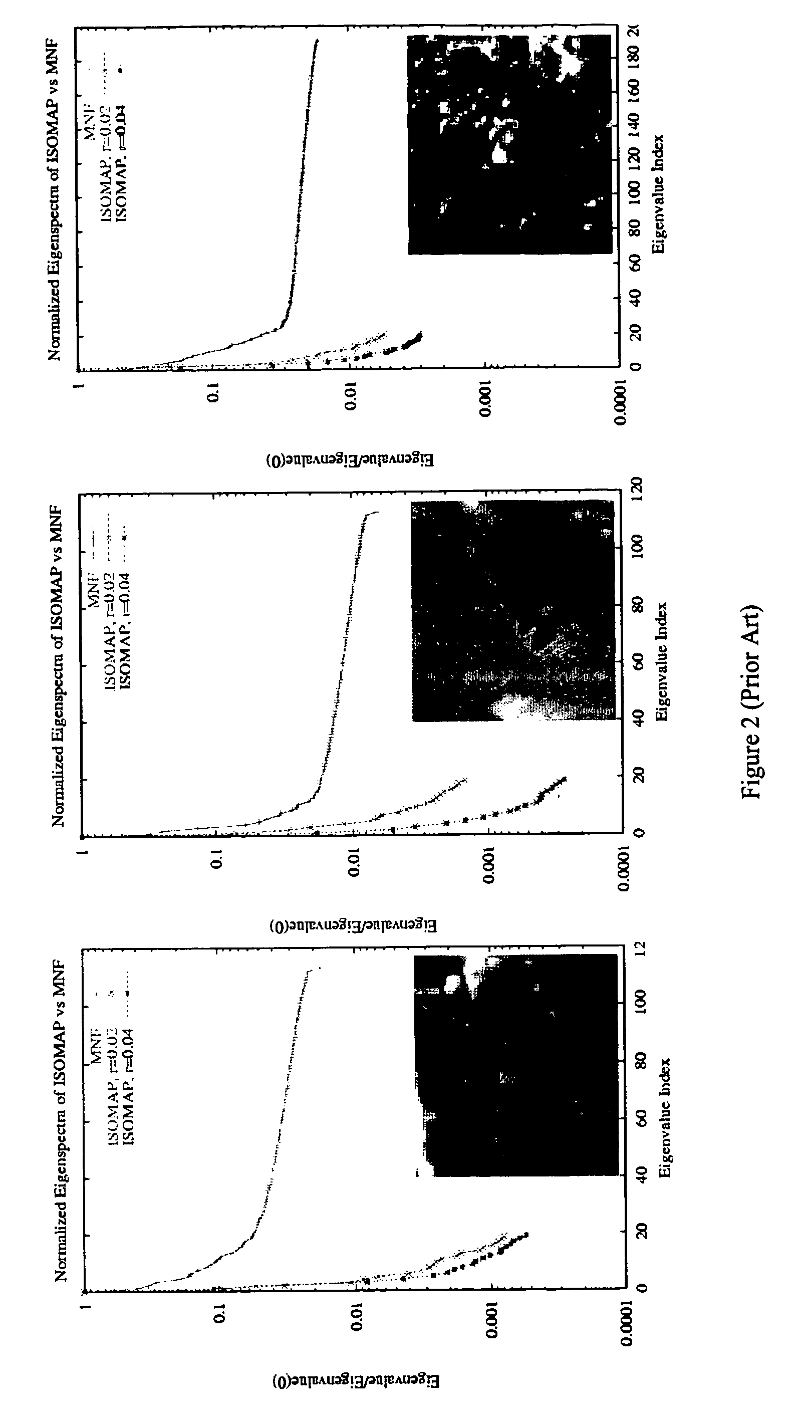
Another significant computational challenge is that ISOMAP memory requirements scale as O(N2), because ISOMAP requires the extraction of dominant eigenvectors of an N×N geodesic distance matrix.
Like the Dijkstra implementation of ISOMAP, the largest computational operations in LLE also scale as O(N2 log(N)), however, LLE is not guaranteed to discover the optimal global coordinate system and appears to be more vulnerable to noise (see response of Tenenbaum, de Silva, and Langford in “The ISOMAP algorithm”).
15 869-15 872, December 2002.) because its fundamental computational burden scales as O(N); however, the simplifying assumptions that appear in estimating geodesic distances and the embedded approximation appear to be too weak and have lead to degenerate solutions when applied to hyperspectral data and even in some very simple, artificial problems.
While this is possible, it is certainly more computationally expensive.
In particular, using the prior art algorithms, it is not be possible to develop a general set of manifold coordinates for entire scenes of size O(106) samples or greater, regardless of improvements in processor hardware.
Manifold coordinate representations of large hyperspectral images, O(106) pixels, is not computationally feasible with present techniques.

Method used


Image

  • Method for image data processing
  • Method for image data processing
  • Method for image data processing

Examples


Embodiment Construction

Manifolds

Formal Definitions

[0027]Either explicitly or implicitly, the most fundamental property that is usually exploited in manifold algorithms is that locally a manifold looks like a Euclidean space. This is essentially what is meant by the definition of a “d-dimensional topological manifold,” where, formally, we require that for each point in the manifold M, there is an open subset V with εV, for which there exists a homeomorphic mapping g that maps V into a d-dimensional open subset V′ in a d-dimensional Euclidean space

[0028]

It is this open subset V that we identify as the “neighborhood” in algorithms described herein.

ISOMAP

[0029]Of the extant methods for estimating a global manifold coordinate system, ISOMAP is the only one for which a globally optimal solution can be guaranteed. In the original ISOMAP, all Euclidean distances rij between pairs of data sample points and are calculated. Using the notation in Tenenbaum et al., a connected graph of distances dG(i,j) is first d...


PUM


Abstract

A method for exploiting the nonlinear structure of hyperspectral imagery employs a manifold coordinate system that preserves geodesic distances in the high-dimensional hyperspectral data space. Data representing physical parameters such as a scene is divided into a set of smaller tiles. The manifolds derived from the individual tiles are then aligned and stitched together to complete the scene. Coordinates are derived for a very large although not complete representative subset of the data termed the “backbone”. Manifold coordinates are derived for this representative backbone and then the remaining samples inserted into the backbone using a reconstruction principle using the property of local linearity everywhere on the manifold to reconstruct the manifold coordinates for the samples not originally belonging to the backbone. The output is a global manifold coordinate system, which for topographical image data depicts clearer detail of land and water portions of a scene.

Description

[0001]The present application claims the benefit of the priority filing date of provisional patent application No. 60 / 612,394, filed Sep. 20, 2004, incorporated herein by reference.FIELD OF THE INVENTION[0002]This invention relates to a method and device for processing data such as hyperspectral imaging data. More particularly, the invention relates to a manifold representation technique applied to the nonlinear structure of hyperspectral imagery.BACKGROUND OF THE INVENTION[0003]For many years, linear mixing, for example as described in J. W. Boardman, “Automating spectral unmixing of AVIRIS data using convex geometry concepts,” in Proc. 4th Annu. JPL Airborne Geosciences Workshop, vol. 1, Pasadena, Calif., 1993, JPL Pub. 93-26, pp. 11-4. and “best band” combinations have been de facto standards in the analysis of spectral data, especially hyperspectral. The “best band” approach, for example as described in R. N. Clark, G. A. Swayze, C. Koch, A. Gallagher, and C. Ager, “Mapping vege...

Claims


Application Information

Patent Timeline
Patent Type & Authority Patents(United States)
IPC IPC(8): G06K9/62G06V20/13
CPCG06K9/0063G06K9/6252G06V20/13G06V10/7715G06F18/21375
Inventor BACHMANN, CHARLES MAINSWORTH, THOMAS L
Owner THE UNITED STATES OF AMERICA AS REPRESENTED BY THE SECRETARY OF THE NAVY
Learn More