Pedestrian traffic monitoring and analysis

a technology for pedestrians and traffic, applied in the field of computer data processing, can solve problems such as large sporting events wreaking havoc on transportation systems

Active Publication Date: 2017-05-11
UNILOC 2017 LLC
View PDF4 Cites 0 Cited by
  • Summary
  • Abstract
  • Description
  • Claims
  • Application Information

AI Technical Summary

Benefits of technology

The present invention is a system that collects information about how people move around in a town or city. This information can be used to create maps that show where people are located in real-time, which can be useful for emergency responders and retailers. The location reports are obtained from mobile devices that people carry with them, and each device is identified anonymously to ensure privacy.

Problems solved by technology

For example, large sporting events can wreak havoc on transportation systems.

Method used


Image

  • Pedestrian traffic monitoring and analysis
  • Pedestrian traffic monitoring and analysis
  • Pedestrian traffic monitoring and analysis

Examples


Embodiment Construction

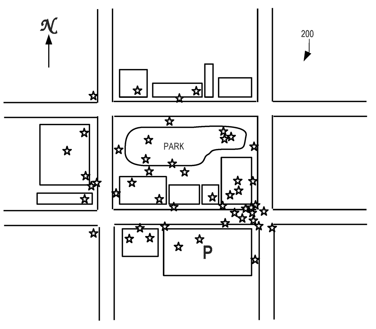
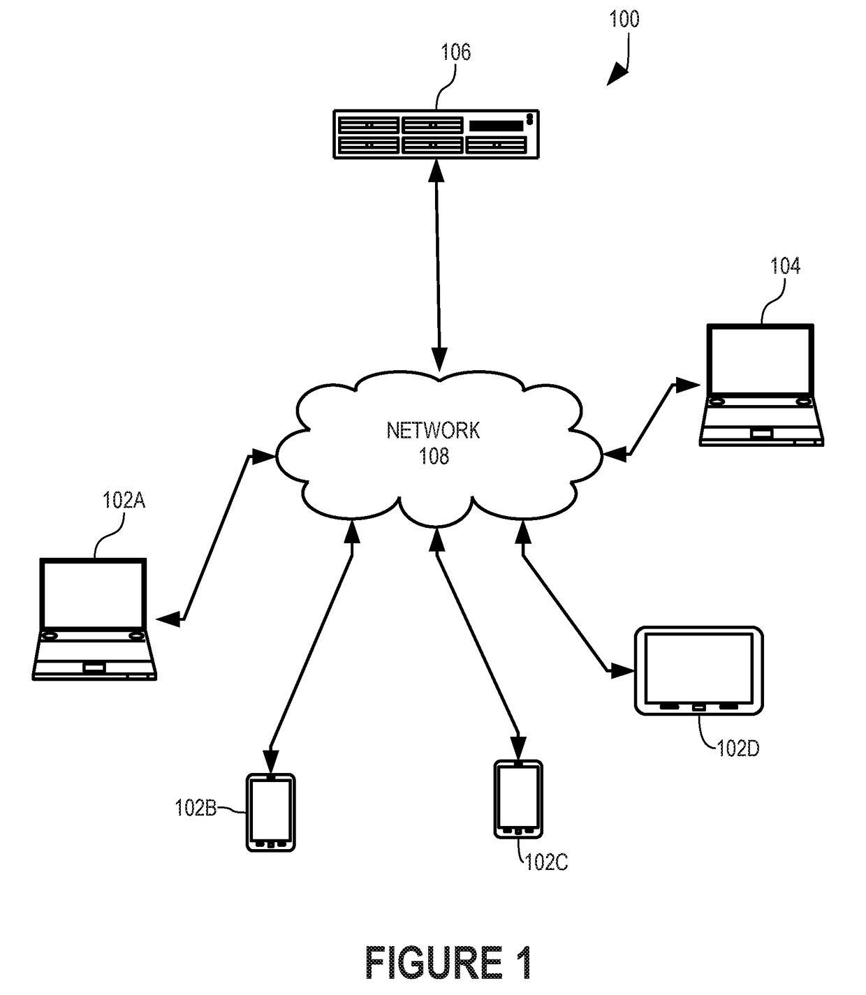
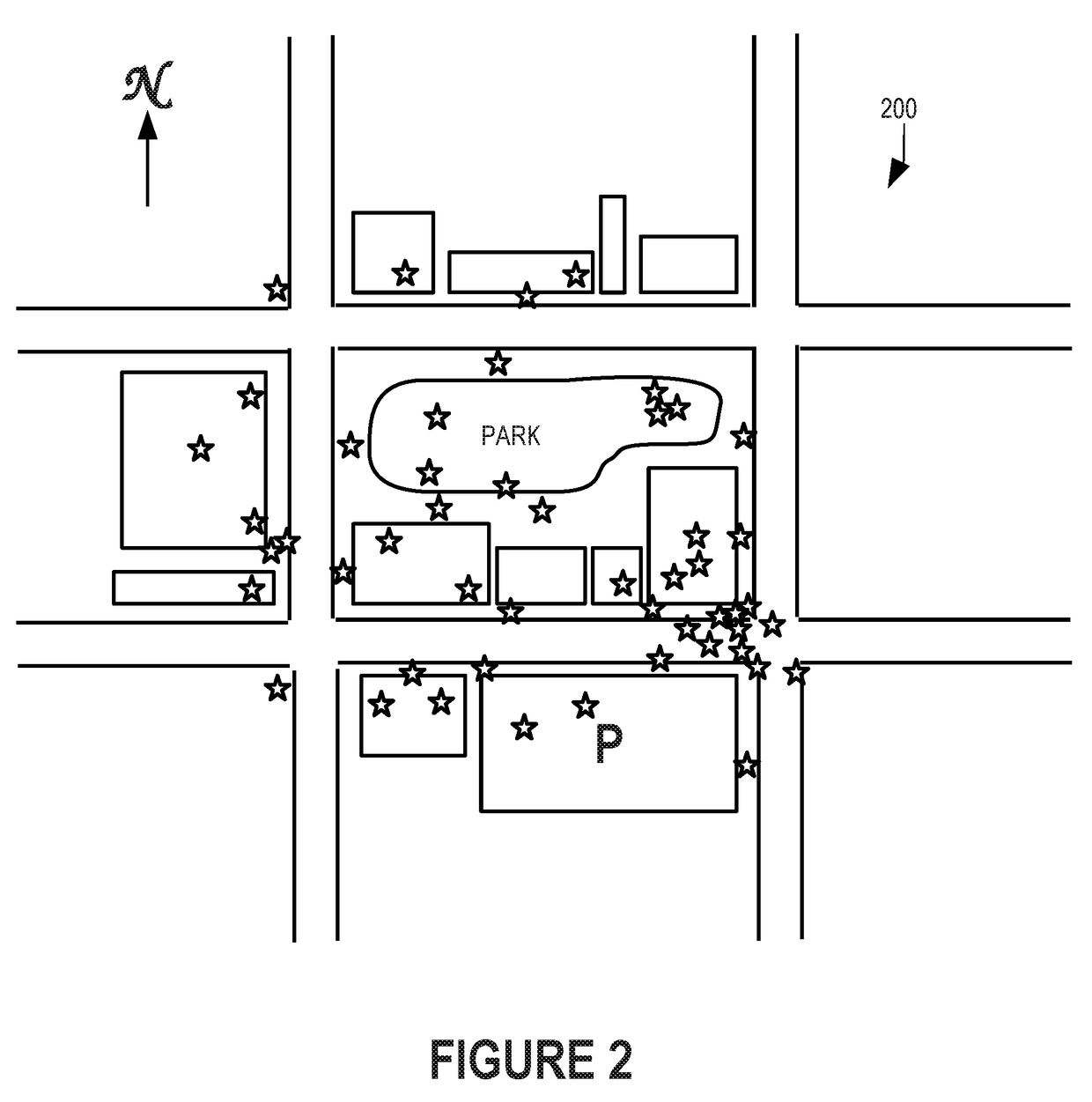
[0027]In accordance with the present invention, a server 106 (FIG. 1) gathers location information from user devices 102A-D, provides instantaneous maps of current pedestrian traffic such as map 200 (FIG. 2), and generates statistical analysis of such location information to provide detailed information regarding typical pedestrian traffic patterns.

[0028]Map 200 is a very simple example of a pedestrian traffic map yet provides valuable information. For example, emergency services can immediately see that the Southeast intersection appears to be blocked by pedestrians and can reroute vehicles in response. The number of people using the park can be determined, both those using the park immediately and how many people use the park on average for various days, weeks, months, and seasons. The number of people using the parking garage at the South of map 200 can be determined, both immediate use and usage patterns. The number of people visiting any store location shown on map 200 can be s...


PUM


Abstract

Numerous mobile devices report their respective locations to a server which collects the location reports to provide real-time pedestrian traffic information, e.g., as a map that shows locations of individual mobile devices. Distribution of mobile devices in a geographic area more closely represents overall population locations and densities. Each device is identified by a digital fingerprint, formed from a number of system and device configuration parameters. Each mobile device is configured to periodically report its location, e.g., at a predetermined time interval and / or whenever the mobile device determines its location for another reason. A known location of a wireless network access point to which a mobile device is connected can serve as an estimated location of the mobile device.

Description

[0001]This application is a continuation of U.S. patent application Ser. No. 14 / 049,841, filed Oct. 9, 2013, which is fully incorporated herein by reference. The benefit of such earlier filing dates is hereby claimed by applicant under 35 U.S.C. §120.BACKGROUND OF THE INVENTION[0002]1. Field of the Invention[0003]The present invention relates generally to computer data processing and, more particularly, methods of and systems for monitoring and analyzing pedestrian traffic.[0004]2. Description of the Related Art[0005]There are countless occasions and studies in which knowing where people are at any given time is valuable. Some occasions are quite serious. For example, emergency services—such as fire departments and paramedics—need to get to places quickly. If areas of a city are blocked by public gatherings, public demonstrations, or the city's celebration of a sports team winning a national championship, emergency response vehicles can be significantly delayed, sometimes with very ...

Claims


Application Information

Patent Timeline
Patent Type & Authority Applications(United States)
IPC IPC(8): H04W4/02G06Q30/02H04W4/029
CPCG06Q30/0201H04W4/028H04W4/029
Inventor ETCHEGOYEN, CRAIG S.
Owner UNILOC 2017 LLC
Why Eureka
Try Eureka