Geological Prediction Technology

a technology of geological prediction and prediction algorithm, applied in the field of geological prediction technology, can solve the problems of difficult dissection, insufficient spatial sampling of input data, complex prediction made by geological algorithms, etc., and achieve the effect of improving the prediction of the parameter of the earth's interior and efficient and accurate modelling

Inactive Publication Date: 2016-05-26
COGNITIVE GEOLOGY
View PDF1 Cites 35 Cited by
  • Summary
  • Abstract
  • Description
  • Claims
  • Application Information

AI Technical Summary

Benefits of technology

This patent is about a method for improving the accuracy of determining characteristics of a geological measure, such as the volume of hydrocarbons or the distance to a drilling well. The method involves using information from a repository of geological data to augment the input data for the measure, and then applying an inverse of a characteristic function to the input data to reduce the bias in the data. The method helps to account for the sparsity of the data and the complex inter-dependencies between the various variables involved. The technique also allows for more efficient and accurate modelling, resulting in better predictions of the geological properties of the Earth.

Problems solved by technology

The predictions made by the geological algorithms are complex and depend on a large number of different parameters such as porosity, permeability, rock-type and saturation level.
Often there are inter-dependencies between the parameters, which can be difficult to disentangle.
However, known methods of pre-processing geological input data to reduce spatial bias are highly subjective and are reliant upon the expertise of the a human expert in the field to identify and characterise the spatial trend and correctly remove / reduce the statistical bias.
Furthermore, in real oilfield datasets, the spatial sampling of the input data may be insufficient (due to the sparseness of the sampling) to prove or disprove expected spatial biases.

Method used


Image

  • Geological Prediction Technology
  • Geological Prediction Technology
  • Geological Prediction Technology

Examples


Embodiment Construction

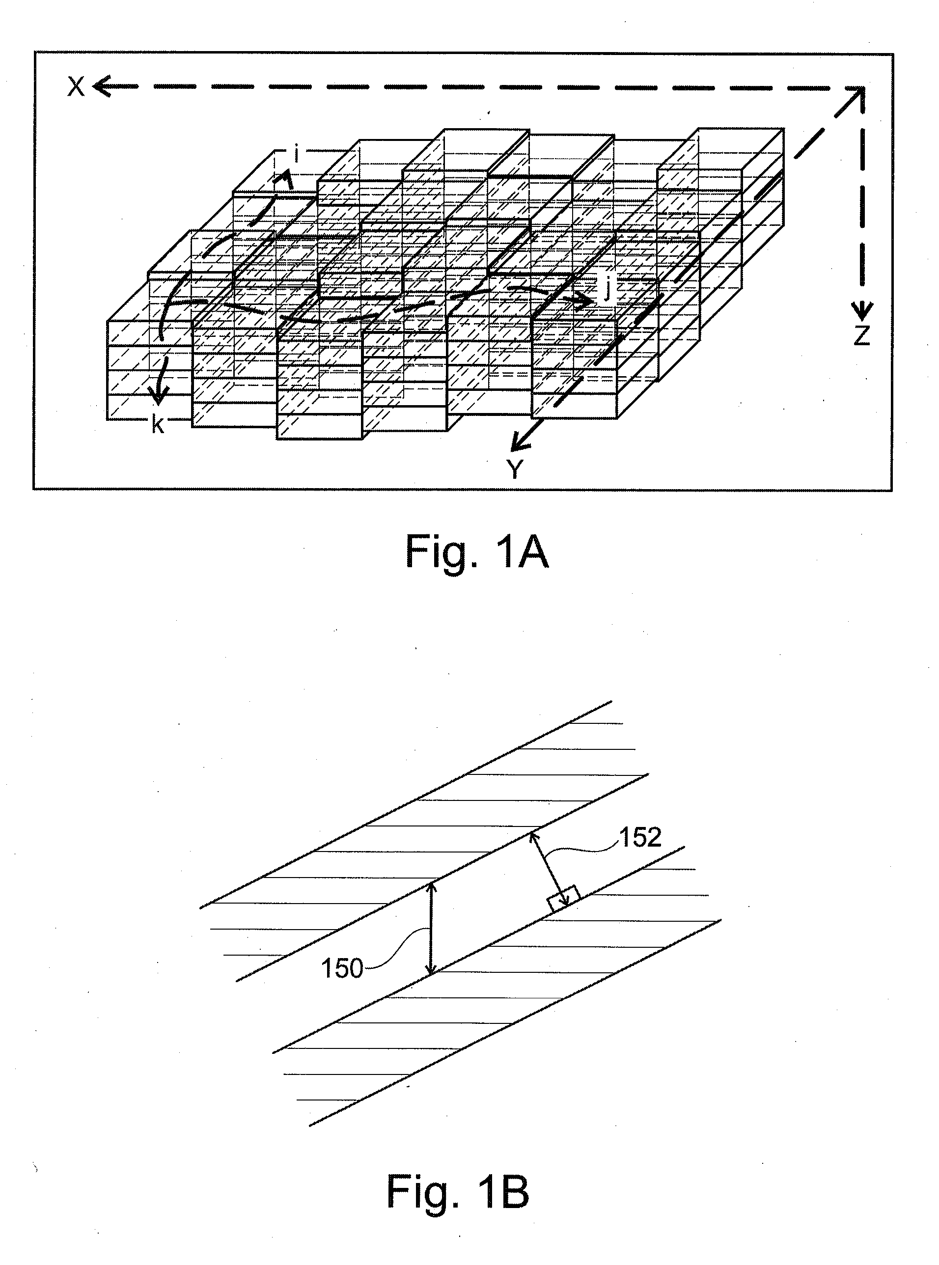
[0051]FIG. 1A schematically illustrates a three dimensional model of a volume of the Earth for use in modelling of, for example, an oil reservoir. In FIG. 1A, the modelled portion of the Earth's volume can be represented in terms of the Cartesian coordinates represented an x-axis 102, a y-axis 104 and a z-axis 106. The Cartesian coordinates, which give a position (x, y, z) in the grid represent the true spatial location at the time that one or more geological parameters are measured.

[0052]The Earth volume 100 can alternatively be referenced via a set of grid indices along an i-trajectory 110, a j-trajectory 112 and a k-trajectory 114, which give alternative coordinates (i, j, k) for a given point in space. As shown in FIG. 1, the i, j, and k trajectories do not necessarily follow any straight vector in Cartesian space, but instead a references relative to a matrix position within the geological model, itself. Likewise, other alternative vectors can be defined, such as in FIG. 1B, wh...


PUM


Abstract

A method of processing geological data is provided for input to a geostatistical modelling algorithm to predict a value for a parameter relating to a physical property of the Earth. An input data set corresponding to a measured geological parameter is processed to determine a characteristic function of the input data with respect to a geological measure. The input data is transformed to reduce spatial bias with respect to the geological distance measure by applying an inverse function. A statistical weighting is calculated for the transformation and the transformation and weighting are used to predict a representative value of the physical property corresponding to the measured geological parameter. A data processing apparatus and computer program product are also provided.

Description

CROSS-REFERENCE TO RELATED APPLICATIONS[0001]This patent application claims foreign priority to pending UK Patent Application No. GB1420911.8 filed Nov. 25, 2014, entitled “Apparatus and Method for Making Geological Predictions by Processing Geological Parameter Measurements”.INCORPORATION BY REFERENCE[0002]This patent application incorporates by reference in its entirety copending UK Patent Application No. GB1420911.8 filed Nov. 25, 2014, entitled “Apparatus and Method for Making Geological Predictions by Processing Geological Parameter Measurements”.FIELD OF THE INVENTION[0003]The present invention relates to an apparatus and method for determining a predicted value for a parameter relating a physical property of the Earth's interior from processed geological data.BACKGROUND OF THE INVENTION[0004]Various methods of computing three dimensional realisations of subsoil properties from sparsely sampled geological data, to be used for example in characterising hydrocarbon resources, ar...

Claims


Application Information

Patent Timeline
IPC IPC(8): G01V99/00
CPCG01V99/005G01V1/306G01V2210/665G01V20/00G01V1/30G01V3/38G01V11/00
Inventor JOHNSON, LUKE
Owner COGNITIVE GEOLOGY
Why Eureka
Try Eureka