Location determination in multi-system gnns environment using conversion of data into a unified format

a multi-system gns and data technology, applied in satellite radio beaconing, measurement devices, instruments, etc., can solve the problems of reducing affecting the accuracy of the first position, so as to improve the tracking sensitivity, improve the time to first fix, and improve the effect of the first fix

Inactive Publication Date: 2015-03-12
ERIDE +1
View PDF10 Cites 4 Cited by
  • Summary
  • Abstract
  • Description
  • Claims
  • Application Information

AI Technical Summary

Benefits of technology

[0016]Converting a Glonass satellite ephemeris navigation model into a Unified GPS ephemeris format in many instances improves time to first fix of GNSS receiver and improves tracking sensitivity in weak signal environments as a single observation of the broadcast ephemeris can be used much longer than the time available with the native model. Efficiency is achieved by representing all satellite models in a unified format, preferably the GPS ephemeris format.
[0017]Embodiments of the present invention include an electronic device including a GNSS receiver able to collect Glonass ephemeris information from orbiting Glonass satellites and to use that information to build up modified Glonass ephemeris model in the unified format that will be valid and useful for several orders of magnitude longer than the original validity time period of Glonass ephemeris model. Advantages include reducing time to first fix, extending the validity time of Glonass ephemeris, and simplifying the GNSS receiver's software design by enabling it to do all navigation model computation in GPS ephemeris format.

Problems solved by technology

A lack of time and / or a lack of strong signal can frustrate a user trying to get a quick first position fix.
However, this error grows significantly over time, if the model is used beyond the validity time interval.

Method used


Image

  • Location determination in multi-system gnns environment using conversion of data into a unified format
  • Location determination in multi-system gnns environment using conversion of data into a unified format
  • Location determination in multi-system gnns environment using conversion of data into a unified format

Examples


Embodiment Construction

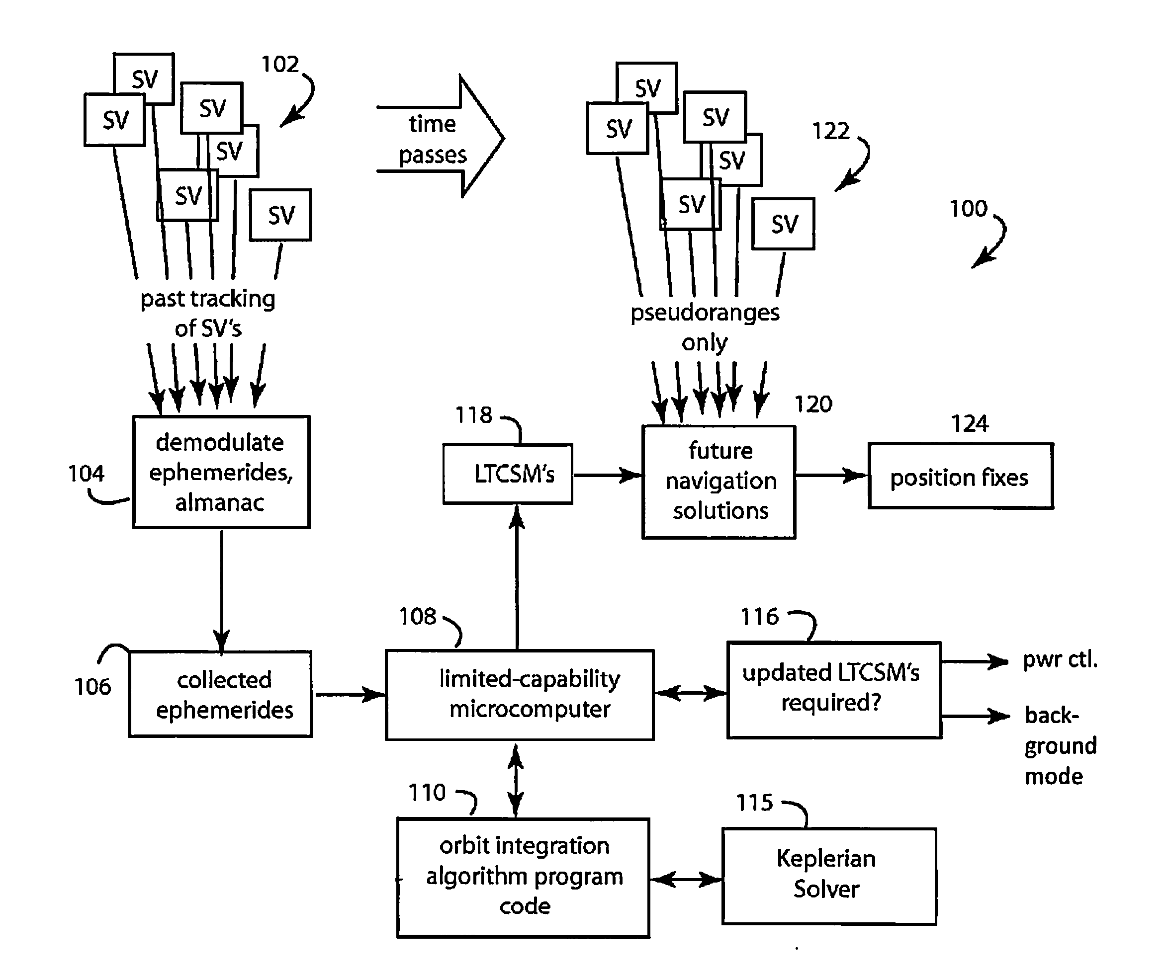
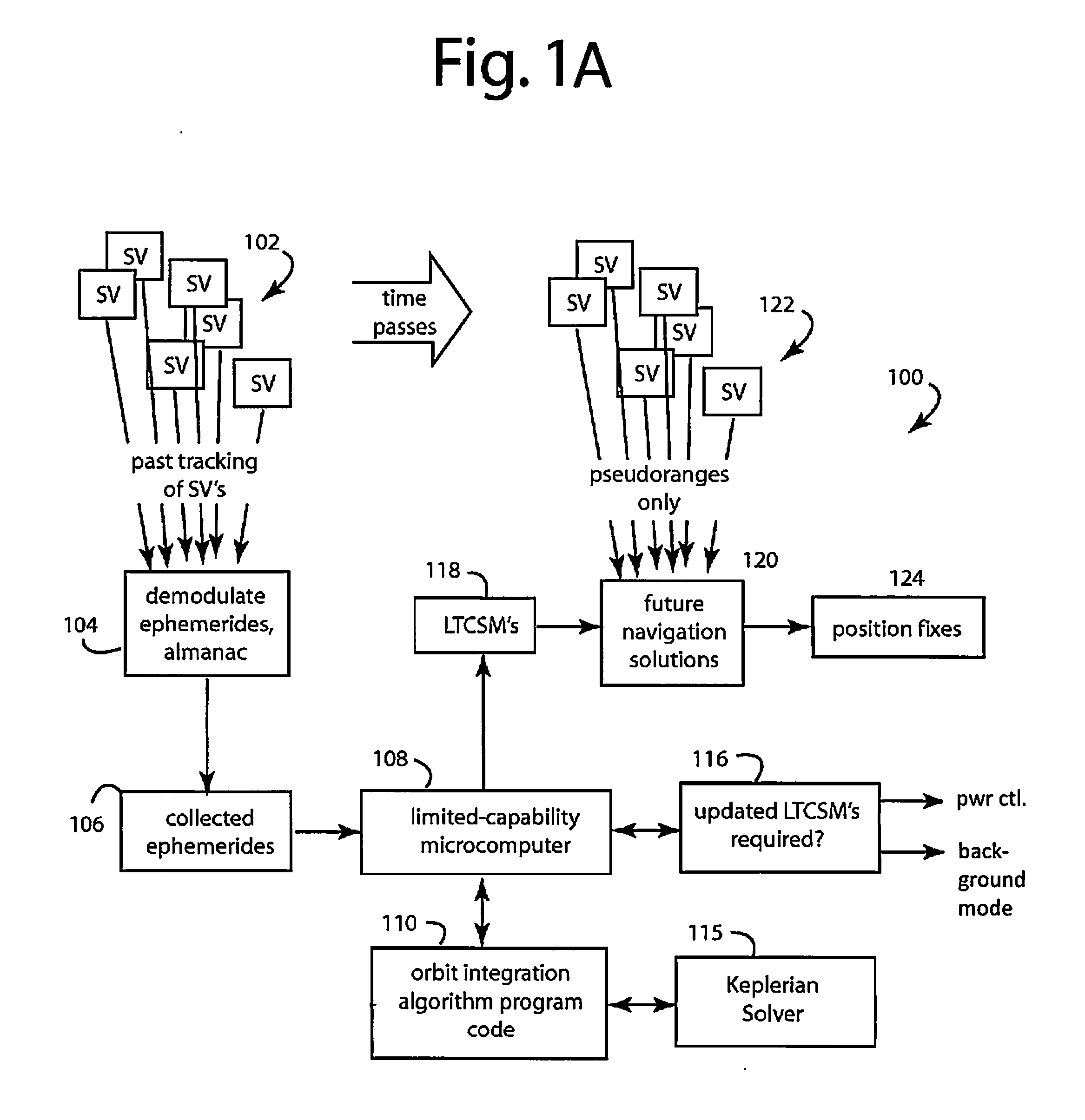
[0029]Referring now to FIG. 1A, a diagram is shown of an electronic device, such as a mobile electronic device, a server-based system, etc., having extended ephemeris satellite navigation capabilities, referred to herein by the general reference numeral 100. Over time, continually varying constellations of all the orbiting satellite vehicles (SV's) 102 transmit microwave signals that include their then-up-to-date respective ephemerides. A processor 104 demodulates these ephemerides (and / or the almanacs that include them) opportunistically over time (over days or even weeks). The processor 104 may be part of a mobile electronic device, or may be in communication with a server-based system. A complete collection 106 of the ephemerides and the almanacs may then be made available on an on-going basis to a microcomputer 108.

[0030]The satellite vehicles 102 may belong to different satellite navigations systems, e.g., GPS, Glonass, etc. Navigation Messages transmitted by the SVs 102 will b...


PUM


Abstract

Accurate long term satellite models for satellites include satellites of different navigation systems. Such a model is derived for a non-GPS satellite that broadcasts native orbital model data specified as valid within a first time period. Initial position and velocity data are determined from the native orbital model data, and orbit integration is performed to determine an orbital arc in an earth-centered-earth-fixed frame over a second time period longer than the first time period. Initial estimates of GPS or GPS-like orbit parameters are determined for the non-GPS satellite, and the orbital arc and the initial estimates of the GPS or GPS-like orbit parameters are input to an orbit parameter solver that determines GPS or GPS-like parameters that fit the orbital arc and is used to determine final orbital model parameters in GPS or GPS-like format for the non-GPS satellite.

Description

BACKGROUND OF THE INVENTION[0001]1. Field of the Invention[0002]The present invention relates to satellite navigation receivers.[0003]2. Description of the Prior Art[0004]Mobile phones, tablets, digital cameras, and many other electronic devices now come routinely equipped with GNSS (Global Navigation Satellite System) receivers that provide position fixes for their users. GNSS refers generically to satellite based navigation systems. GNSS may comprise several systems that are currently operational or in development. The United States' Global Positioning System (GPS) is the oldest system and currently the main system. Most of the existing GNSS receivers only support GPS system and are simply called GPS receiver. Russia's Glonass system is the only alternative navigational system in operation with global coverage and of comparable precision. Europe is building its own GALILEO system and so are few other countries, including Japan (QZSS), India (Galan), and China (Beidou).[0005]In the...

Claims


Application Information

Patent Timeline
Patent Type & Authority Applications(United States)
IPC IPC(8): G01S19/27G01S19/25
CPCG01S19/258G01S19/27
Inventor REZAEI, SHAHRAMMCBURNEY, PAUL W.
Owner ERIDE
Why Eureka
Try Eureka