
Method and system for mapping road conditions by means of terminals

a technology of road conditions and terminals, applied in traffic control systems, navigation instruments, instruments, etc., can solve problems such as inability to quickly transmit reliable weather data, prior art has considerable drawbacks, etc., to achieve the effect of minimizing data transmission costs, reducing the cost of data transmission, and saving capacity

Inactive Publication Date: 2012-11-08
TECONER
View PDF48 Cites 20 Cited by
  • Summary
  • Abstract
  • Description
  • Claims
  • Application Information

AI Technical Summary

Benefits of technology

[0014]Considerable advantages are achieved with the present invention. Namely, use of the invention allows informing the road users about changed driving conditions with a very short response time before the deterioration of the driving conditions has even has had a chance of having an effect on the flow of traffic. In the best case the response time of information can be reduced from tens of minutes to a level of minutes. Thus, by means of the invention communication about slipperyness, traffic congestion or other similar exceptional conditions can be changed from reactive to proactive. The advantage of the friction determined by means of an acceleration sensor according to the invention is additionally that the measurement is absolute with no need for work-intensive calibrations.
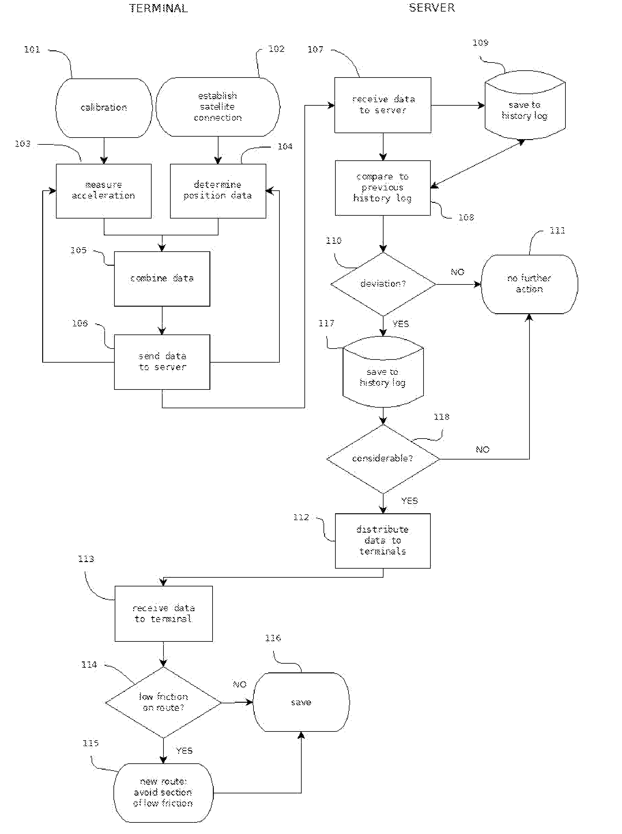
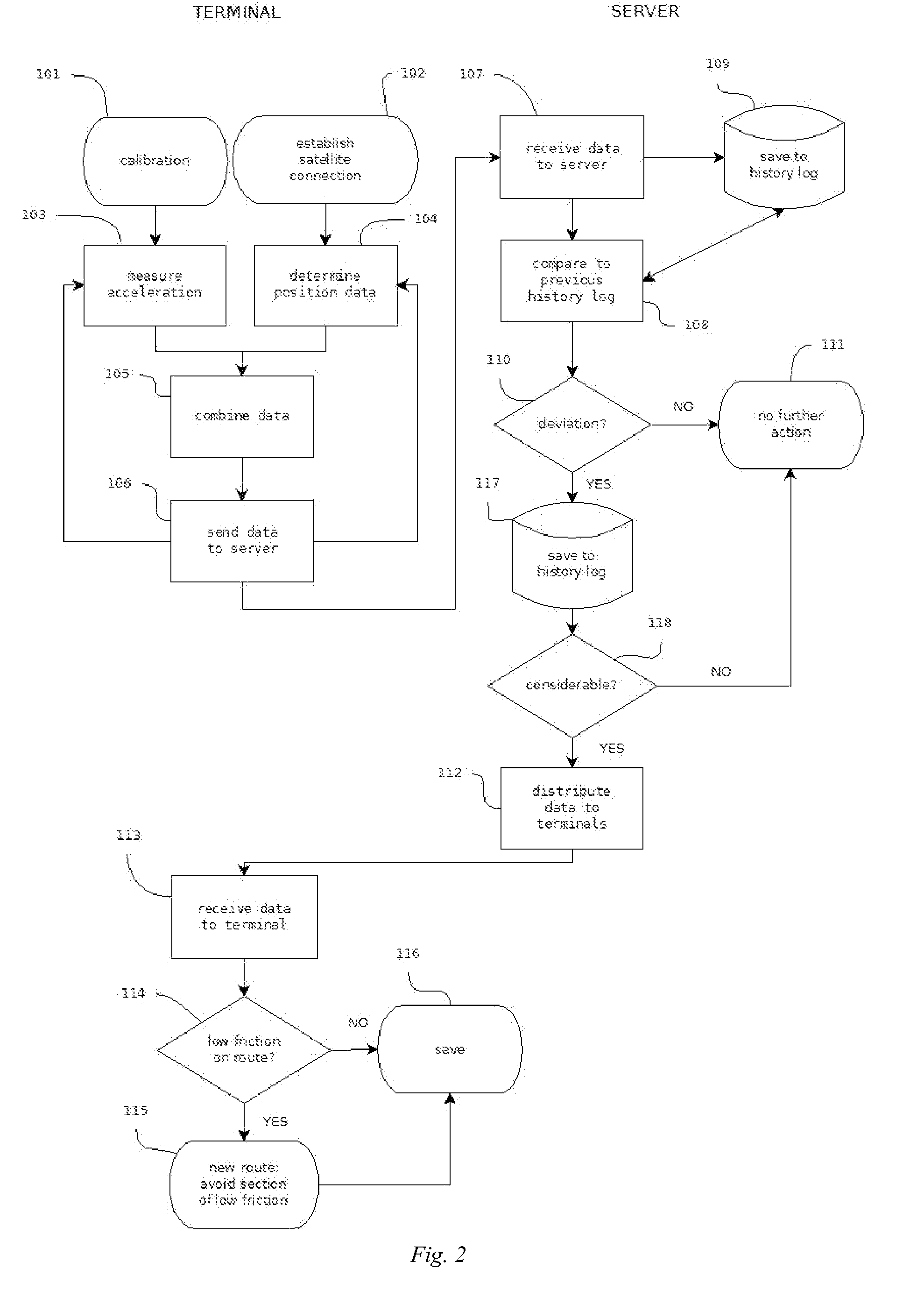
[0016]According to one embodiment the data terminal equipment only sends data to the server if the acceleration value measured by it is different from the value in the database of the data terminal equipment. This embodiment provides the advantage that the data transmitted from the data terminal equipment can be minimized for minimizing the data transfer costs.

Problems solved by technology

Defining the friction on the basis of weather observations has been challenging but the actual friction in existing conditions has been estimated in prior art technology by means of a number of acceleration sensor-based solutions.
Prior art has, however, some considerable drawbacks.
The performance of the navigation systems in practical traffic situations, however, depends on local, sometimes quickly developing traffic limitations, such as especially the slipperyness caused by weather, but also traffic jams, accidents and similar unexpected changes in the transmission capacity of the road.
Especially the currently available slipperyness data are far too general to describe the drivability of a certain portion of road and usually they are based on a road weather forecast or deficient road weather measurements.
Thus current systems can not quickly transmit reliable data about weather, more especially the real friction of the road surface.

Method used


Image

  • Method and system for mapping road conditions by means of terminals
  • Method and system for mapping road conditions by means of terminals
  • Method and system for mapping road conditions by means of terminals

Examples


Embodiment Construction

[0021]In the present embodiment the data collected about the traffic conditions is thus based on centralized data produced and transmitted by road users. On one hand, the data sent by the road users is position data that according to the embodiment can be produced by means of alternative ways, and on the other hand it is data produced by the acceleration sensor of the data terminal equipment that can also have been produced by means of alternative ways. Transmission and analysing of the data can also be carried out in alternative ways according to different embodiments of the invention.

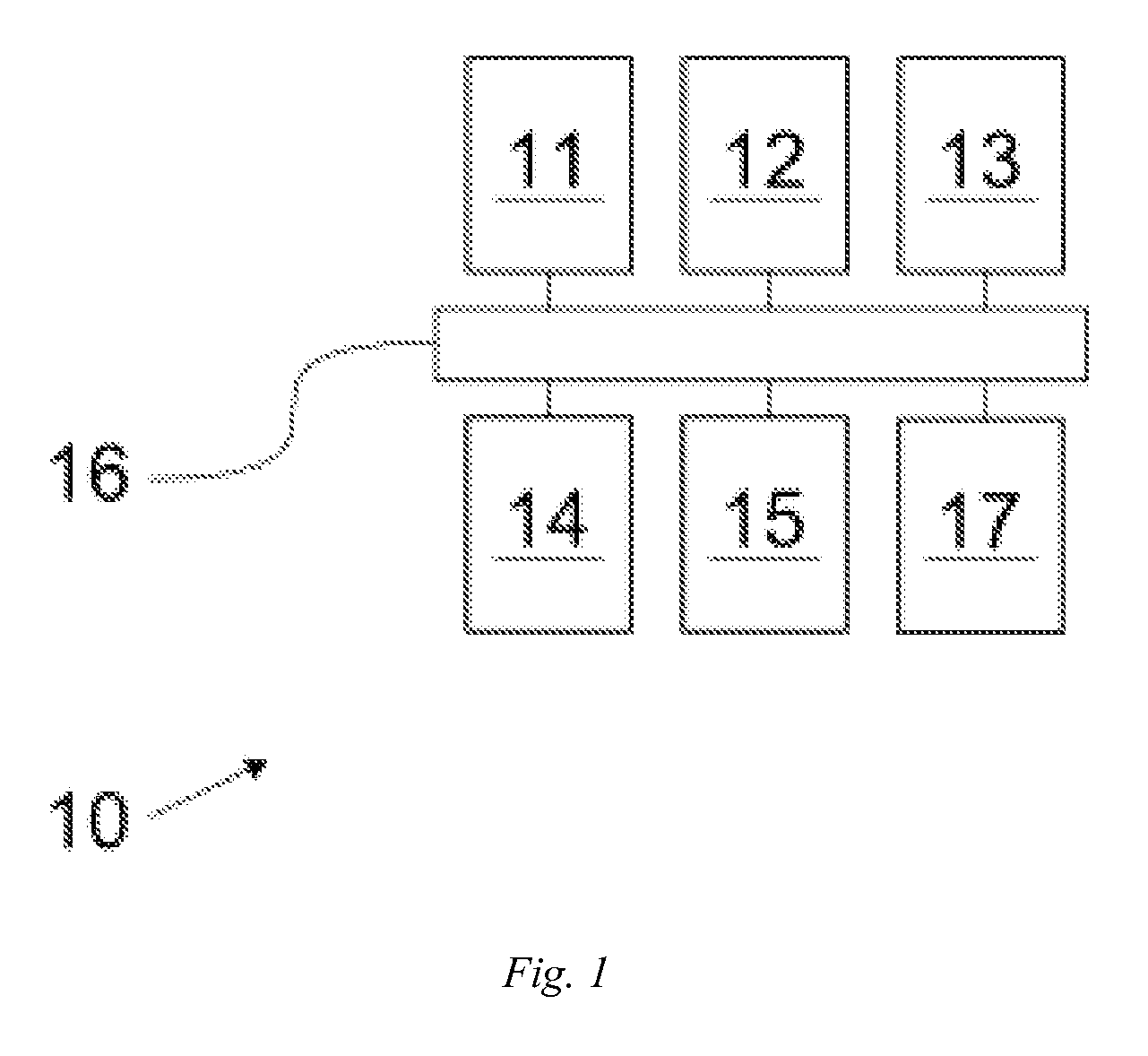
[0022]As has been said in the above, the embodiment makes use of the acceleration sensors and positioning devices of the road users' data terminal equipment. Preferable data terminal equipment units 10 for the embodiment include mobile phones (FIG. 1). Most so-called intelliphones are namely equipped with a software-readable acceleration sensor 11 and positioning means 12, such as a satellite position...


PUM


Abstract

The present invention relates to methods, computer software products, server and system for mapping road conditions, especially friction. In the method according to the invention the acceleration of the vehicle is measured b means of an acceleration sensor, the position of the vehicle is monitored by means of positioning means and the measured acceleration value is combined with the position data of the measurement location. The method compares whether the measured position-specific acceleration value exceeds the value on the server for the said area and in case the value is exceeded, a measured position-specific acceleration value is sent to the server.

Description

FIELD OF THE INVENTION[0001]The present invention relates to measuring traffic data by means of utilizing the sensors of data terminal equipment. The invention relates especially to collecting data concerning surface slipperyness and congestion by means of road users' data terminal equipment, such as mobile phones, acceleration sensors and positioning sensors More specifically the present invention relates to methods, server and computer software products according to preambles of claims 1, 6, 7, 10 and 12.BACKGROUND ART[0002]To ensure efficient flow of traffic it is important that the road network is in efficient condition and that the road users have up-to-date data about the current conditions and any exceptional arrangements. In prior art, data about traffic conditions has been acquired and distributed by means of a number of methods. The effect of weather on traffic conditions has been estimated on the basis weather forecasts as well as data from road weather cameras and weathe...

Claims


Application Information

Patent Timeline
IPC IPC(8): G01C21/32G01C21/34
CPCG01C21/32G01C21/34G01C21/3691G08G1/096791G01C21/3844G01C21/3822G01C21/3837G01P21/00B60W40/06
Inventor HAAVASOJA, TAISTO
Owner TECONER
Learn More