
Raster-based contour swathing for guidance and variable-rate chemical application

a technology of variable-rate chemical application and contour swathing, which is applied in the direction of steering initiation, navigation instruments, instruments, etc., can solve the problems of crop rows deviating from straight lines, significant computer overhead can be occupied with such tasks, and the field conditions in many areas are not suitable for a-b guidan

Active Publication Date: 2010-07-22
AGJUNCTION
View PDF22 Cites 61 Cited by
  • Summary
  • Abstract
  • Description
  • Claims
  • Application Information

AI Technical Summary

Benefits of technology

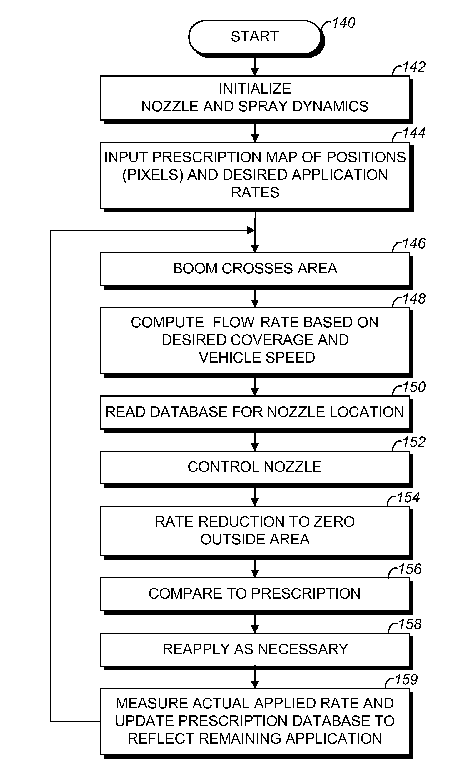
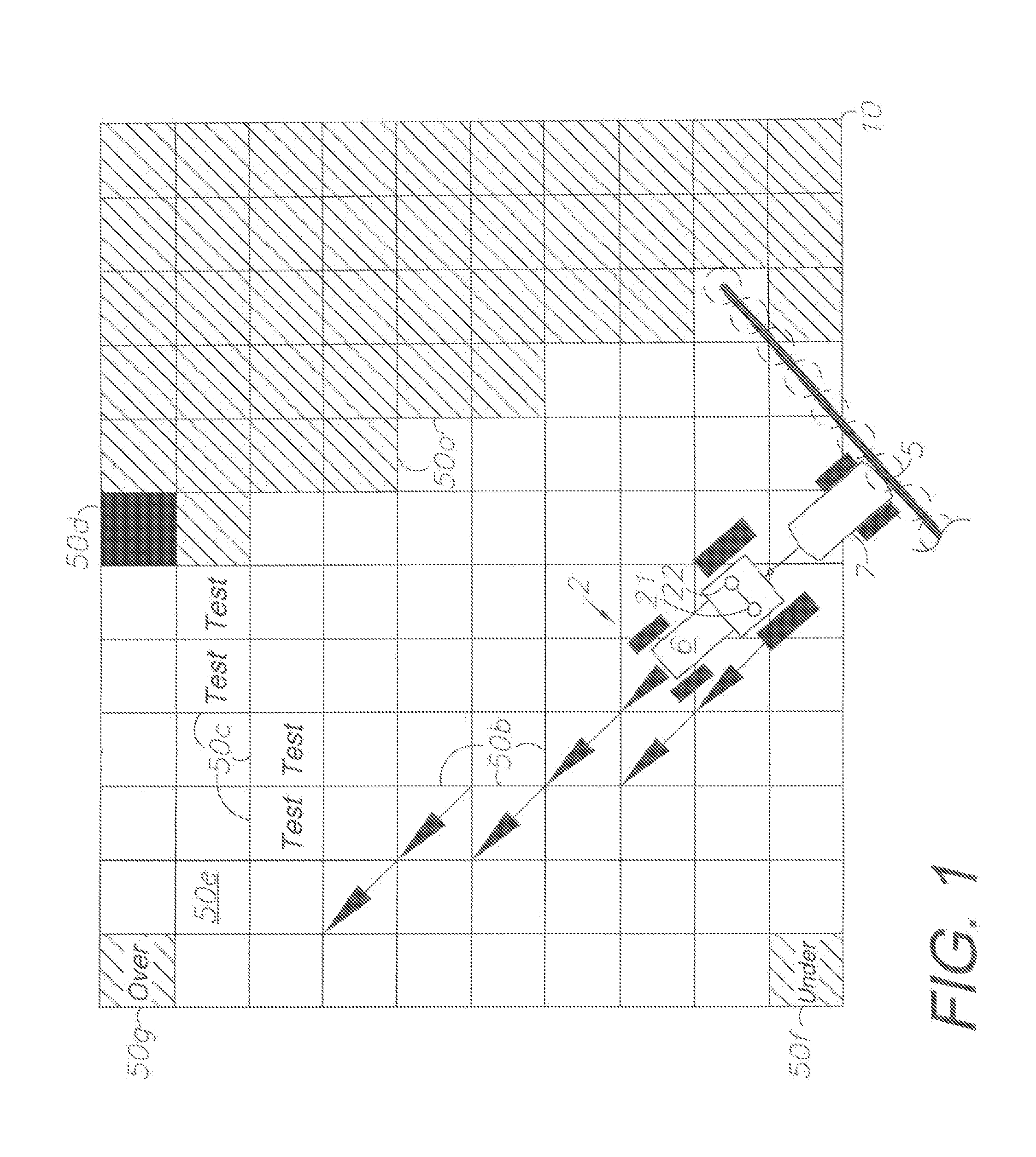
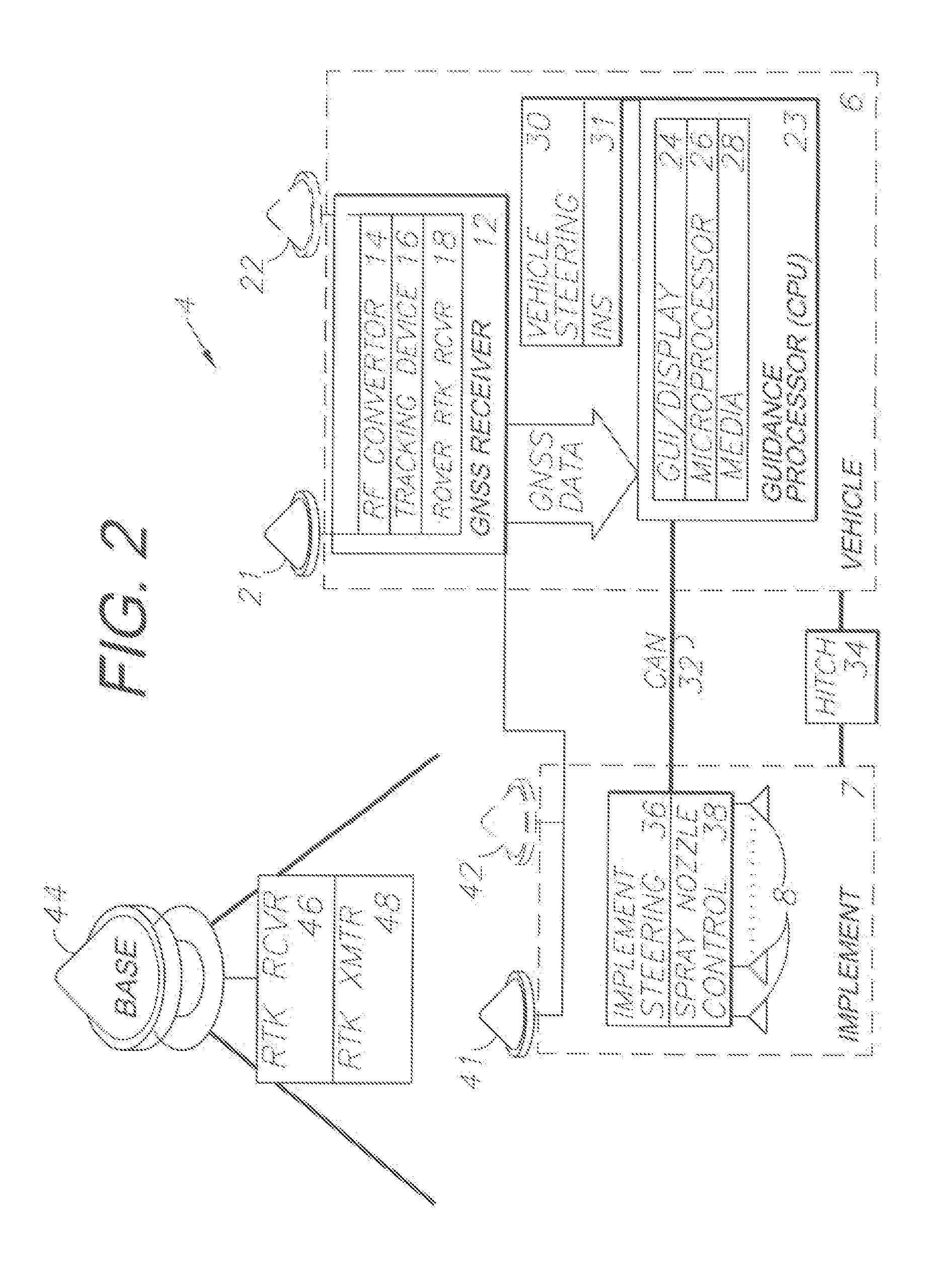
[0013]In the practice of the present invention, a system and method are provided for automatically guiding and controlling vehicles and equipment using GNSS for defining a raster-based database of pixels defining either an entire area to be treated, or a subset through which a vehicle travels. For example, agricultural equipment comprising a tractor and an implement can be equipped with a vector position and heading sensor subsystem including a GNSS receiver and antennas and an optional inertial navigational system (INS) with X, Y and Z axis sensors for sensing equipment attitude changes through six degrees of freedom. Such sensors typically comprise gyroscopes and / or accelerometers. A 2D map array comprises an XY grid of pixels, which is scalable according to the requirements of a particular operation. Guidance operations are accomplished by marking pixels as “applied” when treated on an equipment pass. Subsequent passes can guide off of the applied pixel areas, using “target” aim point pixels and / or swath-width spacing to one side or the other of the applied areas. Moreover, machine control functions can actuate certain operations based on equipment position. For example, spray nozzles on a sprayer implement can be selectively and individually actuated over areas to be sprayed.

Problems solved by technology

A disadvantage with this type of system is that initial form lines must be driven and delineated based upon which subsequent form lines must be computed and followed.
Significant computer overhead can be occupied with such tasks, whereby trade-offs are required between component costs and system responsiveness.
However, field conditions in many areas are not suitable for A-B guidance.
Initial planting passes made with manual and visually-guided navigation, which may or may not be supplemented with GNSS navigational aids, can cause crop rows to deviate from straight lines.

Method used


Image

  • Raster-based contour swathing for guidance and variable-rate chemical application
  • Raster-based contour swathing for guidance and variable-rate chemical application
  • Raster-based contour swathing for guidance and variable-rate chemical application

Examples


Embodiment Construction

I. Introduction and Environment

[0023]As required, detailed embodiments of the present invention are disclosed herein; however, it is to be understood that the disclosed embodiments are merely exemplary of the invention, which may be embodied in various forms. Therefore, specific structural and functional details disclosed herein are not to be interpreted as limiting, but merely as a basis for the claims and as a representative basis for teaching one skilled in the art to variously employ the present invention in virtually any appropriately detailed structure.

[0024]Certain terminology will be used in the following description for convenience in reference only and will not be limiting. For example, up, down, front, back, right and left refer to the invention as oriented in the view being referred to. The words “inwardly” and “outwardly” refer to directions toward and away from, respectively, the geometric center of the embodiment being described and designated parts thereof Global nav...


PUM


Abstract

A raster-based system for GNSS guidance includes a vehicle-mounted GNSS antenna and receiver. A processor provides guidance and / or autosteering commands based on GNSS-defined pixels forming a grid representing an area to be treated, such as a field. Specific guidance and chemical application methods are provided based on the pixel-defined treatment areas and preprogrammed chemical application prescription maps, which can include variable chemical application rates and dynamic control of the individual nozzles of a sprayer.

Description

CROSS-REFERENCE TO RELATED APPLICATIONS[0001]This application claims priority in U.S. Provisional Patent Application No. 61 / 145,542, filed Jan. 17, 2009, which is incorporated herein by reference.BACKGROUND OF THE INVENTION[0002]1. Field of the Invention[0003]The present invention relates generally to automated equipment control using a raster-based database, including vehicle navigation and guidance using global navigation satellite system (GNSS), inertial navigation system (INS) and other positioning inputs, and machine control functions such as variable-rate chemical applications in agricultural spraying.[0004]2. Description of the Related Art[0005]GNSS technology advanced vehicle and machine guidance and control in various technical fields, including the field of agricultural guidance by enabling reliable, accurate systems, which are relatively easy to use. GNSS guidance systems are adapted for displaying directional guidance information to assist operators with manually steerin...

Claims


Application Information

Patent Timeline
Patent Type & Authority Applications(United States)
IPC IPC(8): G01C21/00B62D6/00G06F7/00G06F17/30
CPCA01B69/008A01B79/005G05D2201/0201G05D1/0274G05D1/0278G05D1/027
Inventor MCCLURE, JOHN A.
Owner AGJUNCTION
Learn More